|
|
|||||||||||||||||
| Point ID: 6842 | Downloads | Plots | Site Data | Code: 10437 |
|
|
|||||||||||||||||
| Download | |
|---|---|
| Site Descriptor Information | Site Time Series Data |
| Link to all available data | |
| View: | Time Series | All |
| Units: | m3/s |
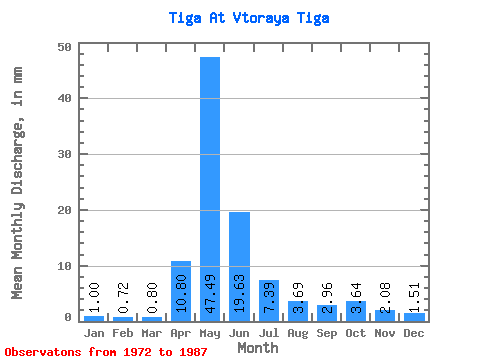
| Statistic | Jan | Feb | Mar | Apr | May | Jun | Jul | Aug | Sep | Oct | Nov | Dec | Annual |
|---|---|---|---|---|---|---|---|---|---|---|---|---|---|
| Mean | 1.00 | 0.72 | 0.80 | 10.80 | 47.48 | 19.63 | 7.39 | 3.69 | 2.96 | 3.64 | 2.08 | 1.51 | 98.37 |
| Standard Deviation | 0.55 | 0.38 | 0.38 | 9.30 | 33.41 | 17.84 | 8.82 | 3.18 | 2.29 | 2.92 | 1.51 | 1.02 | 61.44 |
| Min | 0.51 | 0.42 | 0.45 | 1.29 | 6.78 | 1.40 | 0.70 | 0.53 | 0.62 | 0.87 | 0.53 | 0.55 | 27.86 |
| Max | 2.32 | 1.85 | 1.85 | 28.16 | 115.35 | 75.74 | 32.17 | 12.69 | 8.19 | 9.80 | 4.83 | 3.59 | 264.88 |
| Coefficient of Variation | 0.55 | 0.53 | 0.47 | 0.86 | 0.70 | 0.91 | 1.19 | 0.86 | 0.77 | 0.80 | 0.73 | 0.68 | 0.62 |
 Return to R-Arctic Net Home Page