|
|
|||||||||||||||||
| Point ID: 6842 | Downloads | Plots | Site Data | Code: 10437 |
|
|
|||||||||||||||||
| Download | |
|---|---|
| Site Descriptor Information | Site Time Series Data |
| Link to all available data | |
| View: | Time Series | All |
| Units: | mm |
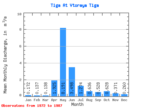
| Statistic | Jan | Feb | Mar | Apr | May | Jun | Jul | Aug | Sep | Oct | Nov | Dec | Annual |
|---|---|---|---|---|---|---|---|---|---|---|---|---|---|
| Mean | 0.17 | 0.14 | 0.14 | 1.93 | 8.19 | 3.50 | 1.27 | 0.64 | 0.53 | 0.63 | 0.37 | 0.26 | 1.44 |
| Standard Deviation | 0.10 | 0.07 | 0.07 | 1.66 | 5.76 | 3.18 | 1.52 | 0.55 | 0.41 | 0.50 | 0.27 | 0.18 | 0.90 |
| Min | 0.09 | 0.08 | 0.08 | 0.23 | 1.17 | 0.25 | 0.12 | 0.09 | 0.11 | 0.15 | 0.10 | 0.10 | 0.41 |
| Max | 0.40 | 0.35 | 0.32 | 5.02 | 19.90 | 13.50 | 5.55 | 2.19 | 1.46 | 1.69 | 0.86 | 0.62 | 3.88 |
| Coefficient of Variation | 0.55 | 0.53 | 0.47 | 0.86 | 0.70 | 0.91 | 1.19 | 0.86 | 0.77 | 0.80 | 0.73 | 0.68 | 0.62 |
 Return to R-Arctic Net Home Page