|
|
|||||||||||||||||
| Point ID: 6826 | Downloads | Plots | Site Data | Code: 10407 |
|
|
|||||||||||||||||
| Download | |
|---|---|
| Site Descriptor Information | Site Time Series Data |
| Link to all available data | |
| View: | Time Series | All |
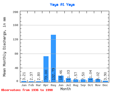
| Units: | m3/s |
| Statistic | Jan | Feb | Mar | Apr | May | Jun | Jul | Aug | Sep | Oct | Nov | Dec | Annual |
|---|---|---|---|---|---|---|---|---|---|---|---|---|---|
| Mean | 3.21 | 2.39 | 2.80 | 73.00 | 132.77 | 18.46 | 11.03 | 7.56 | 7.50 | 11.04 | 8.02 | 3.90 | 280.35 |
| Standard Deviation | 1.25 | 1.03 | 1.46 | 49.56 | 83.18 | 12.71 | 8.16 | 4.10 | 4.69 | 7.92 | 5.22 | 1.70 | 81.04 |
| Min | 0.66 | 0.58 | 0.43 | 3.39 | 10.14 | 1.19 | 0.23 | 0.12 | 0.08 | 0.14 | 0.19 | 0.18 | 23.25 |
| Max | 5.86 | 4.73 | 7.11 | 170.80 | 357.58 | 54.24 | 37.62 | 18.34 | 22.55 | 43.96 | 25.02 | 8.05 | 450.16 |
| Coefficient of Variation | 0.39 | 0.43 | 0.52 | 0.68 | 0.63 | 0.69 | 0.74 | 0.54 | 0.62 | 0.72 | 0.65 | 0.43 | 0.29 |
 Return to R-Arctic Net Home Page