|
|
|||||||||||||||||
| Point ID: 6826 | Downloads | Plots | Site Data | Code: 10407 |
|
|
|||||||||||||||||
| Download | |
|---|---|
| Site Descriptor Information | Site Time Series Data |
| Link to all available data | |
| View: | Time Series | All |
| Units: | mm |
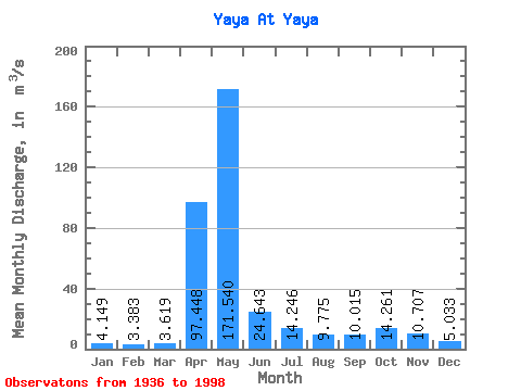
| Statistic | Jan | Feb | Mar | Apr | May | Jun | Jul | Aug | Sep | Oct | Nov | Dec | Annual |
|---|---|---|---|---|---|---|---|---|---|---|---|---|---|
| Mean | 4.15 | 3.38 | 3.62 | 97.45 | 171.54 | 24.64 | 14.25 | 9.78 | 10.02 | 14.26 | 10.71 | 5.03 | 30.73 |
| Standard Deviation | 1.61 | 1.45 | 1.88 | 66.16 | 107.47 | 16.97 | 10.55 | 5.30 | 6.26 | 10.24 | 6.97 | 2.19 | 8.88 |
| Min | 0.85 | 0.82 | 0.55 | 4.52 | 13.10 | 1.59 | 0.30 | 0.16 | 0.11 | 0.18 | 0.25 | 0.23 | 2.55 |
| Max | 7.57 | 6.71 | 9.19 | 228.00 | 462.00 | 72.40 | 48.60 | 23.70 | 30.10 | 56.80 | 33.40 | 10.40 | 49.35 |
| Coefficient of Variation | 0.39 | 0.43 | 0.52 | 0.68 | 0.63 | 0.69 | 0.74 | 0.54 | 0.62 | 0.72 | 0.65 | 0.43 | 0.29 |
 Return to R-Arctic Net Home Page