|
|
|||||||||||||||||
| Point ID: 6815 | Downloads | Plots | Site Data | Code: 10385 |
|
|
|||||||||||||||||
| Download | |
|---|---|
| Site Descriptor Information | Site Time Series Data |
| Link to all available data | |
|
|
| View: | Statistics | Time Series |
| Units: | mm |
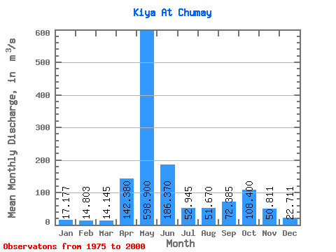
| Statistic | Jan | Feb | Mar | Apr | May | Jun | Jul | Aug | Sep | Oct | Nov | Dec | Annual |
|---|---|---|---|---|---|---|---|---|---|---|---|---|---|
| Mean | 17.18 | 14.80 | 14.14 | 142.38 | 598.90 | 186.37 | 52.95 | 51.67 | 72.39 | 108.40 | 50.81 | 22.71 | 111.89 |
| Standard Deviation | 5.21 | 4.72 | 5.89 | 79.33 | 118.94 | 112.05 | 17.62 | 25.91 | 41.96 | 44.73 | 24.18 | 6.64 | 18.73 |
| Min | 9.14 | 6.67 | 6.39 | 39.80 | 386.00 | 55.00 | 29.80 | 21.20 | 20.70 | 29.30 | 16.90 | 9.40 | 84.64 |
| Max | 27.70 | 24.70 | 29.70 | 303.00 | 827.00 | 531.00 | 95.10 | 135.00 | 154.00 | 176.00 | 130.00 | 34.90 | 150.97 |
| Coefficient of Variation | 0.30 | 0.32 | 0.42 | 0.56 | 0.20 | 0.60 | 0.33 | 0.50 | 0.58 | 0.41 | 0.48 | 0.29 | 0.17 |
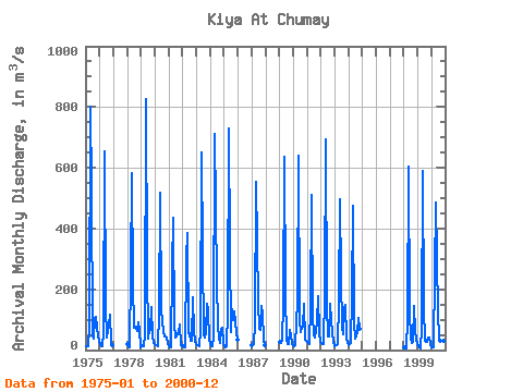
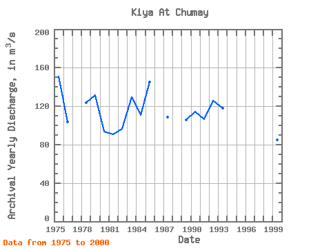
| Year | Jan | Feb | Mar | Apr | May | Jun | Jul | Aug | Sep | Oct | Nov | Dec | Annual | 1975 | 11.80 | 13.60 | 12.50 | 68.70 | 802.00 | 531.00 | 43.50 | 36.50 | 106.00 | 109.00 | 45.50 | 31.60 | 150.97 | 1976 | 20.00 | 13.40 | 11.50 | 57.70 | 653.00 | 143.00 | 42.00 | 61.70 | 84.00 | 117.00 | 26.40 | 17.20 | 103.91 | 1978 | 21.30 | 12.70 | 10.10 | 258.00 | 584.00 | 221.00 | 74.90 | 77.10 | 61.60 | 91.20 | 64.80 | 9.40 | 123.84 | 1979 | 11.30 | 16.30 | 12.40 | 53.40 | 827.00 | 271.00 | 38.80 | 68.00 | 67.40 | 143.00 | 43.30 | 23.80 | 131.31 | 1980 | 20.70 | 16.10 | 12.60 | 120.00 | 518.00 | 130.00 | 95.10 | 58.30 | 43.80 | 46.30 | 41.00 | 21.40 | 93.61 | 1981 | 16.50 | 10.50 | 9.86 | 274.00 | 434.00 | 84.40 | 40.30 | 51.70 | 57.60 | 83.40 | 16.90 | 13.00 | 91.01 | 1982 | 16.20 | 10.30 | 9.03 | 303.00 | 386.00 | 55.00 | 54.50 | 30.90 | 30.80 | 175.00 | 63.20 | 26.30 | 96.69 | 1983 | 16.40 | 14.90 | 12.80 | 66.30 | 650.00 | 322.00 | 52.60 | 39.50 | 59.20 | 154.00 | 130.00 | 31.30 | 129.08 | 1984 | 22.40 | 14.00 | 11.20 | 39.80 | 710.00 | 224.00 | 82.40 | 36.80 | 22.70 | 71.60 | 73.20 | 23.60 | 110.97 | 1985 | 14.30 | 10.60 | 10.80 | 128.00 | 731.00 | 330.00 | 57.60 | 135.00 | 100.00 | 128.00 | 59.50 | 34.90 | 144.97 | 1987 | 15.60 | 21.10 | 21.00 | 84.70 | 554.00 | 159.00 | 69.40 | 65.60 | 144.00 | 120.00 | 35.30 | 14.80 | 108.71 | 1989 | 27.70 | 24.70 | 29.70 | 151.00 | 635.00 | 188.00 | 34.00 | 21.20 | 20.70 | 68.00 | 48.80 | 21.30 | 105.84 | 1990 | 16.20 | 14.30 | 16.10 | 164.00 | 639.00 | 96.80 | 58.00 | 74.10 | 76.10 | 152.00 | 32.40 | 30.10 | 114.09 | 1991 | 26.80 | 21.60 | 19.20 | 144.00 | 509.00 | 113.00 | 50.50 | 42.40 | 93.10 | 176.00 | 58.60 | 27.00 | 106.77 | 1992 | 22.60 | 21.40 | 20.30 | 183.00 | 694.00 | 148.00 | 46.30 | 45.40 | 154.00 | 97.40 | 55.40 | 25.30 | 126.09 | 1993 | 13.20 | 15.60 | 18.30 | 159.00 | 498.00 | 239.00 | 71.80 | 50.20 | 135.00 | 150.00 | 39.90 | 21.70 | 117.64 | 1994 | 17.50 | 18.30 | 21.90 | 173.00 | 475.00 | 91.20 | 39.30 | 58.90 | 107.00 | 68.50 | 1998 | 9.14 | 6.67 | 6.83 | 97.20 | 605.00 | 122.00 | 37.00 | 22.40 | 27.20 | 146.00 | 60.40 | 19.80 | 96.64 | 1999 | 13.70 | 10.60 | 6.39 | 71.80 | 590.00 | 139.00 | 29.80 | 25.50 | 26.90 | 42.30 | 40.50 | 19.20 | 84.64 | 2000 | 10.20 | 9.38 | 10.40 | 251.00 | 484.00 | 120.00 | 41.10 | 32.20 | 30.60 | 29.30 | 30.30 | 19.80 | 89.02 |
|---|
 Return to R-Arctic Net Home Page