|
|
|||||||||||||||||
| Point ID: 6778 | Downloads | Plots | Site Data | Code: 10292 |
|
|
|||||||||||||||||
| Download | |
|---|---|
| Site Descriptor Information | Site Time Series Data |
| Link to all available data | |
| View: | Time Series | All |
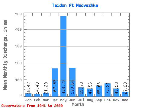
| Units: | m3/s |
| Statistic | Jan | Feb | Mar | Apr | May | Jun | Jul | Aug | Sep | Oct | Nov | Dec | Annual |
|---|---|---|---|---|---|---|---|---|---|---|---|---|---|
| Mean | 18.46 | 14.52 | 21.29 | 167.92 | 478.66 | 170.60 | 53.77 | 47.55 | 65.66 | 77.30 | 47.23 | 27.29 | 1181.85 |
| Standard Deviation | 15.70 | 14.38 | 22.07 | 88.74 | 104.48 | 117.44 | 28.73 | 25.56 | 37.63 | 31.22 | 26.13 | 15.85 | 213.96 |
| Min | 3.28 | 2.77 | 5.54 | 37.81 | 231.56 | 17.95 | 18.16 | 15.42 | 15.75 | 22.75 | 15.71 | 9.77 | 798.35 |
| Max | 100.68 | 86.41 | 117.39 | 411.21 | 704.74 | 493.06 | 125.64 | 151.01 | 155.32 | 148.80 | 133.89 | 95.44 | 1851.48 |
| Coefficient of Variation | 0.85 | 0.99 | 1.04 | 0.53 | 0.22 | 0.69 | 0.53 | 0.54 | 0.57 | 0.40 | 0.55 | 0.58 | 0.18 |
 Return to R-Arctic Net Home Page