|
|
|||||||||||||||||
| Point ID: 6778 | Downloads | Plots | Site Data | Code: 10292 |
|
|
|||||||||||||||||
| Download | |
|---|---|
| Site Descriptor Information | Site Time Series Data |
| Link to all available data | |
| View: | Time Series | All |
| Units: | mm |
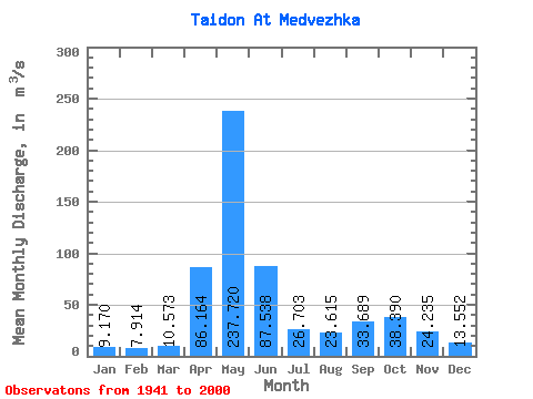
| Statistic | Jan | Feb | Mar | Apr | May | Jun | Jul | Aug | Sep | Oct | Nov | Dec | Annual |
|---|---|---|---|---|---|---|---|---|---|---|---|---|---|
| Mean | 9.17 | 7.91 | 10.57 | 86.16 | 237.72 | 87.54 | 26.70 | 23.61 | 33.69 | 38.39 | 24.23 | 13.55 | 49.80 |
| Standard Deviation | 7.80 | 7.84 | 10.96 | 45.53 | 51.89 | 60.26 | 14.27 | 12.69 | 19.31 | 15.51 | 13.41 | 7.87 | 9.02 |
| Min | 1.63 | 1.51 | 2.75 | 19.40 | 115.00 | 9.21 | 9.02 | 7.66 | 8.08 | 11.30 | 8.06 | 4.85 | 33.64 |
| Max | 50.00 | 47.10 | 58.30 | 211.00 | 350.00 | 253.00 | 62.40 | 75.00 | 79.70 | 73.90 | 68.70 | 47.40 | 78.03 |
| Coefficient of Variation | 0.85 | 0.99 | 1.04 | 0.53 | 0.22 | 0.69 | 0.53 | 0.54 | 0.57 | 0.40 | 0.55 | 0.58 | 0.18 |
 Return to R-Arctic Net Home Page