|
|
|||||||||||||||||
| Point ID: 6732 | Downloads | Plots | Site Data | Code: 10181 |
|
|
|||||||||||||||||
| Download | |
|---|---|
| Site Descriptor Information | Site Time Series Data |
| Link to all available data | |
| View: | Time Series | All |
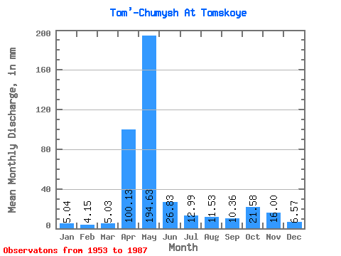
| Units: | m3/s |
| Statistic | Jan | Feb | Mar | Apr | May | Jun | Jul | Aug | Sep | Oct | Nov | Dec | Annual |
|---|---|---|---|---|---|---|---|---|---|---|---|---|---|
| Mean | 5.04 | 4.18 | 5.03 | 100.13 | 194.60 | 26.82 | 12.99 | 11.53 | 10.36 | 21.58 | 15.99 | 6.57 | 414.04 |
| Standard Deviation | 1.52 | 1.25 | 1.66 | 59.90 | 108.74 | 20.62 | 6.04 | 7.26 | 5.33 | 17.60 | 16.90 | 2.98 | 97.42 |
| Min | 2.54 | 2.15 | 2.36 | 6.60 | 34.65 | 6.84 | 4.71 | 4.15 | 3.78 | 5.83 | 4.02 | 3.22 | 237.49 |
| Max | 7.75 | 6.95 | 8.37 | 229.80 | 451.29 | 91.80 | 30.00 | 42.09 | 25.74 | 75.63 | 94.80 | 16.80 | 613.18 |
| Coefficient of Variation | 0.30 | 0.30 | 0.33 | 0.60 | 0.56 | 0.77 | 0.47 | 0.63 | 0.51 | 0.82 | 1.06 | 0.45 | 0.23 |
 Return to R-Arctic Net Home Page