|
|
|||||||||||||||||
| Point ID: 6732 | Downloads | Plots | Site Data | Code: 10181 |
|
|
|||||||||||||||||
| Download | |
|---|---|
| Site Descriptor Information | Site Time Series Data |
| Link to all available data | |
| View: | Time Series | All |
| Units: | mm |
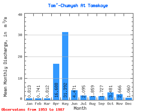
| Statistic | Jan | Feb | Mar | Apr | May | Jun | Jul | Aug | Sep | Oct | Nov | Dec | Annual |
|---|---|---|---|---|---|---|---|---|---|---|---|---|---|
| Mean | 0.81 | 0.74 | 0.81 | 16.69 | 31.39 | 4.47 | 2.10 | 1.86 | 1.73 | 3.48 | 2.67 | 1.06 | 5.67 |
| Standard Deviation | 0.25 | 0.22 | 0.27 | 9.98 | 17.54 | 3.44 | 0.97 | 1.17 | 0.89 | 2.84 | 2.82 | 0.48 | 1.33 |
| Min | 0.41 | 0.38 | 0.38 | 1.10 | 5.59 | 1.14 | 0.76 | 0.67 | 0.63 | 0.94 | 0.67 | 0.52 | 3.25 |
| Max | 1.25 | 1.23 | 1.35 | 38.30 | 72.80 | 15.30 | 4.84 | 6.79 | 4.29 | 12.20 | 15.80 | 2.71 | 8.39 |
| Coefficient of Variation | 0.30 | 0.30 | 0.33 | 0.60 | 0.56 | 0.77 | 0.47 | 0.63 | 0.51 | 0.82 | 1.06 | 0.45 | 0.23 |
 Return to R-Arctic Net Home Page