|
|
|||||||||||||||||
| Point ID: 6682 | Downloads | Plots | Site Data | Code: 10066 |
|
|
|||||||||||||||||
| Download | |
|---|---|
| Site Descriptor Information | Site Time Series Data |
| Link to all available data | |
|
|
| View: | Statistics | Time Series |
| Units: | mm |
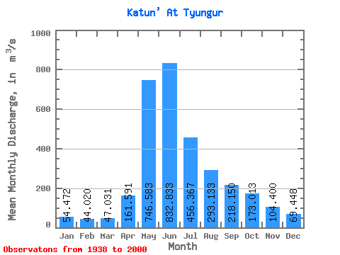
| Statistic | Jan | Feb | Mar | Apr | May | Jun | Jul | Aug | Sep | Oct | Nov | Dec | Annual |
|---|---|---|---|---|---|---|---|---|---|---|---|---|---|
| Mean | 54.47 | 44.02 | 47.03 | 161.59 | 746.58 | 832.83 | 456.37 | 293.13 | 218.15 | 173.01 | 104.40 | 69.45 | 256.40 |
| Standard Deviation | 13.15 | 12.65 | 11.36 | 72.34 | 155.96 | 289.47 | 175.84 | 110.70 | 94.93 | 75.79 | 28.25 | 17.22 | 55.17 |
| Min | 27.40 | 18.90 | 22.00 | 70.80 | 263.00 | 300.00 | 198.00 | 145.00 | 8.98 | 89.80 | 61.80 | 42.50 | 163.93 |
| Max | 86.80 | 66.70 | 67.80 | 467.00 | 1060.00 | 1460.00 | 1020.00 | 620.00 | 606.00 | 523.00 | 179.00 | 111.00 | 397.27 |
| Coefficient of Variation | 0.24 | 0.29 | 0.24 | 0.45 | 0.21 | 0.35 | 0.39 | 0.38 | 0.43 | 0.44 | 0.27 | 0.25 | 0.21 |
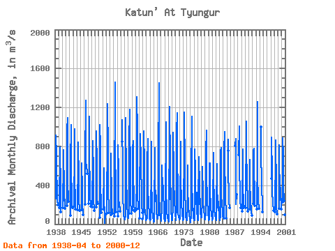
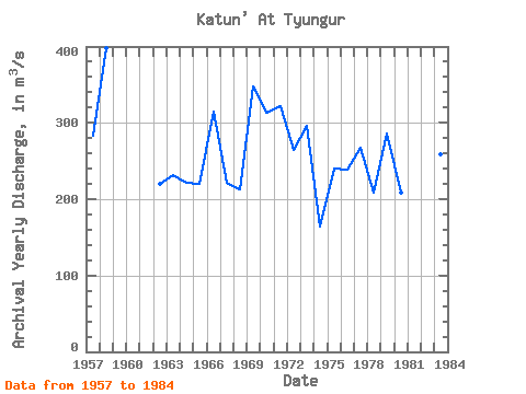
| Year | Jan | Feb | Mar | Apr | May | Jun | Jul | Aug | Sep | Oct | Nov | Dec | Annual | 1938 | 265.00 | 915.00 | 697.00 | 587.00 | 316.00 | 243.00 | 196.00 | 1939 | 167.00 | 790.00 | 579.00 | 570.00 | 212.00 | 125.00 | 1940 | 172.00 | 654.00 | 767.00 | 332.00 | 242.00 | 257.00 | 164.00 | 1941 | 192.00 | 967.00 | 1090.00 | 533.00 | 342.00 | 339.00 | 233.00 | 1942 | 87.40 | 626.00 | 1020.00 | 509.00 | 331.00 | 178.00 | 165.00 | 1943 | 183.00 | 789.00 | 981.00 | 448.00 | 259.00 | 152.00 | 1944 | 145.00 | 662.00 | 842.00 | 454.00 | 214.00 | 191.00 | 141.00 | 1945 | 145.00 | 627.00 | 352.00 | 264.00 | 199.00 | 112.00 | 100.00 | 1946 | 205.00 | 644.00 | 1270.00 | 631.00 | 595.00 | 606.00 | 523.00 | 1947 | 214.00 | 782.00 | 1110.00 | 647.00 | 439.00 | 300.00 | 185.00 | 1948 | 178.00 | 705.00 | 854.00 | 517.00 | 240.00 | 161.00 | 139.00 | 1949 | 173.00 | 753.00 | 955.00 | 596.00 | 256.00 | 212.00 | 1950 | 70.80 | 1020.00 | 793.00 | 342.00 | 268.00 | 197.00 | 119.00 | 1951 | 157.00 | 579.00 | 300.00 | 201.00 | 152.00 | 8.98 | 98.70 | 1952 | 110.00 | 955.00 | 1240.00 | 753.00 | 329.00 | 174.00 | 118.00 | 1953 | 93.20 | 728.00 | 676.00 | 276.00 | 180.00 | 128.00 | 108.00 | 1954 | 85.10 | 263.00 | 1460.00 | 778.00 | 331.00 | 263.00 | 127.00 | 1955 | 78.90 | 815.00 | 534.00 | 219.00 | 179.00 | 227.00 | 131.00 | 1956 | 848.00 | 1070.00 | 518.00 | 240.00 | 250.00 | 170.00 | 99.60 | 55.10 | 1957 | 61.10 | 50.10 | 60.30 | 85.90 | 503.00 | 1090.00 | 465.00 | 489.00 | 207.00 | 174.00 | 126.00 | 86.40 | 283.15 | 1958 | 66.60 | 61.90 | 58.80 | 136.00 | 841.00 | 1180.00 | 1020.00 | 568.00 | 352.00 | 230.00 | 142.00 | 111.00 | 397.27 | 1959 | 145.00 | 772.00 | 854.00 | 456.00 | 327.00 | 201.00 | 134.00 | 1960 | 145.00 | 471.00 | 1310.00 | 959.00 | 620.00 | 311.00 | 164.00 | 1961 | 61.00 | 397.00 | 778.00 | 928.00 | 645.00 | 547.00 | 366.00 | 199.00 | 120.00 | 1962 | 56.20 | 57.00 | 67.80 | 156.00 | 958.00 | 583.00 | 235.00 | 179.00 | 116.00 | 111.00 | 72.00 | 42.50 | 219.46 | 1963 | 46.30 | 65.10 | 61.20 | 74.20 | 614.00 | 881.00 | 334.00 | 237.00 | 165.00 | 142.00 | 105.00 | 54.00 | 231.57 | 1964 | 53.00 | 36.80 | 44.70 | 86.60 | 606.00 | 846.00 | 398.00 | 258.00 | 132.00 | 89.80 | 67.70 | 43.40 | 221.83 | 1965 | 27.40 | 26.00 | 31.20 | 115.00 | 786.00 | 455.00 | 237.00 | 230.00 | 300.00 | 237.00 | 126.00 | 74.90 | 220.46 | 1966 | 58.10 | 54.50 | 50.80 | 116.00 | 643.00 | 1450.00 | 729.00 | 291.00 | 151.00 | 100.00 | 68.40 | 59.10 | 314.24 | 1967 | 50.00 | 34.40 | 30.80 | 174.00 | 606.00 | 351.00 | 410.00 | 391.00 | 293.00 | 186.00 | 87.70 | 52.00 | 222.16 | 1968 | 40.70 | 32.70 | 34.40 | 191.00 | 1050.00 | 395.00 | 347.00 | 145.00 | 106.00 | 93.40 | 64.30 | 60.60 | 213.34 | 1969 | 45.90 | 27.50 | 22.00 | 122.00 | 1010.00 | 1210.00 | 627.00 | 258.00 | 369.00 | 280.00 | 124.00 | 74.30 | 347.48 | 1970 | 40.70 | 36.30 | 48.70 | 184.00 | 801.00 | 943.00 | 539.00 | 376.00 | 308.00 | 256.00 | 121.00 | 98.60 | 312.69 | 1971 | 56.70 | 37.10 | 40.50 | 188.00 | 942.00 | 1140.00 | 667.00 | 357.00 | 174.00 | 119.00 | 68.60 | 68.60 | 321.54 | 1972 | 71.70 | 44.30 | 53.00 | 138.00 | 846.00 | 838.00 | 446.00 | 258.00 | 190.00 | 135.00 | 88.10 | 65.20 | 264.44 | 1973 | 54.40 | 40.60 | 47.30 | 213.00 | 711.00 | 1150.00 | 599.00 | 312.00 | 171.00 | 121.00 | 84.20 | 48.10 | 295.97 | 1974 | 43.80 | 42.70 | 44.10 | 200.00 | 603.00 | 330.00 | 212.00 | 150.00 | 132.00 | 98.80 | 61.80 | 48.90 | 163.93 | 1975 | 33.10 | 18.90 | 41.30 | 71.70 | 454.00 | 1110.00 | 403.00 | 228.00 | 139.00 | 230.00 | 92.10 | 61.30 | 240.20 | 1976 | 47.60 | 39.40 | 41.40 | 138.00 | 768.00 | 550.00 | 315.00 | 242.00 | 201.00 | 329.00 | 121.00 | 76.70 | 239.09 | 1977 | 53.00 | 47.90 | 38.30 | 262.00 | 655.00 | 694.00 | 389.00 | 404.00 | 204.00 | 265.00 | 126.00 | 74.40 | 267.72 | 1978 | 64.90 | 66.70 | 64.80 | 254.00 | 501.00 | 590.00 | 287.00 | 247.00 | 126.00 | 139.00 | 90.60 | 67.50 | 208.21 | 1979 | 55.40 | 60.00 | 49.20 | 129.00 | 734.00 | 963.00 | 484.00 | 272.00 | 223.00 | 195.00 | 179.00 | 91.80 | 286.28 | 1980 | 86.80 | 38.00 | 49.30 | 116.00 | 627.00 | 629.00 | 336.00 | 193.00 | 152.00 | 113.00 | 82.60 | 74.90 | 208.13 | 1981 | 57.90 | 42.30 | 50.30 | 179.00 | 732.00 | 482.00 | 231.00 | 150.00 | 130.00 | 109.00 | 87.00 | 70.00 | 193.38 | 1982 | 52.60 | 38.50 | 38.70 | 159.00 | 617.00 | 404.00 | 198.00 | 181.00 | 140.00 | 230.00 | 123.00 | 92.60 | 189.53 | 1983 | 77.80 | 41.80 | 38.50 | 86.20 | 740.00 | 783.00 | 401.00 | 278.00 | 228.00 | 215.00 | 127.00 | 85.80 | 258.51 | 1984 | 60.10 | 60.00 | 54.40 | 95.50 | 746.00 | 952.00 | 551.00 | 424.00 | 211.00 | 170.00 | 86.60 | 62.40 | 289.42 | 1985 | 754.00 | 872.00 | 501.00 | 339.00 | 231.00 | 170.00 | 1987 | 806.00 | 876.00 | 443.00 | 206.00 | 306.00 | 1988 | 710.00 | 1010.00 | 506.00 | 382.00 | 237.00 | 165.00 | 1989 | 134.00 | 761.00 | 770.00 | 389.00 | 222.00 | 159.00 | 184.00 | 1990 | 167.00 | 1060.00 | 740.00 | 483.00 | 451.00 | 238.00 | 132.00 | 1991 | 156.00 | 660.00 | 429.00 | 246.00 | 231.00 | 155.00 | 129.00 | 91.00 | 1992 | 214.00 | 746.00 | 781.00 | 441.00 | 308.00 | 444.00 | 189.00 | 1993 | 154.00 | 706.00 | 1260.00 | 501.00 | 263.00 | 234.00 | 158.00 | 1994 | 999.00 | 815.00 | 338.00 | 323.00 | 255.00 | 146.00 | 123.00 | 1997 | 467.00 | 890.00 | 506.00 | 331.00 | 220.00 | 194.00 | 161.00 | 142.00 | 1998 | 129.00 | 768.00 | 861.00 | 365.00 | 224.00 | 152.00 | 130.00 | 102.00 | 1999 | 164.00 | 816.00 | 664.00 | 354.00 | 245.00 | 362.00 | 374.00 | 152.00 | 2000 | 224.00 | 882.00 | 705.00 | 389.00 | 238.00 | 200.00 | 168.00 | 93.90 | 75.00 |
|---|
 Return to R-Arctic Net Home Page