|
|
|||||||||||||||||
| Point ID: 6663 | Downloads | Plots | Site Data | Code: 10020 |
|
|
|||||||||||||||||
| Download | |
|---|---|
| Site Descriptor Information | Site Time Series Data |
| Link to all available data | |
|
|
| View: | Statistics | Time Series |
| Units: | mm |
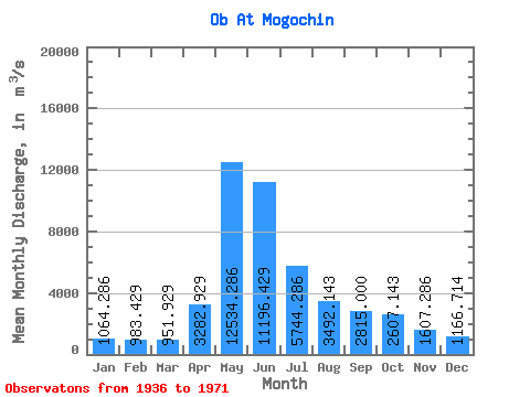
| Statistic | Jan | Feb | Mar | Apr | May | Jun | Jul | Aug | Sep | Oct | Nov | Dec | Annual |
|---|---|---|---|---|---|---|---|---|---|---|---|---|---|
| Mean | 1064.29 | 983.43 | 951.93 | 3282.93 | 12534.29 | 11196.43 | 5744.29 | 3492.14 | 2815.00 | 2607.14 | 1607.29 | 1166.71 | 3953.82 |
| Standard Deviation | 189.13 | 206.01 | 189.72 | 1913.57 | 2934.14 | 4925.71 | 1929.12 | 892.87 | 652.15 | 821.44 | 491.11 | 189.75 | 792.52 |
| Min | 775.00 | 643.00 | 601.00 | 841.00 | 8090.00 | 4500.00 | 2790.00 | 1800.00 | 1970.00 | 1620.00 | 962.00 | 918.00 | 2677.17 |
| Max | 1390.00 | 1460.00 | 1280.00 | 7020.00 | 17800.00 | 19500.00 | 8500.00 | 5590.00 | 4310.00 | 4670.00 | 2780.00 | 1480.00 | 5296.33 |
| Coefficient of Variation | 0.18 | 0.21 | 0.20 | 0.58 | 0.23 | 0.44 | 0.34 | 0.26 | 0.23 | 0.32 | 0.31 | 0.16 | 0.20 |
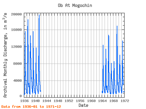
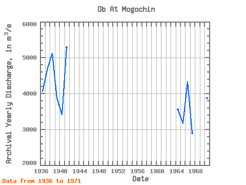
| Year | Jan | Feb | Mar | Apr | May | Jun | Jul | Aug | Sep | Oct | Nov | Dec | Annual | 1936 | 775.00 | 643.00 | 601.00 | 841.00 | 9340.00 | 15600.00 | 8160.00 | 4220.00 | 3760.00 | 2510.00 | 1210.00 | 1040.00 | 4058.33 | 1937 | 1120.00 | 951.00 | 801.00 | 1090.00 | 15300.00 | 18400.00 | 6520.00 | 3520.00 | 2470.00 | 3330.00 | 2110.00 | 1050.00 | 4721.83 | 1938 | 911.00 | 843.00 | 727.00 | 7020.00 | 14600.00 | 11100.00 | 7480.00 | 5590.00 | 4310.00 | 4670.00 | 2780.00 | 1340.00 | 5114.25 | 1939 | 1390.00 | 1130.00 | 962.00 | 4400.00 | 15600.00 | 7800.00 | 4980.00 | 3630.00 | 2360.00 | 1980.00 | 1110.00 | 1160.00 | 3875.17 | 1940 | 1060.00 | 807.00 | 764.00 | 4650.00 | 11700.00 | 7090.00 | 3890.00 | 2830.00 | 2750.00 | 2060.00 | 1780.00 | 1480.00 | 3405.08 | 1941 | 1250.00 | 1060.00 | 876.00 | 1780.00 | 17800.00 | 19500.00 | 7940.00 | 4340.00 | 3100.00 | 2710.00 | 1740.00 | 1460.00 | 5296.33 | 1964 | 1260.00 | 1460.00 | 1070.00 | 1090.00 | 12400.00 | 10200.00 | 4800.00 | 2830.00 | 2490.00 | 2280.00 | 1620.00 | 1100.00 | 3550.00 | 1965 | 1010.00 | 1040.00 | 1040.00 | 3820.00 | 11400.00 | 6850.00 | 2790.00 | 1800.00 | 2700.00 | 2720.00 | 1590.00 | 1210.00 | 3164.17 | 1966 | 1290.00 | 1210.00 | 1110.00 | 2230.00 | 14700.00 | 14200.00 | 8500.00 | 3250.00 | 1970.00 | 1620.00 | 962.00 | 918.00 | 4330.00 | 1967 | 932.00 | 855.00 | 883.00 | 3050.00 | 8090.00 | 4500.00 | 4190.00 | 3970.00 | 3400.00 | 2440.00 | 1490.00 | 987.00 | 2898.92 | 1968 | 851.00 | 797.00 | 1090.00 | 4140.00 | 8510.00 | 5210.00 | 2960.00 | 2740.00 | 2060.00 | 1770.00 | 1010.00 | 988.00 | 2677.17 | 1969 | 870.00 | 883.00 | 943.00 | 1730.00 | 13100.00 | 16900.00 | 7320.00 | 3540.00 | 3020.00 | 3520.00 | 1870.00 | 1400.00 | 4591.33 | 1970 | 1190.00 | 1100.00 | 1180.00 | 6000.00 | 9540.00 | 10000.00 | 5300.00 | 3450.00 | 2600.00 | 2980.00 | 1930.00 | 1220.00 | 3874.17 | 1971 | 991.00 | 989.00 | 1280.00 | 4120.00 | 13400.00 | 9400.00 | 5590.00 | 3180.00 | 2420.00 | 1910.00 | 1300.00 | 981.00 | 3796.75 |
|---|
 Return to R-Arctic Net Home Page