|
|
|||||||||||||||||
| Point ID: 6661 | Downloads | Plots | Site Data | Other Close Sites | Code: 10014 |
|
|
|||||||||||||||||
| Download | |
|---|---|
| Site Descriptor Information | Site Time Series Data |
| Link to all available data | |
| View: | Time Series | All |
| Units: | m3/s |
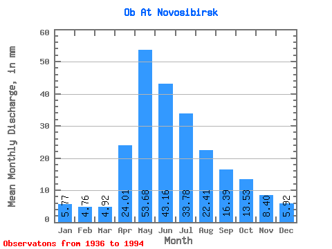
| Statistic | Jan | Feb | Mar | Apr | May | Jun | Jul | Aug | Sep | Oct | Nov | Dec | Annual |
|---|---|---|---|---|---|---|---|---|---|---|---|---|---|
| Mean | 5.77 | 4.80 | 4.92 | 24.01 | 53.68 | 43.16 | 33.77 | 22.40 | 16.39 | 13.52 | 8.40 | 5.92 | 239.90 |
| Standard Deviation | 2.63 | 2.75 | 2.87 | 11.06 | 16.02 | 12.03 | 12.60 | 6.85 | 5.26 | 4.32 | 3.33 | 1.29 | 43.78 |
| Min | 2.84 | 2.51 | 2.26 | 6.11 | 31.67 | 21.50 | 14.56 | 12.96 | 8.94 | 7.29 | 4.57 | 3.61 | 151.33 |
| Max | 14.66 | 12.59 | 13.92 | 52.46 | 100.74 | 64.18 | 58.34 | 42.19 | 30.86 | 28.27 | 15.53 | 8.16 | 321.10 |
| Coefficient of Variation | 0.46 | 0.57 | 0.58 | 0.46 | 0.30 | 0.28 | 0.37 | 0.31 | 0.32 | 0.32 | 0.40 | 0.22 | 0.18 |
| Other Close Sites | ||||||
|---|---|---|---|---|---|---|
| PointID | Latitude | Longitude | Drainage Area | Source | Name | |
| 6660 | "Ob At HPS Novosibirskaya" | 54.80 | -472892 | SHI | 2986.00 | |
| 6752 | "Inya (Nyzhnyaya) At Berezovka" | 55.00 | -445058 | SHI | 35.00 | |
 Return to R-Arctic Net Home Page