|
|
|||||||||||||||||
| Point ID: 6660 | Downloads | Plots | Site Data | Other Close Sites | Code: 10011 |
|
|
|||||||||||||||||
| Download | |
|---|---|
| Site Descriptor Information | Site Time Series Data |
| Link to all available data | |
| View: | Time Series | All |
| Units: | m3/s |
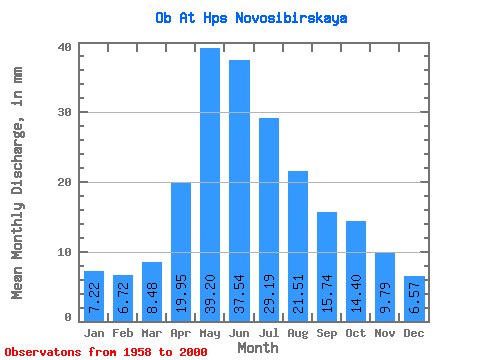
| Statistic | Jan | Feb | Mar | Apr | May | Jun | Jul | Aug | Sep | Oct | Nov | Dec | Annual |
|---|---|---|---|---|---|---|---|---|---|---|---|---|---|
| Mean | 7.22 | 6.78 | 8.48 | 19.95 | 39.20 | 37.54 | 29.19 | 21.51 | 15.74 | 14.40 | 9.79 | 6.57 | 215.84 |
| Standard Deviation | 1.63 | 1.50 | 1.60 | 6.96 | 13.62 | 12.05 | 10.93 | 7.54 | 3.33 | 3.41 | 1.97 | 1.17 | 41.20 |
| Min | 5.06 | 4.69 | 4.94 | 9.26 | 21.59 | 20.56 | 15.35 | 13.51 | 10.21 | 9.14 | 6.26 | 5.03 | 157.37 |
| Max | 12.93 | 10.34 | 12.81 | 34.41 | 79.88 | 78.21 | 57.72 | 45.59 | 23.69 | 23.09 | 13.85 | 10.56 | 316.88 |
| Coefficient of Variation | 0.23 | 0.22 | 0.19 | 0.35 | 0.35 | 0.32 | 0.37 | 0.35 | 0.21 | 0.24 | 0.20 | 0.18 | 0.19 |
| Other Close Sites | ||||||
|---|---|---|---|---|---|---|
| PointID | Latitude | Longitude | Drainage Area | Source | Name | |
| 6661 | "Ob At Novosibirsk" | 55.00 | -470289 | SHI | 2963.00 | |
| 6752 | "Inya (Nyzhnyaya) At Berezovka" | 55.00 | -445058 | SHI | 35.00 | |
 Return to R-Arctic Net Home Page