|
|
|||||||||||||||||
| Point ID: 666 | Downloads | Plots | Site Data | Code: 07BF004 |
|
|
|||||||||||||||||
| Download | |
|---|---|
| Site Descriptor Information | Site Time Series Data |
| Link to all available data | |
|
|
| View: | Statistics | Time Series |
| Units: | mm |
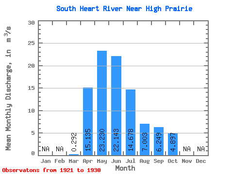
| Statistic | Jan | Feb | Mar | Apr | May | Jun | Jul | Aug | Sep | Oct | Nov | Dec | Annual |
|---|---|---|---|---|---|---|---|---|---|---|---|---|---|
| Mean | 0.29 | 15.13 | 23.23 | 22.14 | 14.68 | 7.00 | 6.25 | 4.90 | |||||
| Standard Deviation | 0.24 | 9.57 | 10.41 | 20.08 | 14.80 | 5.70 | 5.06 | 4.02 | |||||
| Min | 0.03 | 1.39 | 7.90 | 3.34 | 3.22 | 0.78 | 0.84 | 0.54 | |||||
| Max | 0.49 | 31.90 | 41.80 | 68.70 | 52.80 | 18.80 | 13.00 | 11.90 | |||||
| Coefficient of Variation | 0.82 | 0.63 | 0.45 | 0.91 | 1.01 | 0.81 | 0.81 | 0.82 |
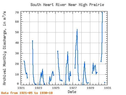
| Year | Jan | Feb | Mar | Apr | May | Jun | Jul | Aug | Sep | Oct | Nov | Dec | Annual | 1921 | 22.70 | 22.50 | 15.00 | 10.30 | 11.50 | 6.74 | 1922 | 41.80 | 11.20 | 3.22 | 0.78 | 0.84 | 0.72 | 1923 | 0.03 | 6.79 | 12.00 | 6.59 | 15.00 | 4.17 | 1.34 | 0.54 | 1924 | 1.39 | 7.90 | 3.34 | 4.86 | 9.93 | 13.00 | 9.12 | 1925 | 31.90 | 17.90 | 13.50 | 4.38 | 4.18 | 4.64 | 3.93 | 1926 | 0.49 | 19.90 | 20.70 | 31.60 | 6.97 | 3.41 | 12.90 | 8.79 | 1927 | 15.90 | 36.40 | 40.90 | 52.80 | 12.60 | 4.18 | 4.05 | 1928 | 0.36 | 11.80 | 21.90 | 10.00 | 6.05 | 1.94 | 1.69 | 1.91 | 1929 | 11.10 | 20.60 | 13.10 | 17.20 | 18.80 | 10.20 | 11.90 | 1930 | 22.30 | 30.40 | 68.70 | 21.30 | 3.92 | 2.20 | 1.27 |
|---|
 Return to R-Arctic Net Home Page