|
|
|||||||||||||||||
| Point ID: 6657 | Downloads | Plots | Site Data | Other Close Sites | Code: 10002 |
|
|
|||||||||||||||||
| Download | |
|---|---|
| Site Descriptor Information | Site Time Series Data |
| Link to all available data | |
|
|
| View: | Statistics | Time Series |
| Units: | mm |
| Statistic | Jan | Feb | Mar | Apr | May | Jun | Jul | Aug | Sep | Oct | Nov | Dec | Annual |
|---|---|---|---|---|---|---|---|---|---|---|---|---|---|
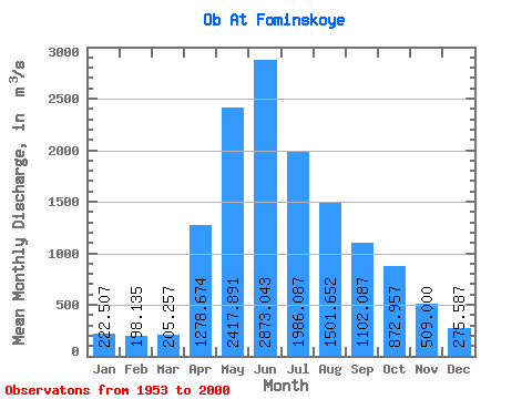
| Mean | 222.51 | 198.13 | 205.26 | 1278.67 | 2417.89 | 2873.04 | 1986.09 | 1501.65 | 1102.09 | 872.96 | 509.00 | 275.59 | 1120.24 |
| Standard Deviation | 51.11 | 51.35 | 49.16 | 375.01 | 587.01 | 899.65 | 614.38 | 482.70 | 310.37 | 258.14 | 141.17 | 66.29 | 196.88 |
| Min | 73.30 | 54.40 | 60.80 | 456.00 | 23.00 | 1580.00 | 1100.00 | 817.00 | 560.00 | 483.00 | 310.00 | 136.00 | 776.00 |
| Max | 368.00 | 310.00 | 310.00 | 2310.00 | 4340.00 | 5460.00 | 4150.00 | 3040.00 | 1930.00 | 1630.00 | 882.00 | 460.00 | 1655.83 |
| Coefficient of Variation | 0.23 | 0.26 | 0.24 | 0.29 | 0.24 | 0.31 | 0.31 | 0.32 | 0.28 | 0.30 | 0.28 | 0.24 | 0.18 |
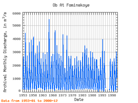
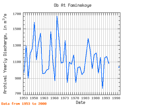
| Year | Jan | Feb | Mar | Apr | May | Jun | Jul | Aug | Sep | Oct | Nov | Dec | Annual | 1953 | 280.00 | 255.00 | 232.00 | 1450.00 | 2350.00 | 2670.00 | 1360.00 | 1060.00 | 778.00 | 621.00 | 323.00 | 247.00 | 968.83 | 1954 | 201.00 | 194.00 | 182.00 | 456.00 | 2340.00 | 4430.00 | 3030.00 | 1570.00 | 1330.00 | 714.00 | 620.00 | 460.00 | 1293.92 | 1955 | 213.00 | 183.00 | 198.00 | 1020.00 | 2710.00 | 2030.00 | 1100.00 | 928.00 | 978.00 | 805.00 | 432.00 | 247.00 | 903.67 | 1956 | 208.00 | 196.00 | 179.00 | 1100.00 | 2460.00 | 3700.00 | 2170.00 | 1410.00 | 1480.00 | 863.00 | 463.00 | 234.00 | 1205.25 | 1957 | 199.00 | 180.00 | 191.00 | 1240.00 | 2050.00 | 3910.00 | 2160.00 | 1700.00 | 1190.00 | 1020.00 | 882.00 | 396.00 | 1259.83 | 1958 | 285.00 | 232.00 | 227.00 | 1480.00 | 3040.00 | 3970.00 | 4150.00 | 2440.00 | 1420.00 | 912.00 | 525.00 | 271.00 | 1579.33 | 1959 | 251.00 | 233.00 | 231.00 | 1440.00 | 2610.00 | 2890.00 | 2260.00 | 1460.00 | 956.00 | 594.00 | 331.00 | 252.00 | 1125.67 | 1960 | 214.00 | 211.00 | 204.00 | 950.00 | 2300.00 | 3470.00 | 2900.00 | 2070.00 | 1740.00 | 970.00 | 561.00 | 327.00 | 1326.42 | 1961 | 303.00 | 310.00 | 303.00 | 2310.00 | 2100.00 | 3780.00 | 2400.00 | 1990.00 | 1700.00 | 1050.00 | 700.00 | 404.00 | 1445.83 | 1962 | 368.00 | 299.00 | 310.00 | 1590.00 | 2500.00 | 2180.00 | 1270.00 | 1020.00 | 695.00 | 618.00 | 366.00 | 239.00 | 954.58 | 1963 | 237.00 | 226.00 | 281.00 | 884.00 | 1960.00 | 2940.00 | 1590.00 | 997.00 | 777.00 | 655.00 | 680.00 | 310.00 | 961.42 | 1964 | 212.00 | 144.00 | 161.00 | 731.00 | 2350.00 | 2820.00 | 2050.00 | 1410.00 | 804.00 | 610.00 | 480.00 | 226.00 | 999.83 | 1965 | 266.00 | 225.00 | 214.00 | 1140.00 | 2980.00 | 1820.00 | 1390.00 | 1070.00 | 1340.00 | 926.00 | 539.00 | 265.00 | 1014.58 | 1966 | 240.00 | 208.00 | 233.00 | 1510.00 | 3530.00 | 5460.00 | 2550.00 | 1600.00 | 986.00 | 674.00 | 337.00 | 237.00 | 1463.75 | 1967 | 236.00 | 224.00 | 227.00 | 1310.00 | 1780.00 | 1870.00 | 1890.00 | 2680.00 | 1410.00 | 923.00 | 403.00 | 267.00 | 1101.67 | 1968 | 239.00 | 203.00 | 264.00 | 1010.00 | 2860.00 | 1730.00 | 1290.00 | 894.00 | 739.00 | 609.00 | 354.00 | 231.00 | 868.58 | 1969 | 175.00 | 141.00 | 128.00 | 1310.00 | 4340.00 | 4620.00 | 2730.00 | 1800.00 | 1930.00 | 1630.00 | 753.00 | 313.00 | 1655.83 | 1970 | 304.00 | 291.00 | 279.00 | 1670.00 | 3120.00 | 3490.00 | 2280.00 | 1750.00 | 1440.00 | 1140.00 | 535.00 | 327.00 | 1385.50 | 1971 | 252.00 | 197.00 | 173.00 | 1590.00 | 2660.00 | 2860.00 | 2200.00 | 1210.00 | 780.00 | 566.00 | 370.00 | 177.00 | 1086.25 | 1972 | 190.00 | 184.00 | 188.00 | 1420.00 | 2480.00 | 2690.00 | 2020.00 | 1400.00 | 1030.00 | 844.00 | 462.00 | 205.00 | 1092.75 | 1973 | 196.00 | 189.00 | 236.00 | 1830.00 | 2650.00 | 4320.00 | 2760.00 | 1600.00 | 1020.00 | 700.00 | 474.00 | 331.00 | 1358.83 | 1974 | 207.00 | 202.00 | 199.00 | 1690.00 | 1800.00 | 1700.00 | 1140.00 | 817.00 | 811.00 | 1080.00 | 360.00 | 184.00 | 849.17 | 1975 | 176.00 | 177.00 | 152.00 | 1110.00 | 2070.00 | 4230.00 | 1970.00 | 1180.00 | 761.00 | 817.00 | 310.00 | 184.00 | 1094.75 | 1976 | 189.00 | 178.00 | 167.00 | 972.00 | 2670.00 | 2350.00 | 1690.00 | 1880.00 | 968.00 | 1200.00 | 331.00 | 258.00 | 1071.08 | 1977 | 214.00 | 198.00 | 183.00 | 1820.00 | 2290.00 | 2700.00 | 1770.00 | 1680.00 | 1210.00 | 1200.00 | 645.00 | 277.00 | 1182.25 | 1978 | 230.00 | 225.00 | 235.00 | 1920.00 | 1710.00 | 1970.00 | 1150.00 | 1220.00 | 560.00 | 483.00 | 310.00 | 164.00 | 848.08 | 1979 | 196.00 | 199.00 | 200.00 | 957.00 | 2430.00 | 2530.00 | 1470.00 | 1100.00 | 1220.00 | 958.00 | 816.00 | 323.00 | 1033.25 | 1980 | 259.00 | 233.00 | 223.00 | 993.00 | 2500.00 | 2650.00 | 1900.00 | 1200.00 | 941.00 | 705.00 | 557.00 | 291.00 | 1037.67 | 1981 | 267.00 | 214.00 | 194.00 | 1440.00 | 2350.00 | 1840.00 | 1260.00 | 1120.00 | 1060.00 | 790.00 | 504.00 | 299.00 | 944.83 | 1982 | 246.00 | 198.00 | 199.00 | 1460.00 | 2360.00 | 2110.00 | 1330.00 | 1330.00 | 751.00 | 853.00 | 587.00 | 287.00 | 975.92 | 1983 | 239.00 | 233.00 | 183.00 | 913.00 | 2330.00 | 2960.00 | 2080.00 | 1750.00 | 1350.00 | 1060.00 | 693.00 | 327.00 | 1176.50 | 1984 | 246.00 | 216.00 | 222.00 | 803.00 | 2340.00 | 3480.00 | 3320.00 | 3040.00 | 1130.00 | 934.00 | 548.00 | 322.00 | 1383.42 | 1985 | 265.00 | 265.00 | 279.00 | 1380.00 | 2240.00 | 3260.00 | 2320.00 | 1770.00 | 1310.00 | 874.00 | 596.00 | 401.00 | 1246.67 | 1986 | 258.00 | 227.00 | 220.00 | 954.00 | 2580.00 | 2360.00 | 1790.00 | 1400.00 | 970.00 | 746.00 | 449.00 | 265.00 | 1018.25 | 1987 | 262.00 | 240.00 | 210.00 | 964.00 | 2860.00 | 3050.00 | 2090.00 | 1190.00 | 1060.00 | 1570.00 | 503.00 | 289.00 | 1190.67 | 1988 | 260.00 | 231.00 | 266.00 | 1290.00 | 2190.00 | 2960.00 | 2300.00 | 2240.00 | 1140.00 | 784.00 | 538.00 | 274.00 | 1206.08 | 1989 | 181.00 | 159.00 | 233.00 | 1080.00 | 2030.00 | 2480.00 | 2050.00 | 1200.00 | 700.00 | 644.00 | 510.00 | 277.00 | 962.00 | 1990 | 188.00 | 192.00 | 232.00 | 1130.00 | 2450.00 | 2290.00 | 1840.00 | 2410.00 | 1450.00 | 805.00 | 515.00 | 325.00 | 1152.25 | 1991 | 221.00 | 147.00 | 148.00 | 1170.00 | 23.00 | 1730.00 | 1670.00 | 1470.00 | 979.00 | 885.00 | 579.00 | 290.00 | 776.00 | 1992 | 213.00 | 173.00 | 202.00 | 1610.00 | 2350.00 | 2590.00 | 1710.00 | 1310.00 | 1610.00 | 1070.00 | 627.00 | 270.00 | 1144.58 | 1993 | 144.00 | 112.00 | 133.00 | 1410.00 | 2200.00 | 3940.00 | 2200.00 | 1350.00 | 1080.00 | 773.00 | 428.00 | 180.00 | 1162.50 | 1994 | 119.00 | 54.40 | 125.00 | 1290.00 | 3060.00 | 2400.00 | 1600.00 | 1260.00 | 1300.00 | 783.00 | 682.00 | 359.00 | 1086.03 | 1997 | 193.00 | 174.00 | 222.00 | 2050.00 | 2480.00 | 1580.00 | 1560.00 | 1340.00 | 967.00 | 627.00 | 318.00 | 230.00 | 978.42 | 1998 | 167.00 | 137.00 | 156.00 | 775.00 | 1900.00 | 2270.00 | 1580.00 | 1130.00 | 818.00 | 706.00 | 425.00 | 136.00 | 850.00 | 1999 | 73.30 | 57.80 | 60.80 | 897.00 | 2500.00 | 2060.00 | 1700.00 | 1520.00 | 1130.00 | 1570.00 | 622.00 | 234.00 | 1035.41 | 2000 | 153.00 | 147.00 | 157.00 | 1300.00 | 2340.00 | 3020.00 | 2320.00 | 1110.00 | 897.00 | 795.00 | 371.00 | 265.00 | 1072.92 |
|---|
| Other Close Sites | ||||||
|---|---|---|---|---|---|---|
| PointID | Latitude | Longitude | Drainage Area | Source | Name | |
| 6670 | "Biya At Biysk" | 52.55 | -336606 | SHI | 21.00 | |
 Return to R-Arctic Net Home Page