|
|
|||||||||||||||||
| Point ID: 6657 | Downloads | Plots | Site Data | Other Close Sites | Code: 10002 |
|
|
|||||||||||||||||
| Download | |
|---|---|
| Site Descriptor Information | Site Time Series Data |
| Link to all available data | |
| View: | Time Series | All |
| Units: | mm |
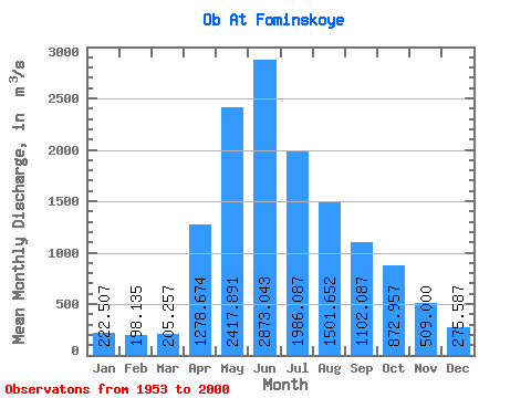
| Statistic | Jan | Feb | Mar | Apr | May | Jun | Jul | Aug | Sep | Oct | Nov | Dec | Annual |
|---|---|---|---|---|---|---|---|---|---|---|---|---|---|
| Mean | 222.51 | 198.13 | 205.26 | 1278.67 | 2417.89 | 2873.04 | 1986.09 | 1501.65 | 1102.09 | 872.96 | 509.00 | 275.59 | 1120.24 |
| Standard Deviation | 51.11 | 51.35 | 49.16 | 375.01 | 587.01 | 899.65 | 614.38 | 482.70 | 310.37 | 258.14 | 141.17 | 66.29 | 196.88 |
| Min | 73.30 | 54.40 | 60.80 | 456.00 | 23.00 | 1580.00 | 1100.00 | 817.00 | 560.00 | 483.00 | 310.00 | 136.00 | 776.00 |
| Max | 368.00 | 310.00 | 310.00 | 2310.00 | 4340.00 | 5460.00 | 4150.00 | 3040.00 | 1930.00 | 1630.00 | 882.00 | 460.00 | 1655.83 |
| Coefficient of Variation | 0.23 | 0.26 | 0.24 | 0.29 | 0.24 | 0.31 | 0.31 | 0.32 | 0.28 | 0.30 | 0.28 | 0.24 | 0.18 |
| Other Close Sites | ||||||
|---|---|---|---|---|---|---|
| PointID | Latitude | Longitude | Drainage Area | Source | Name | |
| 6670 | "Biya At Biysk" | 52.55 | -336606 | SHI | 21.00 | |
 Return to R-Arctic Net Home Page