|
|
|||||||||||||||||
| Point ID: 6651 | Downloads | Plots | Site Data | Code: 9523 |
|
|
|||||||||||||||||
| Download | |
|---|---|
| Site Descriptor Information | Site Time Series Data |
| Link to all available data | |
|
|
| View: | Statistics | Time Series |
| Units: | mm |
| Statistic | Jan | Feb | Mar | Apr | May | Jun | Jul | Aug | Sep | Oct | Nov | Dec | Annual |
|---|---|---|---|---|---|---|---|---|---|---|---|---|---|
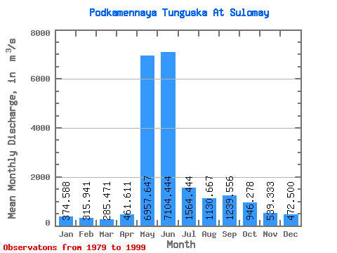
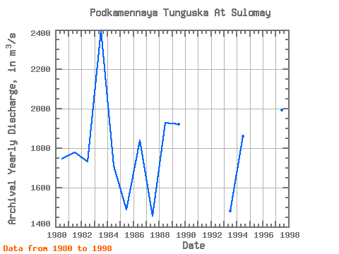
| Mean | 374.59 | 315.94 | 285.47 | 461.61 | 6957.65 | 7104.44 | 1564.44 | 1130.67 | 1239.56 | 946.28 | 539.33 | 472.50 | 1808.38 |
| Standard Deviation | 80.45 | 57.59 | 48.08 | 704.96 | 2023.05 | 3203.16 | 368.90 | 361.31 | 488.99 | 377.17 | 143.88 | 117.25 | 241.82 |
| Min | 271.00 | 232.00 | 205.00 | 222.00 | 3520.00 | 3020.00 | 1110.00 | 639.00 | 625.00 | 410.00 | 329.00 | 305.00 | 1455.83 |
| Max | 525.00 | 436.00 | 375.00 | 3270.00 | 10200.00 | 17300.00 | 2330.00 | 1890.00 | 2290.00 | 1740.00 | 808.00 | 704.00 | 2396.67 |
| Coefficient of Variation | 0.21 | 0.18 | 0.17 | 1.53 | 0.29 | 0.45 | 0.24 | 0.32 | 0.39 | 0.40 | 0.27 | 0.25 | 0.13 |
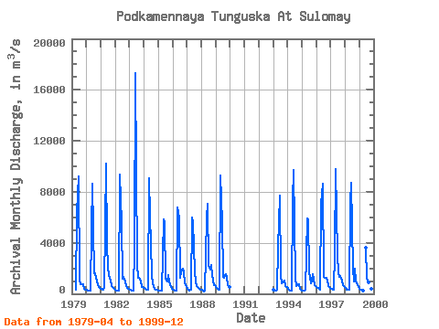
| Year | Jan | Feb | Mar | Apr | May | Jun | Jul | Aug | Sep | Oct | Nov | Dec | Annual | 1979 | 290.00 | 6400.00 | 9220.00 | 1110.00 | 720.00 | 736.00 | 777.00 | 398.00 | 323.00 | 1980 | 304.00 | 284.00 | 245.00 | 222.00 | 5050.00 | 8650.00 | 1640.00 | 1620.00 | 1260.00 | 702.00 | 522.00 | 465.00 | 1747.00 | 1981 | 362.00 | 344.00 | 308.00 | 567.00 | 10200.00 | 3990.00 | 1940.00 | 1170.00 | 1020.00 | 593.00 | 437.00 | 388.00 | 1776.58 | 1982 | 292.00 | 232.00 | 218.00 | 253.00 | 9350.00 | 5540.00 | 1210.00 | 1330.00 | 946.00 | 581.00 | 435.00 | 389.00 | 1731.33 | 1983 | 332.00 | 310.00 | 276.00 | 230.00 | 3520.00 | 17300.00 | 2330.00 | 1250.00 | 1220.00 | 940.00 | 537.00 | 515.00 | 2396.67 | 1984 | 457.00 | 367.00 | 313.00 | 289.00 | 9080.00 | 6100.00 | 1520.00 | 742.00 | 625.00 | 410.00 | 329.00 | 305.00 | 1711.42 | 1985 | 271.00 | 241.00 | 217.00 | 246.00 | 5820.00 | 5590.00 | 1150.00 | 947.00 | 1490.00 | 965.00 | 509.00 | 411.00 | 1488.08 | 1986 | 330.00 | 289.00 | 280.00 | 262.00 | 6800.00 | 5990.00 | 1280.00 | 1760.00 | 1970.00 | 1740.00 | 808.00 | 577.00 | 1840.50 | 1987 | 410.00 | 314.00 | 281.00 | 316.00 | 6000.00 | 5600.00 | 1790.00 | 966.00 | 625.00 | 484.00 | 369.00 | 315.00 | 1455.83 | 1988 | 294.00 | 249.00 | 205.00 | 235.00 | 5890.00 | 7060.00 | 2190.00 | 1890.00 | 2290.00 | 1460.00 | 660.00 | 704.00 | 1927.25 | 1989 | 525.00 | 398.00 | 355.00 | 339.00 | 9300.00 | 5620.00 | 1300.00 | 1220.00 | 1520.00 | 1290.00 | 652.00 | 547.00 | 1922.17 | 1993 | 313.00 | 280.00 | 277.00 | 301.00 | 3640.00 | 7680.00 | 1380.00 | 819.00 | 922.00 | 1050.00 | 581.00 | 546.00 | 1482.42 | 1994 | 395.00 | 288.00 | 270.00 | 264.00 | 7360.00 | 9730.00 | 1250.00 | 639.00 | 647.00 | 755.00 | 377.00 | 340.00 | 1859.58 | 1995 | 285.00 | 268.00 | 272.00 | 307.00 | 5930.00 | 5800.00 | 1750.00 | 852.00 | 981.00 | 1560.00 | 704.00 | 620.00 | 1610.75 | 1996 | 511.00 | 436.00 | 375.00 | 325.00 | 7080.00 | 8620.00 | 1340.00 | 1290.00 | 1290.00 | 1050.00 | 622.00 | 494.00 | 1952.75 | 1997 | 423.00 | 367.00 | 339.00 | 3270.00 | 9760.00 | 3020.00 | 1720.00 | 1300.00 | 1400.00 | 1020.00 | 703.00 | 584.00 | 1992.17 | 1998 | 440.00 | 355.00 | 330.00 | 315.00 | 7100.00 | 8720.00 | 1970.00 | 954.00 | 2000.00 | 1040.00 | 687.00 | 563.00 | 2039.50 | 1999 | 424.00 | 349.00 | 292.00 | 278.00 | 3650.00 | 1290.00 | 883.00 | 1370.00 | 616.00 | 378.00 | 419.00 |
|---|
 Return to R-Arctic Net Home Page