|
|
|||||||||||||||||
| Point ID: 6580 | Downloads | Plots | Site Data | Code: 9279 |
|
|
|||||||||||||||||
| Download | |
|---|---|
| Site Descriptor Information | Site Time Series Data |
| Link to all available data | |
|
|
| View: | Statistics | Time Series |
| Units: | mm |
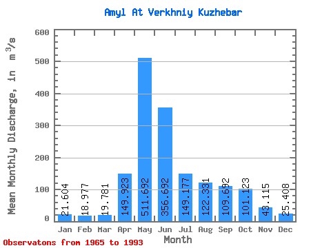
| Statistic | Jan | Feb | Mar | Apr | May | Jun | Jul | Aug | Sep | Oct | Nov | Dec | Annual |
|---|---|---|---|---|---|---|---|---|---|---|---|---|---|
| Mean | 21.60 | 18.98 | 19.78 | 149.92 | 511.69 | 356.69 | 149.18 | 122.33 | 109.69 | 101.12 | 43.12 | 25.41 | 135.79 |
| Standard Deviation | 4.24 | 2.61 | 3.60 | 68.23 | 134.44 | 187.11 | 58.59 | 52.99 | 55.25 | 49.87 | 17.28 | 5.75 | 25.76 |
| Min | 14.30 | 15.50 | 14.20 | 25.30 | 290.00 | 132.00 | 56.50 | 36.10 | 51.50 | 41.90 | 24.20 | 14.00 | 89.10 |
| Max | 30.10 | 25.70 | 29.10 | 270.00 | 822.00 | 903.00 | 305.00 | 215.00 | 310.00 | 252.00 | 82.70 | 38.40 | 192.88 |
| Coefficient of Variation | 0.20 | 0.14 | 0.18 | 0.46 | 0.26 | 0.53 | 0.39 | 0.43 | 0.50 | 0.49 | 0.40 | 0.23 | 0.19 |
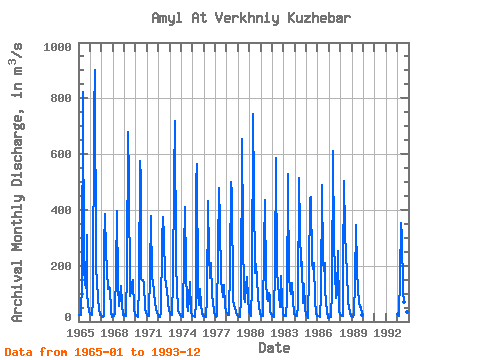
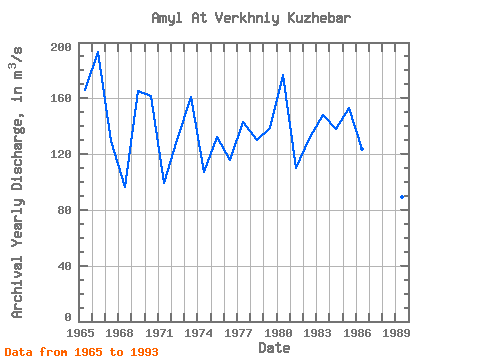
| Year | Jan | Feb | Mar | Apr | May | Jun | Jul | Aug | Sep | Oct | Nov | Dec | Annual | 1965 | 24.80 | 22.60 | 23.00 | 149.00 | 822.00 | 191.00 | 135.00 | 121.00 | 310.00 | 94.70 | 66.90 | 34.80 | 166.23 | 1966 | 28.40 | 25.70 | 24.40 | 76.70 | 747.00 | 903.00 | 189.00 | 147.00 | 77.20 | 47.30 | 24.20 | 24.60 | 192.88 | 1967 | 17.30 | 16.80 | 21.50 | 269.00 | 385.00 | 253.00 | 182.00 | 116.00 | 123.00 | 121.00 | 33.40 | 17.40 | 129.62 | 1968 | 19.20 | 18.50 | 29.10 | 183.00 | 396.00 | 132.00 | 56.50 | 83.40 | 128.00 | 63.10 | 25.00 | 25.60 | 96.62 | 1969 | 20.40 | 18.20 | 18.60 | 186.00 | 679.00 | 507.00 | 90.00 | 107.00 | 139.00 | 150.00 | 41.00 | 25.30 | 165.12 | 1970 | 20.10 | 18.00 | 15.80 | 135.00 | 575.00 | 512.00 | 153.00 | 149.00 | 149.00 | 135.00 | 47.70 | 29.10 | 161.56 | 1971 | 23.80 | 19.70 | 19.40 | 179.00 | 378.00 | 157.00 | 142.00 | 105.00 | 65.80 | 47.10 | 28.70 | 23.10 | 99.05 | 1972 | 17.70 | 16.70 | 21.40 | 25.30 | 290.00 | 373.00 | 305.00 | 160.00 | 130.00 | 113.00 | 71.40 | 38.40 | 130.16 | 1973 | 30.10 | 23.20 | 24.00 | 146.00 | 516.00 | 719.00 | 218.00 | 104.00 | 56.30 | 41.90 | 29.50 | 24.80 | 161.07 | 1974 | 20.60 | 18.10 | 16.40 | 252.00 | 409.00 | 188.00 | 61.90 | 36.10 | 84.80 | 141.00 | 37.50 | 21.50 | 107.24 | 1975 | 21.50 | 18.00 | 17.60 | 70.10 | 498.00 | 566.00 | 103.00 | 59.30 | 116.00 | 63.60 | 30.50 | 20.50 | 132.01 | 1976 | 18.50 | 15.80 | 14.40 | 80.80 | 433.00 | 242.00 | 155.00 | 210.00 | 93.40 | 69.70 | 32.70 | 23.30 | 115.72 | 1977 | 18.40 | 16.50 | 18.90 | 251.00 | 478.00 | 360.00 | 146.00 | 116.00 | 87.40 | 132.00 | 55.50 | 33.30 | 142.75 | 1978 | 30.00 | 24.00 | 24.00 | 198.00 | 500.00 | 456.00 | 86.20 | 80.60 | 55.00 | 48.80 | 34.80 | 22.40 | 129.98 | 1979 | 18.50 | 17.00 | 16.80 | 79.10 | 654.00 | 323.00 | 83.20 | 70.60 | 126.00 | 160.00 | 82.70 | 32.80 | 138.64 | 1980 | 27.30 | 21.10 | 19.00 | 130.00 | 742.00 | 473.00 | 175.00 | 205.00 | 151.00 | 88.20 | 54.50 | 30.40 | 176.38 | 1981 | 20.90 | 18.70 | 20.30 | 270.00 | 436.00 | 140.00 | 84.80 | 74.30 | 103.00 | 90.40 | 37.00 | 27.00 | 110.20 | 1982 | 21.50 | 19.30 | 16.80 | 204.00 | 585.00 | 186.00 | 126.00 | 97.50 | 53.20 | 163.00 | 69.90 | 29.90 | 131.01 | 1983 | 21.30 | 19.40 | 20.60 | 75.40 | 529.00 | 494.00 | 159.00 | 117.00 | 100.00 | 137.00 | 76.00 | 28.60 | 148.11 | 1984 | 21.90 | 19.50 | 21.30 | 58.40 | 513.00 | 329.00 | 200.00 | 215.00 | 64.80 | 136.00 | 49.70 | 24.50 | 137.76 | 1985 | 19.60 | 16.50 | 14.20 | 173.00 | 438.00 | 447.00 | 210.00 | 188.00 | 210.00 | 72.20 | 29.80 | 20.80 | 153.26 | 1986 | 18.40 | 18.20 | 16.90 | 94.20 | 488.00 | 219.00 | 182.00 | 210.00 | 114.00 | 70.40 | 34.90 | 14.00 | 123.33 | 1987 | 14.30 | 16.30 | 15.60 | 112.00 | 612.00 | 283.00 | 182.00 | 83.40 | 98.60 | 252.00 | 37.40 | 28.60 | 144.60 | 1988 | 24.30 | 19.40 | 18.40 | 193.00 | 502.00 | 329.00 | 232.00 | 186.00 | 71.50 | 52.50 | 31.00 | 18.40 | 139.79 | 1989 | 15.80 | 15.50 | 22.90 | 148.00 | 345.00 | 189.00 | 112.00 | 69.00 | 51.50 | 51.70 | 26.90 | 21.90 | 89.10 | 1993 | 27.10 | 20.70 | 23.00 | 160.00 | 354.00 | 303.00 | 110.00 | 70.40 | 93.50 | 87.60 | 32.40 | 19.60 | 108.44 |
|---|
 Return to R-Arctic Net Home Page