|
|
|||||||||||||||||
| Point ID: 6580 | Downloads | Plots | Site Data | Code: 9279 |
|
|
|||||||||||||||||
| Download | |
|---|---|
| Site Descriptor Information | Site Time Series Data |
| Link to all available data | |
|
|
| View: | Statistics | Time Series |
| Units: | m3/s |
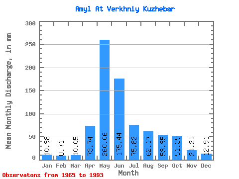
| Statistic | Jan | Feb | Mar | Apr | May | Jun | Jul | Aug | Sep | Oct | Nov | Dec | Annual |
|---|---|---|---|---|---|---|---|---|---|---|---|---|---|
| Mean | 10.98 | 8.79 | 10.05 | 73.74 | 260.02 | 175.44 | 75.81 | 62.16 | 53.95 | 51.39 | 21.21 | 12.91 | 813.21 |
| Standard Deviation | 2.15 | 1.21 | 1.83 | 33.56 | 68.31 | 92.03 | 29.77 | 26.93 | 27.18 | 25.34 | 8.50 | 2.92 | 154.26 |
| Min | 7.27 | 7.18 | 7.22 | 12.44 | 147.37 | 64.92 | 28.71 | 18.34 | 25.33 | 21.29 | 11.90 | 7.11 | 533.59 |
| Max | 15.30 | 11.90 | 14.79 | 132.80 | 417.71 | 444.13 | 154.99 | 109.25 | 152.47 | 128.06 | 40.67 | 19.51 | 1155.05 |
| Coefficient of Variation | 0.20 | 0.14 | 0.18 | 0.46 | 0.26 | 0.53 | 0.39 | 0.43 | 0.50 | 0.49 | 0.40 | 0.23 | 0.19 |
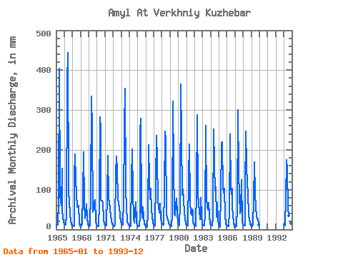
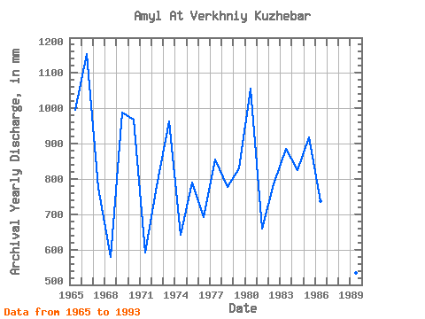
| Year | Jan | Feb | Mar | Apr | May | Jun | Jul | Aug | Sep | Oct | Nov | Dec | Annual | 1965 | 12.60 | 10.46 | 11.69 | 73.28 | 417.71 | 93.94 | 68.60 | 61.49 | 152.47 | 48.12 | 32.90 | 17.68 | 995.51 | 1966 | 14.43 | 11.90 | 12.40 | 37.72 | 379.60 | 444.13 | 96.04 | 74.70 | 37.97 | 24.04 | 11.90 | 12.50 | 1155.05 | 1967 | 8.79 | 7.78 | 10.93 | 132.31 | 195.64 | 124.44 | 92.48 | 58.95 | 60.50 | 61.49 | 16.43 | 8.84 | 776.22 | 1968 | 9.76 | 8.56 | 14.79 | 90.01 | 201.23 | 64.92 | 28.71 | 42.38 | 62.96 | 32.06 | 12.30 | 13.01 | 578.60 | 1969 | 10.37 | 8.43 | 9.45 | 91.48 | 345.04 | 249.36 | 45.73 | 54.37 | 68.37 | 76.22 | 20.16 | 12.86 | 988.87 | 1970 | 10.21 | 8.33 | 8.03 | 66.40 | 292.19 | 251.82 | 77.75 | 75.72 | 73.28 | 68.60 | 23.46 | 14.79 | 967.51 | 1971 | 12.09 | 9.12 | 9.86 | 88.04 | 192.08 | 77.22 | 72.16 | 53.36 | 32.36 | 23.93 | 14.12 | 11.74 | 593.17 | 1972 | 8.99 | 7.73 | 10.88 | 12.44 | 147.37 | 183.46 | 154.99 | 81.31 | 63.94 | 57.42 | 35.12 | 19.51 | 779.47 | 1973 | 15.30 | 10.74 | 12.20 | 71.81 | 262.21 | 353.63 | 110.78 | 52.85 | 27.69 | 21.29 | 14.51 | 12.60 | 964.57 | 1974 | 10.47 | 8.38 | 8.33 | 123.94 | 207.84 | 92.47 | 31.45 | 18.34 | 41.71 | 71.65 | 18.44 | 10.93 | 642.23 | 1975 | 10.93 | 8.33 | 8.94 | 34.48 | 253.06 | 278.38 | 52.34 | 30.13 | 57.05 | 32.32 | 15.00 | 10.42 | 790.55 | 1976 | 9.40 | 7.32 | 7.32 | 39.74 | 220.03 | 119.03 | 78.77 | 106.71 | 45.94 | 35.42 | 16.08 | 11.84 | 692.98 | 1977 | 9.35 | 7.64 | 9.60 | 123.45 | 242.90 | 177.06 | 74.19 | 58.95 | 42.99 | 67.08 | 27.30 | 16.92 | 854.88 | 1978 | 15.24 | 11.11 | 12.20 | 97.38 | 254.08 | 224.28 | 43.80 | 40.96 | 27.05 | 24.80 | 17.12 | 11.38 | 778.42 | 1979 | 9.40 | 7.87 | 8.54 | 38.91 | 332.34 | 158.87 | 42.28 | 35.88 | 61.97 | 81.31 | 40.67 | 16.67 | 830.27 | 1980 | 13.87 | 9.77 | 9.65 | 63.94 | 377.05 | 232.64 | 88.93 | 104.17 | 74.27 | 44.82 | 26.80 | 15.45 | 1056.24 | 1981 | 10.62 | 8.66 | 10.32 | 132.80 | 221.56 | 68.86 | 43.09 | 37.76 | 50.66 | 45.94 | 18.20 | 13.72 | 659.95 | 1982 | 10.93 | 8.94 | 8.54 | 100.33 | 297.27 | 91.48 | 64.03 | 49.55 | 26.17 | 82.83 | 34.38 | 15.19 | 784.56 | 1983 | 10.82 | 8.98 | 10.47 | 37.09 | 268.82 | 242.97 | 80.80 | 59.45 | 49.18 | 69.62 | 37.38 | 14.53 | 886.96 | 1984 | 11.13 | 9.03 | 10.82 | 28.72 | 260.69 | 161.82 | 101.63 | 109.25 | 31.87 | 69.11 | 24.44 | 12.45 | 824.98 | 1985 | 9.96 | 7.64 | 7.22 | 85.09 | 222.57 | 219.85 | 106.71 | 95.53 | 103.29 | 36.69 | 14.66 | 10.57 | 917.80 | 1986 | 9.35 | 8.43 | 8.59 | 46.33 | 247.98 | 107.71 | 92.48 | 106.71 | 56.07 | 35.77 | 17.16 | 7.11 | 738.60 | 1987 | 7.27 | 7.55 | 7.93 | 55.09 | 310.99 | 139.19 | 92.48 | 42.38 | 48.49 | 128.06 | 18.39 | 14.53 | 865.95 | 1988 | 12.35 | 8.98 | 9.35 | 94.92 | 255.10 | 161.82 | 117.89 | 94.52 | 35.17 | 26.68 | 15.25 | 9.35 | 837.16 | 1989 | 8.03 | 7.18 | 11.64 | 72.79 | 175.31 | 92.96 | 56.91 | 35.06 | 25.33 | 26.27 | 13.23 | 11.13 | 533.59 | 1993 | 13.77 | 9.58 | 11.69 | 78.69 | 179.89 | 149.03 | 55.90 | 35.77 | 45.99 | 44.52 | 15.94 | 9.96 | 649.41 |
|---|
 Return to R-Arctic Net Home Page