|
|
|||||||||||||||||
| Point ID: 658 | Downloads | Plots | Site Data | Code: 07BC004 |
|
|
|||||||||||||||||
| Download | |
|---|---|
| Site Descriptor Information | Site Time Series Data |
| Link to all available data | |
| View: | Time Series | All |
| Units: | m3/s |
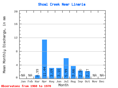
| Statistic | Jan | Feb | Mar | Apr | May | Jun | Jul | Aug | Sep | Oct | Nov | Dec | Annual |
|---|---|---|---|---|---|---|---|---|---|---|---|---|---|
| Mean | 0.92 | 10.69 | 2.89 | 2.90 | 5.59 | 3.42 | 2.15 | 2.03 | |||||
| Standard Deviation | 1.29 | 9.11 | 3.82 | 2.15 | 8.81 | 3.96 | 3.70 | 2.07 | |||||
| Min | 0.00 | 0.14 | 0.04 | 0.02 | 0.05 | 0.00 | 0.00 | 0.00 | |||||
| Max | 3.27 | 28.21 | 12.54 | 6.10 | 26.96 | 12.48 | 11.79 | 6.18 | |||||
| Coefficient of Variation | 1.40 | 0.85 | 1.32 | 0.74 | 1.57 | 1.16 | 1.72 | 1.02 |
 Return to R-Arctic Net Home Page