|
|
|||||||||||||||||
| Point ID: 658 | Downloads | Plots | Site Data | Code: 07BC004 |
|
|
|||||||||||||||||
| Download | |
|---|---|
| Site Descriptor Information | Site Time Series Data |
| Link to all available data | |
| View: | Time Series | All |
| Units: | mm |
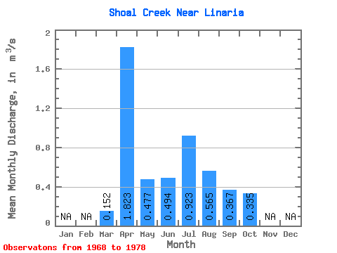
| Statistic | Jan | Feb | Mar | Apr | May | Jun | Jul | Aug | Sep | Oct | Nov | Dec | Annual |
|---|---|---|---|---|---|---|---|---|---|---|---|---|---|
| Mean | 0.15 | 1.82 | 0.48 | 0.49 | 0.92 | 0.56 | 0.37 | 0.34 | |||||
| Standard Deviation | 0.21 | 1.55 | 0.63 | 0.37 | 1.45 | 0.65 | 0.63 | 0.34 | |||||
| Min | 0.00 | 0.02 | 0.01 | 0.00 | 0.01 | 0.00 | 0.00 | 0.00 | |||||
| Max | 0.54 | 4.81 | 2.07 | 1.04 | 4.45 | 2.06 | 2.01 | 1.02 | |||||
| Coefficient of Variation | 1.40 | 0.85 | 1.32 | 0.74 | 1.57 | 1.16 | 1.72 | 1.02 |
 Return to R-Arctic Net Home Page