|
|
|||||||||||||||||
| Point ID: 6549 | Downloads | Plots | Site Data | Code: 9117 |
|
|
|||||||||||||||||
| Download | |
|---|---|
| Site Descriptor Information | Site Time Series Data |
| Link to all available data | |
|
|
| View: | Statistics | Time Series |
| Units: | mm |
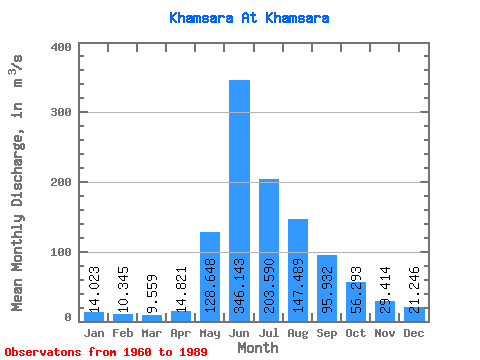
| Statistic | Jan | Feb | Mar | Apr | May | Jun | Jul | Aug | Sep | Oct | Nov | Dec | Annual |
|---|---|---|---|---|---|---|---|---|---|---|---|---|---|
| Mean | 14.02 | 10.35 | 9.56 | 14.82 | 128.65 | 346.14 | 203.59 | 147.49 | 95.93 | 56.29 | 29.41 | 21.25 | 89.83 |
| Standard Deviation | 2.56 | 3.82 | 3.36 | 5.46 | 56.55 | 83.57 | 59.08 | 44.95 | 24.07 | 15.30 | 8.64 | 4.71 | 12.34 |
| Min | 10.10 | 6.84 | 5.09 | 7.93 | 45.70 | 225.00 | 91.10 | 76.30 | 55.10 | 30.70 | 16.70 | 11.70 | 70.53 |
| Max | 19.20 | 26.20 | 21.50 | 31.70 | 258.00 | 560.00 | 357.00 | 248.00 | 165.00 | 114.00 | 46.10 | 31.60 | 113.07 |
| Coefficient of Variation | 0.18 | 0.37 | 0.35 | 0.37 | 0.44 | 0.24 | 0.29 | 0.30 | 0.25 | 0.27 | 0.29 | 0.22 | 0.14 |
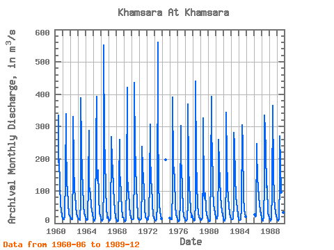
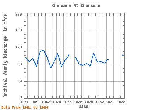
| Year | Jan | Feb | Mar | Apr | May | Jun | Jul | Aug | Sep | Oct | Nov | Dec | Annual | 1960 | 335.00 | 188.00 | 196.00 | 120.00 | 56.60 | 39.00 | 22.00 | 1961 | 13.90 | 11.00 | 11.20 | 19.60 | 146.00 | 339.00 | 256.00 | 119.00 | 107.00 | 62.00 | 29.50 | 23.50 | 94.81 | 1962 | 17.40 | 13.70 | 12.00 | 12.90 | 167.00 | 331.00 | 183.00 | 99.50 | 89.90 | 53.60 | 28.20 | 22.30 | 85.88 | 1963 | 16.30 | 12.80 | 11.30 | 10.50 | 73.00 | 388.00 | 242.00 | 152.00 | 119.00 | 52.10 | 33.50 | 21.70 | 94.35 | 1964 | 17.40 | 10.70 | 8.73 | 12.20 | 123.00 | 288.00 | 117.00 | 101.00 | 91.30 | 54.60 | 38.90 | 26.10 | 74.08 | 1965 | 13.20 | 7.78 | 8.33 | 15.40 | 258.00 | 392.00 | 179.00 | 132.00 | 165.00 | 80.80 | 29.40 | 24.30 | 108.77 | 1966 | 16.50 | 7.53 | 7.62 | 13.10 | 113.00 | 552.00 | 249.00 | 206.00 | 101.00 | 53.20 | 16.70 | 21.20 | 113.07 | 1967 | 12.90 | 7.29 | 8.86 | 17.20 | 238.00 | 268.00 | 193.00 | 167.00 | 112.00 | 68.50 | 42.90 | 18.90 | 96.21 | 1968 | 10.90 | 6.91 | 5.56 | 7.93 | 125.00 | 259.00 | 118.00 | 142.00 | 82.50 | 50.90 | 19.30 | 18.40 | 70.53 | 1969 | 13.80 | 7.26 | 6.18 | 12.00 | 131.00 | 420.00 | 156.00 | 98.30 | 97.90 | 50.30 | 32.00 | 16.40 | 86.76 | 1970 | 11.90 | 11.00 | 11.50 | 14.60 | 160.00 | 436.00 | 227.00 | 184.00 | 104.00 | 74.30 | 17.90 | 11.70 | 105.33 | 1971 | 11.60 | 10.50 | 12.00 | 14.70 | 117.00 | 237.00 | 168.00 | 146.00 | 99.30 | 45.10 | 17.80 | 15.10 | 74.51 | 1972 | 12.60 | 10.70 | 11.60 | 31.70 | 126.00 | 306.00 | 220.00 | 126.00 | 117.00 | 61.70 | 23.70 | 16.90 | 88.66 | 1973 | 12.20 | 9.67 | 7.19 | 12.70 | 54.80 | 560.00 | 297.00 | 127.00 | 55.10 | 38.50 | 21.60 | 13.10 | 100.74 | 1974 | 197.00 | 1975 | 16.60 | 13.40 | 11.70 | 11.00 | 109.00 | 390.00 | 182.00 | 167.00 | 136.00 | 54.80 | 27.00 | 20.30 | 94.90 | 1976 | 12.90 | 7.82 | 6.26 | 9.67 | 68.70 | 302.00 | 190.00 | 172.00 | 107.00 | 47.10 | 20.30 | 17.70 | 80.12 | 1977 | 10.10 | 7.07 | 7.99 | 12.80 | 63.60 | 368.00 | 166.00 | 120.00 | 78.10 | 46.20 | 18.50 | 24.70 | 76.92 | 1978 | 17.40 | 11.00 | 8.57 | 9.13 | 68.20 | 439.00 | 193.00 | 121.00 | 56.40 | 30.70 | 19.10 | 15.00 | 82.38 | 1979 | 10.50 | 10.50 | 11.80 | 19.00 | 166.00 | 326.00 | 91.10 | 76.30 | 94.40 | 46.90 | 27.40 | 18.50 | 74.87 | 1980 | 10.80 | 6.84 | 5.09 | 8.34 | 154.00 | 392.00 | 193.00 | 248.00 | 103.00 | 60.20 | 43.90 | 31.60 | 104.73 | 1981 | 19.20 | 13.50 | 13.70 | 26.00 | 168.00 | 259.00 | 181.00 | 131.00 | 87.50 | 53.90 | 36.60 | 26.50 | 84.66 | 1982 | 14.70 | 8.35 | 8.11 | 16.20 | 144.00 | 344.00 | 199.00 | 115.00 | 75.90 | 54.80 | 30.00 | 21.50 | 85.96 | 1983 | 13.20 | 10.80 | 11.00 | 13.30 | 57.40 | 281.00 | 242.00 | 146.00 | 81.60 | 62.60 | 46.10 | 25.80 | 82.57 | 1984 | 12.40 | 9.76 | 9.51 | 11.30 | 45.70 | 286.00 | 305.00 | 239.00 | 82.70 | 39.80 | 30.90 | 21.20 | 91.11 | 1986 | 26.20 | 21.50 | 21.80 | 247.00 | 225.00 | 141.00 | 110.00 | 81.80 | 58.00 | 40.40 | 28.60 | 1987 | 15.40 | 7.59 | 6.64 | 20.70 | 119.00 | 335.00 | 288.00 | 229.00 | 110.00 | 114.00 | 28.40 | 24.50 | 108.19 | 1988 | 17.50 | 10.90 | 7.28 | 12.10 | 98.10 | 365.00 | 357.00 | 163.00 | 73.60 | 54.80 | 31.00 | 22.50 | 101.06 | 1989 | 13.30 | 8.75 | 6.88 | 14.30 | 133.00 | 269.00 | 186.00 | 96.60 | 57.10 | 50.20 | 33.60 | 24.90 | 74.47 |
|---|
 Return to R-Arctic Net Home Page