|
|
|||||||||||||||||
| Point ID: 6549 | Downloads | Plots | Site Data | Code: 9117 |
|
|
|||||||||||||||||
| Download | |
|---|---|
| Site Descriptor Information | Site Time Series Data |
| Link to all available data | |
|
|
| View: | Statistics | Time Series |
| Units: | m3/s |
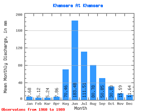
| Statistic | Jan | Feb | Mar | Apr | May | Jun | Jul | Aug | Sep | Oct | Nov | Dec | Annual |
|---|---|---|---|---|---|---|---|---|---|---|---|---|---|
| Mean | 7.68 | 5.16 | 5.24 | 7.86 | 70.45 | 183.48 | 111.50 | 80.77 | 50.85 | 30.83 | 15.59 | 11.64 | 579.77 |
| Standard Deviation | 1.40 | 1.91 | 1.84 | 2.90 | 30.97 | 44.30 | 32.35 | 24.62 | 12.76 | 8.38 | 4.58 | 2.58 | 79.66 |
| Min | 5.53 | 3.41 | 2.79 | 4.20 | 25.03 | 119.26 | 49.89 | 41.79 | 29.21 | 16.81 | 8.85 | 6.41 | 455.22 |
| Max | 10.52 | 13.07 | 11.77 | 16.80 | 141.29 | 296.83 | 195.51 | 135.82 | 87.46 | 62.43 | 24.44 | 17.31 | 729.76 |
| Coefficient of Variation | 0.18 | 0.37 | 0.35 | 0.37 | 0.44 | 0.24 | 0.29 | 0.30 | 0.25 | 0.27 | 0.29 | 0.22 | 0.14 |
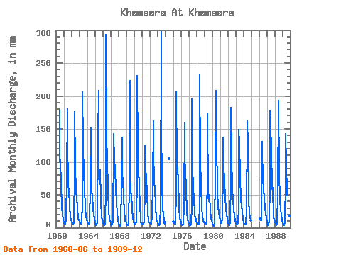
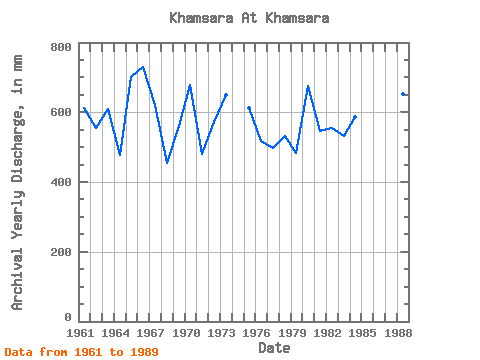
| Year | Jan | Feb | Mar | Apr | May | Jun | Jul | Aug | Sep | Oct | Nov | Dec | Annual | 1960 | 177.57 | 102.96 | 107.34 | 63.61 | 31.00 | 20.67 | 12.05 | 1961 | 7.61 | 5.49 | 6.13 | 10.39 | 79.96 | 179.69 | 140.20 | 65.17 | 56.72 | 33.95 | 15.64 | 12.87 | 611.89 | 1962 | 9.53 | 6.84 | 6.57 | 6.84 | 91.46 | 175.45 | 100.22 | 54.49 | 47.65 | 29.35 | 14.95 | 12.21 | 554.24 | 1963 | 8.93 | 6.39 | 6.19 | 5.57 | 39.98 | 205.66 | 132.53 | 83.24 | 63.08 | 28.53 | 17.76 | 11.88 | 608.93 | 1964 | 9.53 | 5.34 | 4.78 | 6.47 | 67.36 | 152.66 | 64.08 | 55.31 | 48.40 | 29.90 | 20.62 | 14.29 | 478.10 | 1965 | 7.23 | 3.88 | 4.56 | 8.16 | 141.29 | 207.78 | 98.03 | 72.29 | 87.46 | 44.25 | 15.58 | 13.31 | 701.98 | 1966 | 9.04 | 3.76 | 4.17 | 6.94 | 61.88 | 292.59 | 136.36 | 112.82 | 53.54 | 29.14 | 8.85 | 11.61 | 729.76 | 1967 | 7.07 | 3.64 | 4.85 | 9.12 | 130.34 | 142.06 | 105.70 | 91.46 | 59.37 | 37.51 | 22.74 | 10.35 | 620.95 | 1968 | 5.97 | 3.45 | 3.04 | 4.20 | 68.46 | 137.29 | 64.62 | 77.77 | 43.73 | 27.88 | 10.23 | 10.08 | 455.22 | 1969 | 7.56 | 3.62 | 3.38 | 6.36 | 71.74 | 222.63 | 85.43 | 53.83 | 51.89 | 27.55 | 16.96 | 8.98 | 559.96 | 1970 | 6.52 | 5.49 | 6.30 | 7.74 | 87.62 | 231.11 | 124.32 | 100.77 | 55.13 | 40.69 | 9.49 | 6.41 | 679.77 | 1971 | 6.35 | 5.24 | 6.57 | 7.79 | 64.08 | 125.62 | 92.00 | 79.96 | 52.63 | 24.70 | 9.44 | 8.27 | 480.88 | 1972 | 6.90 | 5.34 | 6.35 | 16.80 | 69.00 | 162.20 | 120.48 | 69.00 | 62.02 | 33.79 | 12.56 | 9.26 | 572.20 | 1973 | 6.68 | 4.83 | 3.94 | 6.73 | 30.01 | 296.83 | 162.65 | 69.55 | 29.21 | 21.08 | 11.45 | 7.17 | 650.16 | 1974 | 107.89 | 1975 | 9.09 | 6.69 | 6.41 | 5.83 | 59.69 | 206.72 | 99.67 | 91.46 | 72.09 | 30.01 | 14.31 | 11.12 | 612.48 | 1976 | 7.07 | 3.90 | 3.43 | 5.13 | 37.62 | 160.08 | 104.05 | 94.20 | 56.72 | 25.79 | 10.76 | 9.69 | 517.10 | 1977 | 5.53 | 3.53 | 4.38 | 6.79 | 34.83 | 195.06 | 90.91 | 65.72 | 41.40 | 25.30 | 9.81 | 13.53 | 496.45 | 1978 | 9.53 | 5.49 | 4.69 | 4.84 | 37.35 | 232.70 | 105.70 | 66.27 | 29.89 | 16.81 | 10.12 | 8.21 | 531.65 | 1979 | 5.75 | 5.24 | 6.46 | 10.07 | 90.91 | 172.80 | 49.89 | 41.79 | 50.04 | 25.68 | 14.52 | 10.13 | 483.19 | 1980 | 5.92 | 3.41 | 2.79 | 4.42 | 84.34 | 207.78 | 105.70 | 135.82 | 54.60 | 32.97 | 23.27 | 17.31 | 675.93 | 1981 | 10.52 | 6.74 | 7.50 | 13.78 | 92.00 | 137.29 | 99.12 | 71.74 | 46.38 | 29.52 | 19.40 | 14.51 | 546.38 | 1982 | 8.05 | 4.17 | 4.44 | 8.59 | 78.86 | 182.34 | 108.98 | 62.98 | 40.23 | 30.01 | 15.90 | 11.77 | 554.81 | 1983 | 7.23 | 5.39 | 6.02 | 7.05 | 31.43 | 148.95 | 132.53 | 79.96 | 43.25 | 34.28 | 24.44 | 14.13 | 532.88 | 1984 | 6.79 | 4.87 | 5.21 | 5.99 | 25.03 | 151.60 | 167.03 | 130.89 | 43.84 | 21.80 | 16.38 | 11.61 | 588.00 | 1986 | 13.07 | 11.77 | 11.55 | 135.27 | 119.26 | 77.22 | 60.24 | 43.36 | 31.76 | 21.41 | 15.66 | 1987 | 8.43 | 3.79 | 3.64 | 10.97 | 65.17 | 177.57 | 157.72 | 125.41 | 58.31 | 62.43 | 15.05 | 13.42 | 698.23 | 1988 | 9.58 | 5.44 | 3.99 | 6.41 | 53.72 | 193.47 | 195.51 | 89.27 | 39.01 | 30.01 | 16.43 | 12.32 | 652.27 | 1989 | 7.28 | 4.37 | 3.77 | 7.58 | 72.84 | 142.59 | 101.86 | 52.90 | 30.27 | 27.49 | 17.81 | 13.64 | 480.62 |
|---|
 Return to R-Arctic Net Home Page