|
|
|||||||||||||||||
| Point ID: 6513 | Downloads | Plots | Site Data | Code: 8334 |
|
|
|||||||||||||||||
| Download | |
|---|---|
| Site Descriptor Information | Site Time Series Data |
| Link to all available data | |
|
|
| View: | Statistics | Time Series |
| Units: | mm |
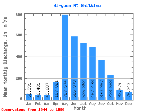
| Statistic | Jan | Feb | Mar | Apr | May | Jun | Jul | Aug | Sep | Oct | Nov | Dec | Annual |
|---|---|---|---|---|---|---|---|---|---|---|---|---|---|
| Mean | 58.39 | 46.48 | 43.69 | 167.02 | 787.57 | 586.98 | 525.36 | 487.48 | 370.96 | 228.55 | 92.88 | 75.34 | 288.68 |
| Standard Deviation | 12.34 | 8.69 | 7.73 | 105.18 | 257.72 | 224.38 | 196.41 | 168.48 | 158.09 | 72.48 | 27.68 | 17.13 | 59.09 |
| Min | 33.80 | 29.30 | 23.10 | 37.30 | 314.00 | 257.00 | 202.00 | 158.00 | 166.00 | 135.00 | 56.50 | 42.60 | 163.22 |
| Max | 93.60 | 66.20 | 60.20 | 422.00 | 1430.00 | 1270.00 | 1060.00 | 933.00 | 1160.00 | 447.00 | 156.00 | 126.00 | 402.93 |
| Coefficient of Variation | 0.21 | 0.19 | 0.18 | 0.63 | 0.33 | 0.38 | 0.37 | 0.35 | 0.43 | 0.32 | 0.30 | 0.23 | 0.20 |
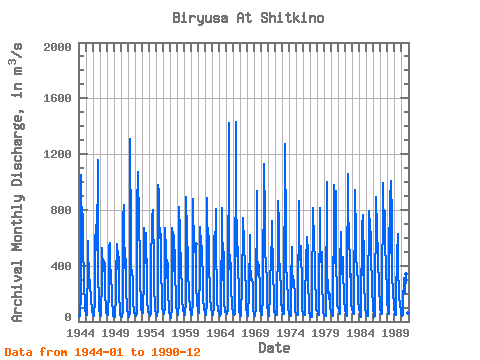
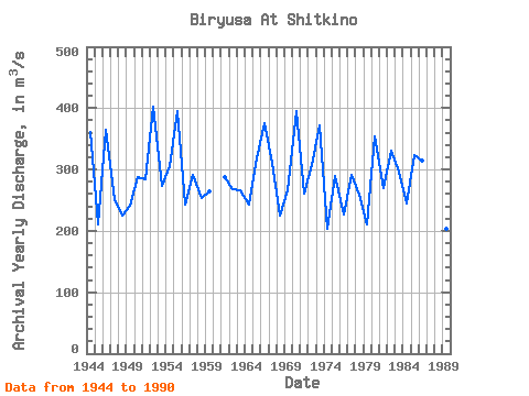
| Year | Jan | Feb | Mar | Apr | May | Jun | Jul | Aug | Sep | Oct | Nov | Dec | Annual | 1944 | 40.50 | 37.80 | 38.60 | 204.00 | 1050.00 | 591.00 | 585.00 | 768.00 | 558.00 | 287.00 | 99.00 | 77.40 | 361.36 | 1945 | 67.60 | 49.90 | 43.90 | 422.00 | 579.00 | 259.00 | 240.00 | 296.00 | 251.00 | 177.00 | 69.50 | 68.20 | 210.26 | 1946 | 55.60 | 46.10 | 41.00 | 151.00 | 559.00 | 691.00 | 598.00 | 513.00 | 1160.00 | 367.00 | 116.00 | 75.90 | 364.47 | 1947 | 61.10 | 46.50 | 40.70 | 311.00 | 529.00 | 362.00 | 448.00 | 426.00 | 417.00 | 230.00 | 66.90 | 63.80 | 250.17 | 1948 | 54.90 | 50.60 | 45.70 | 216.00 | 540.00 | 565.00 | 442.00 | 303.00 | 225.00 | 153.00 | 56.50 | 42.60 | 224.53 | 1949 | 33.80 | 30.30 | 30.40 | 199.00 | 437.00 | 376.00 | 552.00 | 463.00 | 459.00 | 189.00 | 72.20 | 48.70 | 240.87 | 1950 | 38.10 | 33.50 | 31.60 | 74.10 | 739.00 | 832.00 | 387.00 | 530.00 | 376.00 | 245.00 | 85.70 | 76.50 | 287.38 | 1951 | 61.50 | 44.80 | 34.40 | 62.80 | 1310.00 | 577.00 | 378.00 | 370.00 | 292.00 | 151.00 | 58.10 | 64.70 | 283.69 | 1952 | 54.20 | 41.20 | 41.20 | 64.40 | 823.00 | 1070.00 | 1060.00 | 716.00 | 442.00 | 328.00 | 103.00 | 92.10 | 402.93 | 1953 | 68.30 | 58.00 | 57.50 | 324.00 | 670.00 | 418.00 | 487.00 | 634.00 | 261.00 | 164.00 | 68.50 | 72.90 | 273.60 | 1954 | 60.00 | 51.60 | 42.60 | 57.40 | 392.00 | 721.00 | 739.00 | 797.00 | 379.00 | 224.00 | 127.00 | 81.60 | 306.02 | 1955 | 52.20 | 47.10 | 42.80 | 80.90 | 977.00 | 930.00 | 751.00 | 597.00 | 624.00 | 401.00 | 139.00 | 98.80 | 395.07 | 1956 | 66.30 | 58.40 | 52.20 | 98.20 | 668.00 | 495.00 | 386.00 | 311.00 | 416.00 | 213.00 | 84.00 | 65.00 | 242.76 | 1957 | 40.30 | 29.30 | 23.10 | 95.10 | 667.00 | 612.00 | 365.00 | 621.00 | 415.00 | 365.00 | 156.00 | 104.00 | 291.07 | 1958 | 75.00 | 55.60 | 46.50 | 141.00 | 818.00 | 644.00 | 342.00 | 390.00 | 221.00 | 164.00 | 82.30 | 58.10 | 253.12 | 1959 | 48.50 | 44.60 | 44.70 | 146.00 | 892.00 | 617.00 | 454.00 | 314.00 | 261.00 | 198.00 | 79.10 | 75.00 | 264.49 | 1960 | 55.90 | 46.70 | 43.80 | 155.00 | 881.00 | 500.00 | 554.00 | 554.00 | 287.00 | 110.00 | 99.60 | 1961 | 65.60 | 60.20 | 60.20 | 386.00 | 676.00 | 550.00 | 542.00 | 444.00 | 343.00 | 168.00 | 82.80 | 74.20 | 287.67 | 1962 | 59.30 | 49.40 | 46.40 | 140.00 | 887.00 | 455.00 | 613.00 | 367.00 | 261.00 | 185.00 | 81.30 | 73.50 | 268.16 | 1963 | 55.90 | 48.00 | 49.40 | 102.00 | 615.00 | 479.00 | 806.00 | 492.00 | 244.00 | 151.00 | 75.00 | 73.60 | 265.91 | 1964 | 64.60 | 42.80 | 39.20 | 55.80 | 813.00 | 304.00 | 296.00 | 560.00 | 444.00 | 150.00 | 70.30 | 76.80 | 243.04 | 1965 | 69.10 | 59.50 | 56.90 | 91.00 | 1420.00 | 373.00 | 480.00 | 429.00 | 410.00 | 260.00 | 97.80 | 74.20 | 318.38 | 1966 | 57.70 | 47.70 | 44.80 | 53.90 | 1430.00 | 993.00 | 469.00 | 666.00 | 404.00 | 207.00 | 65.50 | 70.70 | 375.77 | 1967 | 50.20 | 42.40 | 39.00 | 279.00 | 686.00 | 742.00 | 553.00 | 574.00 | 363.00 | 229.00 | 85.00 | 80.20 | 310.23 | 1968 | 60.00 | 42.30 | 43.30 | 208.00 | 618.00 | 404.00 | 327.00 | 296.00 | 306.00 | 260.00 | 75.90 | 66.40 | 225.57 | 1969 | 52.40 | 37.30 | 37.00 | 101.00 | 934.00 | 480.00 | 334.00 | 429.00 | 393.00 | 239.00 | 74.00 | 80.20 | 265.91 | 1970 | 60.40 | 49.70 | 45.00 | 185.00 | 1130.00 | 901.00 | 933.00 | 553.00 | 359.00 | 335.00 | 116.00 | 66.80 | 394.49 | 1971 | 59.00 | 43.00 | 35.90 | 200.00 | 536.00 | 377.00 | 487.00 | 718.00 | 317.00 | 205.00 | 69.80 | 73.70 | 260.12 | 1972 | 57.80 | 45.00 | 43.20 | 293.00 | 417.00 | 861.00 | 690.00 | 465.00 | 370.00 | 211.00 | 115.00 | 117.00 | 307.08 | 1973 | 82.60 | 51.70 | 52.70 | 186.00 | 1170.00 | 1270.00 | 622.00 | 423.00 | 279.00 | 175.00 | 80.20 | 67.00 | 371.60 | 1974 | 60.40 | 38.40 | 37.10 | 267.00 | 537.00 | 379.00 | 281.00 | 245.00 | 297.00 | 166.00 | 71.00 | 56.50 | 202.95 | 1975 | 55.50 | 48.90 | 47.20 | 94.70 | 861.00 | 584.00 | 443.00 | 436.00 | 544.00 | 234.00 | 72.00 | 57.70 | 289.83 | 1976 | 53.30 | 44.10 | 44.00 | 69.60 | 514.00 | 378.00 | 606.00 | 499.00 | 257.00 | 138.00 | 59.20 | 57.40 | 226.63 | 1977 | 38.70 | 31.00 | 33.90 | 192.00 | 812.00 | 774.00 | 606.00 | 394.00 | 241.00 | 214.00 | 80.40 | 76.70 | 291.14 | 1978 | 65.00 | 46.70 | 46.20 | 152.00 | 811.00 | 560.00 | 429.00 | 495.00 | 217.00 | 165.00 | 68.90 | 49.60 | 258.78 | 1979 | 42.90 | 38.30 | 41.60 | 68.50 | 1000.00 | 365.00 | 243.00 | 158.00 | 208.00 | 189.00 | 96.70 | 72.50 | 210.29 | 1980 | 55.30 | 45.70 | 42.80 | 80.50 | 853.00 | 975.00 | 416.00 | 933.00 | 390.00 | 249.00 | 109.00 | 102.00 | 354.27 | 1981 | 81.70 | 65.00 | 56.00 | 404.00 | 643.00 | 401.00 | 339.00 | 465.00 | 327.00 | 214.00 | 146.00 | 88.50 | 269.18 | 1982 | 56.90 | 43.90 | 40.80 | 302.00 | 1060.00 | 543.00 | 705.00 | 321.00 | 344.00 | 340.00 | 134.00 | 81.50 | 331.01 | 1983 | 74.80 | 61.00 | 55.40 | 76.50 | 944.00 | 606.00 | 447.00 | 401.00 | 363.00 | 288.00 | 145.00 | 87.30 | 295.75 | 1984 | 59.50 | 41.30 | 32.10 | 37.30 | 723.00 | 332.00 | 762.00 | 393.00 | 208.00 | 191.00 | 105.00 | 53.60 | 244.82 | 1985 | 42.10 | 46.20 | 39.50 | 148.00 | 789.00 | 603.00 | 733.00 | 552.00 | 492.00 | 236.00 | 114.00 | 86.50 | 323.44 | 1986 | 46.70 | 35.10 | 39.00 | 73.30 | 890.00 | 650.00 | 575.00 | 557.00 | 457.00 | 242.00 | 112.00 | 88.50 | 313.80 | 1987 | 67.60 | 57.80 | 52.90 | 107.00 | 996.00 | 613.00 | 626.00 | 789.00 | 496.00 | 447.00 | 154.00 | 126.00 | 377.69 | 1988 | 93.60 | 66.20 | 53.60 | 404.00 | 935.00 | 491.00 | 1010.00 | 742.00 | 343.00 | 201.00 | 115.00 | 79.00 | 377.78 | 1989 | 75.80 | 44.80 | 49.90 | 165.00 | 471.00 | 628.00 | 349.00 | 237.00 | 166.00 | 135.00 | 59.10 | 52.60 | 202.77 | 1990 | 46.20 | 39.20 | 47.60 | 126.00 | 314.00 | 257.00 | 202.00 | 342.00 | 281.00 | 175.00 | 62.60 | 66.00 | 163.22 |
|---|
 Return to R-Arctic Net Home Page