|
|
|||||||||||||||||
| Point ID: 6513 | Downloads | Plots | Site Data | Code: 8334 |
|
|
|||||||||||||||||
| Download | |
|---|---|
| Site Descriptor Information | Site Time Series Data |
| Link to all available data | |
| View: | Time Series | All |
| Units: | mm |
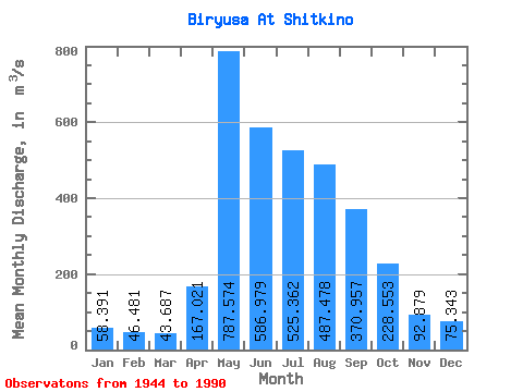
| Statistic | Jan | Feb | Mar | Apr | May | Jun | Jul | Aug | Sep | Oct | Nov | Dec | Annual |
|---|---|---|---|---|---|---|---|---|---|---|---|---|---|
| Mean | 58.39 | 46.48 | 43.69 | 167.02 | 787.57 | 586.98 | 525.36 | 487.48 | 370.96 | 228.55 | 92.88 | 75.34 | 288.68 |
| Standard Deviation | 12.34 | 8.69 | 7.73 | 105.18 | 257.72 | 224.38 | 196.41 | 168.48 | 158.09 | 72.48 | 27.68 | 17.13 | 59.09 |
| Min | 33.80 | 29.30 | 23.10 | 37.30 | 314.00 | 257.00 | 202.00 | 158.00 | 166.00 | 135.00 | 56.50 | 42.60 | 163.22 |
| Max | 93.60 | 66.20 | 60.20 | 422.00 | 1430.00 | 1270.00 | 1060.00 | 933.00 | 1160.00 | 447.00 | 156.00 | 126.00 | 402.93 |
| Coefficient of Variation | 0.21 | 0.19 | 0.18 | 0.63 | 0.33 | 0.38 | 0.37 | 0.35 | 0.43 | 0.32 | 0.30 | 0.23 | 0.20 |
 Return to R-Arctic Net Home Page