|
|
|||||||||||||||||
| Point ID: 6503 | Downloads | Plots | Site Data | Code: 8307 |
|
|
|||||||||||||||||
| Download | |
|---|---|
| Site Descriptor Information | Site Time Series Data |
| Link to all available data | |
|
|
| View: | Statistics | Time Series |
| Units: | mm |
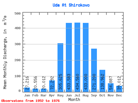
| Statistic | Jan | Feb | Mar | Apr | May | Jun | Jul | Aug | Sep | Oct | Nov | Dec | Annual |
|---|---|---|---|---|---|---|---|---|---|---|---|---|---|
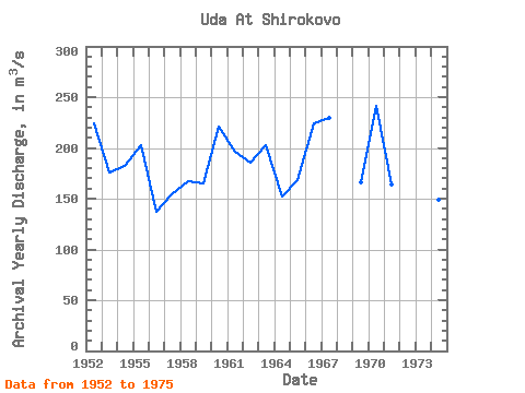
| Mean | 27.22 | 20.56 | 20.01 | 72.29 | 305.62 | 433.58 | 434.56 | 433.00 | 271.20 | 138.96 | 54.89 | 39.01 | 188.19 |
| Standard Deviation | 5.68 | 4.73 | 5.15 | 39.80 | 89.70 | 124.57 | 144.94 | 125.21 | 63.54 | 23.07 | 10.24 | 8.87 | 30.80 |
| Min | 17.50 | 11.60 | 10.50 | 29.10 | 192.00 | 271.00 | 234.00 | 280.00 | 173.00 | 99.10 | 39.30 | 26.50 | 136.91 |
| Max | 39.70 | 29.40 | 34.30 | 174.00 | 515.00 | 780.00 | 666.00 | 800.00 | 460.00 | 188.00 | 79.50 | 63.00 | 241.18 |
| Coefficient of Variation | 0.21 | 0.23 | 0.26 | 0.55 | 0.29 | 0.29 | 0.33 | 0.29 | 0.23 | 0.17 | 0.19 | 0.23 | 0.16 |
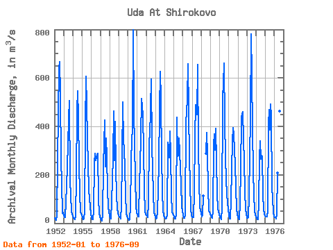
| Year | Jan | Feb | Mar | Apr | May | Jun | Jul | Aug | Sep | Oct | Nov | Dec | Annual | 1952 | 22.90 | 15.50 | 11.90 | 29.10 | 260.00 | 637.00 | 666.00 | 530.00 | 263.00 | 164.00 | 41.50 | 43.70 | 223.72 | 1953 | 30.40 | 24.40 | 24.50 | 151.00 | 237.00 | 324.00 | 432.00 | 506.00 | 173.00 | 116.00 | 47.60 | 38.70 | 175.38 | 1954 | 26.60 | 19.20 | 14.70 | 30.00 | 192.00 | 470.00 | 546.00 | 437.00 | 246.00 | 121.00 | 46.30 | 32.60 | 181.78 | 1955 | 20.50 | 17.20 | 19.80 | 48.80 | 399.00 | 607.00 | 486.00 | 355.00 | 241.00 | 138.00 | 66.20 | 40.10 | 203.22 | 1956 | 23.00 | 16.70 | 16.50 | 50.80 | 247.00 | 288.00 | 260.00 | 285.00 | 289.00 | 99.10 | 41.30 | 26.50 | 136.91 | 1957 | 17.50 | 11.60 | 10.50 | 33.00 | 240.00 | 427.00 | 234.00 | 351.00 | 274.00 | 139.00 | 63.50 | 48.10 | 154.10 | 1958 | 28.90 | 17.50 | 17.40 | 87.80 | 274.00 | 462.00 | 260.00 | 419.00 | 226.00 | 115.00 | 58.10 | 41.80 | 167.29 | 1959 | 31.40 | 23.10 | 19.80 | 73.70 | 271.00 | 501.00 | 339.00 | 305.00 | 225.00 | 123.00 | 39.30 | 27.40 | 164.89 | 1960 | 19.00 | 12.80 | 15.90 | 68.30 | 244.00 | 353.00 | 381.00 | 800.00 | 460.00 | 188.00 | 70.80 | 40.80 | 221.13 | 1961 | 39.00 | 28.40 | 27.20 | 174.00 | 240.00 | 356.00 | 516.00 | 448.00 | 298.00 | 142.00 | 48.70 | 36.90 | 196.18 | 1962 | 32.60 | 29.40 | 24.40 | 81.90 | 347.00 | 356.00 | 595.00 | 323.00 | 221.00 | 129.00 | 45.70 | 35.30 | 185.03 | 1963 | 24.00 | 17.50 | 20.50 | 43.60 | 240.00 | 469.00 | 627.00 | 511.00 | 274.00 | 130.00 | 49.30 | 32.20 | 203.18 | 1964 | 24.60 | 18.80 | 21.20 | 35.20 | 333.00 | 271.00 | 270.00 | 380.00 | 283.00 | 116.00 | 46.50 | 32.10 | 152.62 | 1965 | 26.00 | 18.20 | 17.70 | 35.30 | 438.00 | 278.00 | 280.00 | 350.00 | 295.00 | 162.00 | 66.00 | 51.30 | 168.12 | 1966 | 33.10 | 22.90 | 20.40 | 32.50 | 422.00 | 455.00 | 518.00 | 657.00 | 271.00 | 161.00 | 61.20 | 30.90 | 223.75 | 1967 | 25.30 | 23.20 | 23.10 | 131.00 | 357.00 | 489.00 | 449.00 | 656.00 | 309.00 | 177.00 | 62.00 | 55.10 | 229.72 | 1968 | 39.70 | 27.90 | 34.30 | 112.00 | 287.00 | 374.00 | 283.00 | 149.00 | 51.20 | 46.90 | 1969 | 35.40 | 23.00 | 22.00 | 52.50 | 323.00 | 369.00 | 303.00 | 390.00 | 256.00 | 123.00 | 61.20 | 37.00 | 166.26 | 1970 | 25.30 | 21.20 | 16.70 | 63.40 | 515.00 | 579.00 | 661.00 | 416.00 | 278.00 | 176.00 | 79.50 | 63.00 | 241.18 | 1971 | 30.20 | 19.50 | 18.80 | 95.10 | 219.00 | 339.00 | 394.00 | 366.00 | 242.00 | 147.00 | 57.50 | 36.90 | 163.75 | 1972 | 24.30 | 17.30 | 16.30 | 87.80 | 215.00 | 440.00 | 461.00 | 345.00 | 254.00 | 132.00 | 56.60 | 37.80 | 173.93 | 1973 | 21.90 | 21.10 | 24.30 | 113.00 | 438.00 | 780.00 | 608.00 | 388.00 | 214.00 | 120.00 | 50.00 | 37.20 | 234.62 | 1974 | 26.50 | 16.70 | 16.30 | 88.10 | 269.00 | 340.00 | 266.00 | 280.00 | 273.00 | 118.00 | 60.00 | 35.50 | 149.09 | 1975 | 27.00 | 27.30 | 26.50 | 50.90 | 406.00 | 468.00 | 387.00 | 491.00 | 441.00 | 150.00 | 47.30 | 28.50 | 212.54 | 1976 | 25.30 | 23.50 | 19.60 | 38.50 | 209.00 | 348.00 | 638.00 | 462.00 | 191.00 |
|---|
 Return to R-Arctic Net Home Page