|
|
|||||||||||||||||
| Point ID: 6503 | Downloads | Plots | Site Data | Code: 8307 |
|
|
|||||||||||||||||
| Download | |
|---|---|
| Site Descriptor Information | Site Time Series Data |
| Link to all available data | |
| View: | Time Series | All |
| Units: | mm |
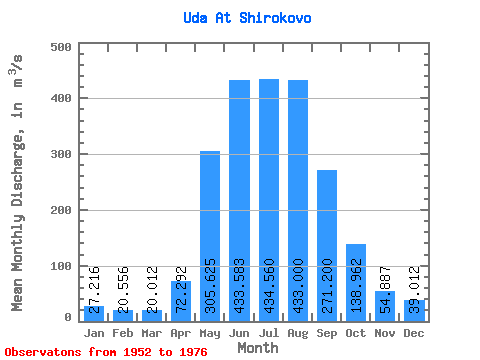
| Statistic | Jan | Feb | Mar | Apr | May | Jun | Jul | Aug | Sep | Oct | Nov | Dec | Annual |
|---|---|---|---|---|---|---|---|---|---|---|---|---|---|
| Mean | 27.22 | 20.56 | 20.01 | 72.29 | 305.62 | 433.58 | 434.56 | 433.00 | 271.20 | 138.96 | 54.89 | 39.01 | 188.19 |
| Standard Deviation | 5.68 | 4.73 | 5.15 | 39.80 | 89.70 | 124.57 | 144.94 | 125.21 | 63.54 | 23.07 | 10.24 | 8.87 | 30.80 |
| Min | 17.50 | 11.60 | 10.50 | 29.10 | 192.00 | 271.00 | 234.00 | 280.00 | 173.00 | 99.10 | 39.30 | 26.50 | 136.91 |
| Max | 39.70 | 29.40 | 34.30 | 174.00 | 515.00 | 780.00 | 666.00 | 800.00 | 460.00 | 188.00 | 79.50 | 63.00 | 241.18 |
| Coefficient of Variation | 0.21 | 0.23 | 0.26 | 0.55 | 0.29 | 0.29 | 0.33 | 0.29 | 0.23 | 0.17 | 0.19 | 0.23 | 0.16 |
 Return to R-Arctic Net Home Page