|
|
|||||||||||||||||
| Point ID: 6501 | Downloads | Plots | Site Data | Code: 8299 |
|
|
|||||||||||||||||
| Download | |
|---|---|
| Site Descriptor Information | Site Time Series Data |
| Link to all available data | |
|
|
| View: | Statistics | Time Series |
| Units: | mm |
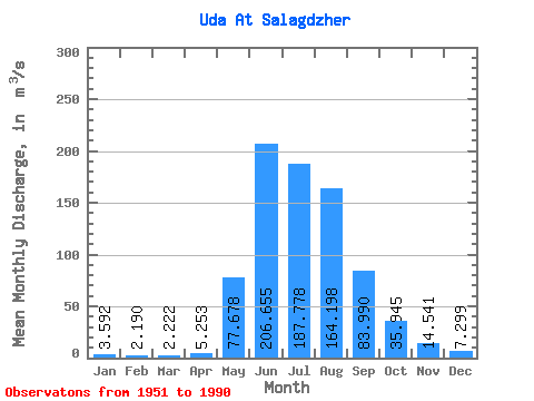
| Statistic | Jan | Feb | Mar | Apr | May | Jun | Jul | Aug | Sep | Oct | Nov | Dec | Annual |
|---|---|---|---|---|---|---|---|---|---|---|---|---|---|
| Mean | 3.59 | 2.19 | 2.22 | 5.25 | 77.68 | 206.66 | 187.78 | 164.20 | 83.99 | 35.95 | 14.54 | 7.30 | 65.94 |
| Standard Deviation | 0.98 | 0.64 | 0.71 | 3.03 | 37.04 | 58.29 | 62.15 | 50.77 | 23.16 | 7.14 | 3.00 | 1.43 | 10.65 |
| Min | 1.74 | 1.07 | 1.15 | 1.65 | 10.90 | 73.80 | 92.10 | 82.00 | 47.30 | 26.10 | 7.97 | 4.59 | 46.64 |
| Max | 6.09 | 3.47 | 4.04 | 12.80 | 204.00 | 364.00 | 349.00 | 297.00 | 149.00 | 66.70 | 20.80 | 10.80 | 84.95 |
| Coefficient of Variation | 0.27 | 0.29 | 0.32 | 0.58 | 0.48 | 0.28 | 0.33 | 0.31 | 0.28 | 0.20 | 0.21 | 0.20 | 0.16 |
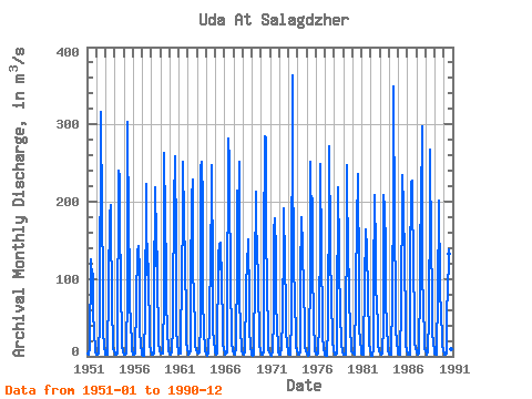
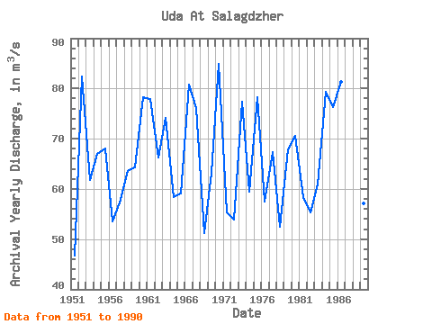
| Year | Jan | Feb | Mar | Apr | May | Jun | Jul | Aug | Sep | Oct | Nov | Dec | Annual | 1951 | 3.00 | 1.80 | 3.03 | 9.70 | 126.00 | 96.40 | 112.00 | 102.00 | 62.80 | 26.10 | 11.70 | 5.20 | 46.64 | 1952 | 2.69 | 1.74 | 1.46 | 2.91 | 45.20 | 316.00 | 282.00 | 215.00 | 70.00 | 34.70 | 10.90 | 6.33 | 82.41 | 1953 | 2.64 | 1.55 | 2.03 | 5.34 | 86.10 | 188.00 | 164.00 | 196.00 | 49.10 | 29.00 | 10.10 | 6.83 | 61.72 | 1954 | 3.57 | 2.16 | 1.97 | 3.04 | 10.90 | 240.00 | 233.00 | 178.00 | 84.80 | 28.60 | 11.90 | 5.76 | 66.97 | 1955 | 2.56 | 2.47 | 2.38 | 3.73 | 84.30 | 303.00 | 162.00 | 117.00 | 72.40 | 40.10 | 18.70 | 7.43 | 68.01 | 1956 | 2.54 | 1.90 | 1.46 | 3.69 | 70.90 | 138.00 | 120.00 | 142.00 | 110.00 | 33.10 | 14.30 | 5.12 | 53.58 | 1957 | 1.97 | 1.07 | 1.35 | 4.23 | 52.40 | 223.00 | 105.00 | 146.00 | 95.40 | 35.40 | 14.80 | 7.65 | 57.36 | 1958 | 4.17 | 2.66 | 2.11 | 4.09 | 79.10 | 218.00 | 117.00 | 184.00 | 86.20 | 38.00 | 18.50 | 8.21 | 63.50 | 1959 | 4.19 | 3.06 | 2.98 | 4.05 | 78.40 | 263.00 | 179.00 | 113.00 | 75.00 | 31.20 | 10.70 | 6.91 | 64.29 | 1960 | 3.59 | 2.14 | 2.47 | 4.44 | 38.80 | 226.00 | 196.00 | 259.00 | 149.00 | 34.90 | 14.80 | 7.96 | 78.26 | 1961 | 3.97 | 3.01 | 3.10 | 12.80 | 107.00 | 178.00 | 252.00 | 176.00 | 123.00 | 49.10 | 18.00 | 8.78 | 77.90 | 1962 | 4.55 | 2.77 | 3.43 | 5.84 | 96.10 | 205.00 | 229.00 | 111.00 | 78.70 | 35.30 | 14.70 | 7.99 | 66.20 | 1963 | 5.58 | 3.47 | 4.04 | 5.31 | 42.30 | 245.00 | 251.00 | 201.00 | 79.90 | 29.60 | 14.20 | 7.77 | 74.10 | 1964 | 3.98 | 1.85 | 1.42 | 3.06 | 41.50 | 140.00 | 92.10 | 248.00 | 106.00 | 35.40 | 17.40 | 8.79 | 58.29 | 1965 | 4.93 | 2.48 | 3.15 | 4.76 | 129.00 | 146.00 | 113.00 | 147.00 | 95.10 | 39.70 | 14.90 | 8.77 | 59.07 | 1966 | 4.73 | 2.85 | 3.37 | 5.12 | 38.90 | 282.00 | 250.00 | 236.00 | 80.90 | 41.70 | 16.20 | 7.25 | 80.75 | 1967 | 2.95 | 1.88 | 2.53 | 12.60 | 122.00 | 215.00 | 177.00 | 251.00 | 76.20 | 34.40 | 11.40 | 6.60 | 76.13 | 1968 | 3.75 | 1.74 | 2.68 | 4.83 | 83.90 | 127.00 | 115.00 | 151.00 | 70.90 | 34.90 | 12.10 | 5.59 | 51.12 | 1969 | 2.41 | 1.14 | 1.54 | 4.58 | 107.00 | 213.00 | 134.00 | 156.00 | 81.70 | 33.00 | 15.30 | 7.98 | 63.14 | 1970 | 3.45 | 2.37 | 1.73 | 4.94 | 138.00 | 284.00 | 282.00 | 172.00 | 80.50 | 36.60 | 7.97 | 5.82 | 84.95 | 1971 | 2.40 | 1.42 | 1.15 | 5.97 | 50.30 | 162.00 | 179.00 | 134.00 | 69.80 | 37.40 | 13.70 | 5.78 | 55.24 | 1972 | 2.69 | 1.75 | 1.93 | 11.60 | 48.40 | 151.00 | 191.00 | 120.00 | 64.60 | 33.10 | 13.30 | 7.41 | 53.90 | 1973 | 3.34 | 2.17 | 2.73 | 4.46 | 49.20 | 364.00 | 254.00 | 129.00 | 62.30 | 36.80 | 12.10 | 7.24 | 77.28 | 1974 | 3.63 | 1.64 | 1.59 | 6.20 | 103.00 | 180.00 | 141.00 | 132.00 | 91.20 | 35.70 | 11.80 | 5.82 | 59.47 | 1975 | 3.58 | 1.82 | 1.39 | 2.28 | 121.00 | 251.00 | 164.00 | 205.00 | 127.00 | 36.40 | 18.60 | 6.02 | 78.17 | 1976 | 3.45 | 2.28 | 1.79 | 3.00 | 43.60 | 163.00 | 249.00 | 133.00 | 48.00 | 27.50 | 9.95 | 4.59 | 57.43 | 1977 | 1.77 | 1.10 | 1.16 | 1.65 | 37.70 | 225.00 | 272.00 | 144.00 | 65.20 | 31.90 | 18.90 | 8.49 | 67.41 | 1978 | 4.27 | 2.59 | 2.02 | 3.67 | 40.90 | 219.00 | 135.00 | 127.00 | 47.30 | 27.40 | 15.50 | 5.77 | 52.53 | 1979 | 1.74 | 1.48 | 1.96 | 2.61 | 204.00 | 248.00 | 109.00 | 113.00 | 76.90 | 33.00 | 15.50 | 6.97 | 67.85 | 1980 | 4.57 | 2.89 | 3.08 | 2.75 | 76.70 | 190.00 | 167.00 | 236.00 | 94.70 | 41.40 | 16.60 | 10.80 | 70.54 | 1981 | 3.97 | 2.07 | 2.43 | 12.70 | 90.20 | 164.00 | 148.00 | 151.00 | 68.70 | 34.10 | 17.70 | 5.74 | 58.38 | 1982 | 2.97 | 1.29 | 1.20 | 10.40 | 90.90 | 208.00 | 136.00 | 82.00 | 73.80 | 33.70 | 16.40 | 6.99 | 55.30 | 1983 | 4.44 | 3.20 | 2.53 | 3.14 | 42.30 | 209.00 | 193.00 | 139.00 | 73.30 | 36.90 | 15.60 | 7.64 | 60.84 | 1984 | 3.60 | 2.14 | 2.18 | 2.39 | 74.00 | 213.00 | 349.00 | 167.00 | 77.80 | 36.20 | 16.10 | 8.28 | 79.31 | 1985 | 3.98 | 2.69 | 1.59 | 3.88 | 60.80 | 226.00 | 234.00 | 193.00 | 125.00 | 43.00 | 15.10 | 7.47 | 76.38 | 1986 | 4.19 | 2.17 | 1.95 | 2.65 | 109.00 | 225.00 | 227.00 | 211.00 | 116.00 | 49.90 | 16.60 | 10.20 | 81.31 | 1987 | 4.52 | 3.23 | 2.23 | 3.87 | 92.50 | 150.00 | 191.00 | 297.00 | 104.00 | 66.70 | 20.80 | 9.69 | 78.80 | 1988 | 6.09 | 3.03 | 2.75 | 7.01 | 49.70 | 199.00 | 268.00 | 132.00 | 92.90 | 33.70 | 14.90 | 8.62 | 68.14 | 1989 | 3.87 | 2.68 | 2.47 | 7.38 | 76.20 | 199.00 | 201.00 | 89.90 | 49.50 | 30.70 | 15.00 | 6.74 | 57.04 | 1990 | 3.40 | 1.84 | 2.50 | 3.46 | 68.90 | 73.80 | 138.00 | 132.00 | 104.00 | 31.50 | 8.91 | 8.95 | 48.10 |
|---|
 Return to R-Arctic Net Home Page