|
|
|||||||||||||||||
| Point ID: 6483 | Downloads | Plots | Site Data | Code: 8230 |
|
|
|||||||||||||||||
| Download | |
|---|---|
| Site Descriptor Information | Site Time Series Data |
| Link to all available data | |
|
|
| View: | Statistics | Time Series |
| Units: | mm |
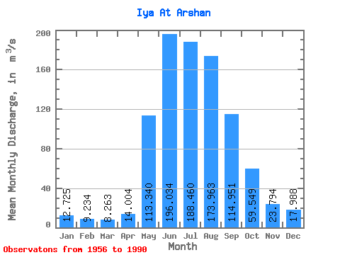
| Statistic | Jan | Feb | Mar | Apr | May | Jun | Jul | Aug | Sep | Oct | Nov | Dec | Annual |
|---|---|---|---|---|---|---|---|---|---|---|---|---|---|
| Mean | 12.72 | 9.23 | 8.26 | 14.00 | 113.34 | 196.03 | 188.46 | 173.96 | 114.95 | 59.55 | 23.79 | 17.99 | 77.94 |
| Standard Deviation | 2.94 | 2.05 | 1.63 | 5.48 | 41.68 | 74.03 | 82.19 | 67.09 | 39.95 | 20.75 | 6.52 | 4.58 | 21.17 |
| Min | 7.36 | 4.05 | 5.33 | 5.20 | 26.80 | 60.60 | 55.90 | 46.60 | 25.90 | 20.40 | 10.50 | 9.14 | 33.72 |
| Max | 21.10 | 13.50 | 11.20 | 23.70 | 197.00 | 400.00 | 449.00 | 367.00 | 187.00 | 104.00 | 38.40 | 28.40 | 113.55 |
| Coefficient of Variation | 0.23 | 0.22 | 0.20 | 0.39 | 0.37 | 0.38 | 0.44 | 0.39 | 0.35 | 0.35 | 0.27 | 0.25 | 0.27 |
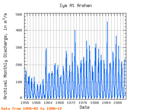
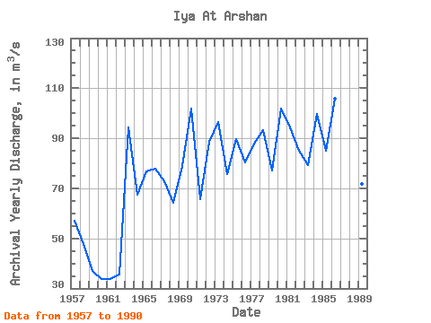
| Year | Jan | Feb | Mar | Apr | May | Jun | Jul | Aug | Sep | Oct | Nov | Dec | Annual | 1956 | 8.37 | 13.40 | 119.00 | 138.00 | 141.00 | 169.00 | 148.00 | 48.00 | 13.30 | 9.44 | 1957 | 8.90 | 10.80 | 7.46 | 10.70 | 76.10 | 127.00 | 88.00 | 133.00 | 131.00 | 49.90 | 29.20 | 12.10 | 57.01 | 1958 | 12.70 | 8.01 | 7.40 | 8.29 | 87.80 | 116.00 | 63.90 | 122.00 | 62.10 | 38.20 | 24.20 | 20.70 | 47.61 | 1959 | 13.90 | 8.54 | 10.40 | 14.60 | 45.60 | 128.00 | 72.20 | 60.70 | 38.20 | 25.30 | 15.50 | 10.30 | 36.94 | 1960 | 10.90 | 9.08 | 6.18 | 6.53 | 26.80 | 85.20 | 55.90 | 84.30 | 64.10 | 24.20 | 18.00 | 13.50 | 33.72 | 1961 | 7.53 | 8.06 | 11.20 | 22.00 | 52.00 | 60.60 | 89.10 | 71.10 | 37.80 | 22.90 | 10.80 | 12.50 | 33.80 | 1962 | 7.74 | 5.24 | 7.82 | 10.10 | 55.20 | 98.40 | 116.00 | 46.60 | 25.90 | 20.40 | 10.50 | 22.50 | 35.53 | 1963 | 18.80 | 11.10 | 9.48 | 8.91 | 108.00 | 270.00 | 293.00 | 168.00 | 124.00 | 68.00 | 22.70 | 28.40 | 94.20 | 1964 | 21.10 | 11.30 | 5.33 | 5.20 | 98.00 | 136.00 | 152.00 | 150.00 | 117.00 | 74.70 | 21.00 | 18.40 | 67.50 | 1965 | 13.10 | 8.56 | 7.17 | 7.02 | 147.00 | 147.00 | 139.00 | 161.00 | 137.00 | 97.90 | 36.10 | 18.50 | 76.61 | 1966 | 12.70 | 10.40 | 8.46 | 10.10 | 92.30 | 194.00 | 178.00 | 207.00 | 102.00 | 74.60 | 28.80 | 17.50 | 77.99 | 1967 | 10.10 | 7.53 | 6.74 | 21.30 | 122.00 | 167.00 | 160.00 | 195.00 | 92.20 | 59.50 | 20.10 | 13.90 | 72.95 | 1968 | 13.10 | 12.40 | 10.40 | 21.10 | 123.00 | 119.00 | 119.00 | 137.00 | 113.00 | 62.90 | 22.90 | 15.30 | 64.09 | 1969 | 12.70 | 10.60 | 7.42 | 11.90 | 168.00 | 191.00 | 159.00 | 160.00 | 122.00 | 55.00 | 28.40 | 20.60 | 78.89 | 1970 | 13.70 | 10.70 | 6.96 | 11.00 | 197.00 | 278.00 | 245.00 | 174.00 | 146.00 | 85.60 | 28.20 | 24.20 | 101.70 | 1971 | 12.60 | 8.67 | 6.00 | 17.70 | 73.10 | 122.00 | 142.00 | 195.00 | 115.00 | 58.20 | 22.80 | 14.10 | 65.60 | 1972 | 14.60 | 7.43 | 5.47 | 22.20 | 89.20 | 228.00 | 268.00 | 166.00 | 136.00 | 74.50 | 35.60 | 17.40 | 88.70 | 1973 | 11.20 | 10.60 | 9.59 | 11.70 | 96.80 | 400.00 | 257.00 | 182.00 | 98.40 | 45.40 | 18.40 | 16.80 | 96.49 | 1974 | 13.80 | 9.45 | 7.96 | 23.70 | 148.00 | 195.00 | 167.00 | 126.00 | 113.00 | 58.80 | 24.10 | 20.50 | 75.61 | 1975 | 13.80 | 9.19 | 6.86 | 9.85 | 153.00 | 210.00 | 156.00 | 225.00 | 181.00 | 68.60 | 21.30 | 22.50 | 89.76 | 1976 | 16.70 | 13.50 | 11.20 | 12.90 | 91.80 | 228.00 | 245.00 | 172.00 | 94.40 | 46.90 | 19.40 | 13.70 | 80.46 | 1977 | 7.36 | 4.05 | 5.52 | 11.00 | 106.00 | 338.00 | 246.00 | 156.00 | 88.50 | 48.90 | 22.90 | 19.60 | 87.82 | 1978 | 13.10 | 7.97 | 7.51 | 19.00 | 115.00 | 311.00 | 246.00 | 215.00 | 105.00 | 42.00 | 20.80 | 18.20 | 93.38 | 1979 | 8.51 | 6.00 | 7.76 | 9.08 | 192.00 | 167.00 | 114.00 | 159.00 | 151.00 | 69.70 | 23.40 | 18.30 | 77.15 | 1980 | 12.30 | 10.40 | 9.98 | 9.35 | 143.00 | 296.00 | 197.00 | 321.00 | 125.00 | 70.70 | 17.10 | 9.14 | 101.75 | 1981 | 11.60 | 10.70 | 9.97 | 22.60 | 144.00 | 233.00 | 155.00 | 292.00 | 136.00 | 66.30 | 25.30 | 27.00 | 94.46 | 1982 | 13.20 | 5.50 | 8.39 | 23.30 | 191.00 | 258.00 | 194.00 | 114.00 | 107.00 | 59.50 | 25.60 | 18.80 | 84.86 | 1983 | 13.70 | 9.97 | 8.86 | 10.10 | 80.40 | 227.00 | 185.00 | 164.00 | 139.00 | 67.70 | 26.90 | 18.30 | 79.24 | 1984 | 12.80 | 9.99 | 7.82 | 10.80 | 140.00 | 201.00 | 449.00 | 210.00 | 74.50 | 37.60 | 24.60 | 16.60 | 99.56 | 1985 | 10.60 | 9.55 | 8.90 | 13.00 | 97.70 | 205.00 | 200.00 | 210.00 | 160.00 | 60.50 | 25.60 | 18.10 | 84.91 | 1986 | 16.30 | 8.29 | 8.23 | 13.20 | 150.00 | 203.00 | 275.00 | 253.00 | 187.00 | 93.70 | 38.40 | 22.90 | 105.75 | 1987 | 13.70 | 12.00 | 11.00 | 14.80 | 144.00 | 208.00 | 272.00 | 367.00 | 163.00 | 104.00 | 29.40 | 23.70 | 113.55 | 1988 | 15.30 | 9.41 | 8.82 | 23.20 | 88.70 | 220.00 | 310.00 | 152.00 | 128.00 | 67.50 | 28.70 | 20.20 | 89.32 | 1989 | 12.80 | 9.46 | 9.68 | 16.10 | 82.40 | 198.00 | 218.00 | 145.00 | 81.20 | 49.90 | 20.70 | 18.10 | 71.78 | 1990 | 11.70 | 9.49 | 8.89 | 14.40 | 123.00 | 158.00 | 229.00 | 226.00 | 180.00 | 86.70 | 32.10 | 17.80 | 91.42 |
|---|
 Return to R-Arctic Net Home Page