|
|
|||||||||||||||||
| Point ID: 6483 | Downloads | Plots | Site Data | Code: 8230 |
|
|
|||||||||||||||||
| Download | |
|---|---|
| Site Descriptor Information | Site Time Series Data |
| Link to all available data | |
| View: | Time Series | All |
| Units: | mm |
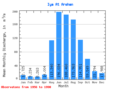
| Statistic | Jan | Feb | Mar | Apr | May | Jun | Jul | Aug | Sep | Oct | Nov | Dec | Annual |
|---|---|---|---|---|---|---|---|---|---|---|---|---|---|
| Mean | 12.72 | 9.23 | 8.26 | 14.00 | 113.34 | 196.03 | 188.46 | 173.96 | 114.95 | 59.55 | 23.79 | 17.99 | 77.94 |
| Standard Deviation | 2.94 | 2.05 | 1.63 | 5.48 | 41.68 | 74.03 | 82.19 | 67.09 | 39.95 | 20.75 | 6.52 | 4.58 | 21.17 |
| Min | 7.36 | 4.05 | 5.33 | 5.20 | 26.80 | 60.60 | 55.90 | 46.60 | 25.90 | 20.40 | 10.50 | 9.14 | 33.72 |
| Max | 21.10 | 13.50 | 11.20 | 23.70 | 197.00 | 400.00 | 449.00 | 367.00 | 187.00 | 104.00 | 38.40 | 28.40 | 113.55 |
| Coefficient of Variation | 0.23 | 0.22 | 0.20 | 0.39 | 0.37 | 0.38 | 0.44 | 0.39 | 0.35 | 0.35 | 0.27 | 0.25 | 0.27 |
 Return to R-Arctic Net Home Page