|
|
|||||||||||||||||
| Point ID: 6478 | Downloads | Plots | Site Data | Code: 8204 |
|
|
|||||||||||||||||
| Download | |
|---|---|
| Site Descriptor Information | Site Time Series Data |
| Link to all available data | |
|
|
| View: | Statistics | Time Series |
| Units: | mm |
| Statistic | Jan | Feb | Mar | Apr | May | Jun | Jul | Aug | Sep | Oct | Nov | Dec | Annual |
|---|---|---|---|---|---|---|---|---|---|---|---|---|---|
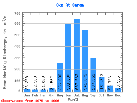
| Mean | 26.26 | 22.30 | 21.07 | 34.56 | 256.69 | 593.00 | 637.56 | 541.88 | 297.56 | 131.31 | 56.76 | 33.56 | 221.04 |
| Standard Deviation | 9.05 | 4.63 | 3.83 | 12.79 | 98.82 | 118.05 | 197.59 | 167.31 | 88.44 | 33.36 | 12.62 | 10.43 | 37.33 |
| Min | 9.92 | 16.30 | 12.30 | 20.40 | 102.00 | 345.00 | 346.00 | 312.00 | 167.00 | 79.80 | 37.80 | 18.10 | 154.91 |
| Max | 50.10 | 35.10 | 26.50 | 67.20 | 441.00 | 762.00 | 1100.00 | 841.00 | 515.00 | 193.00 | 81.10 | 61.50 | 274.10 |
| Coefficient of Variation | 0.34 | 0.21 | 0.18 | 0.37 | 0.39 | 0.20 | 0.31 | 0.31 | 0.30 | 0.25 | 0.22 | 0.31 | 0.17 |
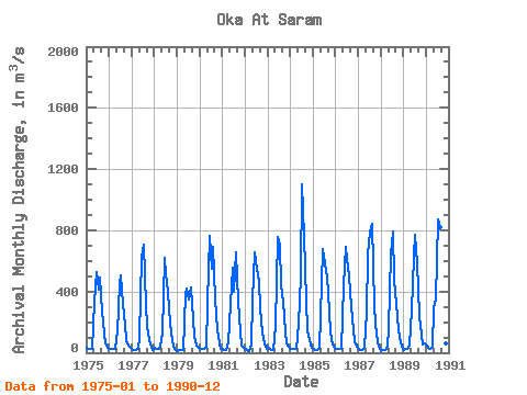
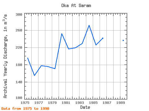
| Year | Jan | Feb | Mar | Apr | May | Jun | Jul | Aug | Sep | Oct | Nov | Dec | Annual | 1975 | 30.80 | 22.90 | 21.70 | 27.30 | 330.00 | 526.00 | 415.00 | 488.00 | 271.00 | 126.00 | 59.80 | 31.60 | 195.84 | 1976 | 27.10 | 24.60 | 23.30 | 28.60 | 142.00 | 450.00 | 508.00 | 318.00 | 182.00 | 79.80 | 43.40 | 32.10 | 154.91 | 1977 | 21.20 | 16.30 | 17.80 | 26.80 | 102.00 | 625.00 | 706.00 | 312.00 | 167.00 | 81.00 | 37.80 | 19.00 | 177.66 | 1978 | 31.60 | 24.60 | 25.80 | 37.90 | 129.00 | 622.00 | 509.00 | 395.00 | 189.00 | 82.20 | 41.90 | 18.10 | 175.51 | 1979 | 9.92 | 17.60 | 19.70 | 20.90 | 382.00 | 422.00 | 346.00 | 426.00 | 221.00 | 105.00 | 43.60 | 30.00 | 170.31 | 1980 | 27.00 | 25.60 | 26.50 | 29.20 | 327.00 | 762.00 | 549.00 | 693.00 | 355.00 | 146.00 | 58.70 | 27.10 | 252.18 | 1981 | 23.30 | 19.00 | 16.10 | 67.20 | 322.00 | 554.00 | 396.00 | 655.00 | 333.00 | 134.00 | 45.60 | 32.20 | 216.45 | 1982 | 25.40 | 18.40 | 12.30 | 54.60 | 341.00 | 653.00 | 551.00 | 473.00 | 289.00 | 134.00 | 57.40 | 26.60 | 219.64 | 1983 | 35.90 | 22.20 | 20.90 | 20.40 | 175.00 | 757.00 | 709.00 | 440.00 | 331.00 | 138.00 | 64.50 | 38.20 | 229.34 | 1984 | 26.20 | 25.30 | 22.50 | 27.60 | 191.00 | 499.00 | 1100.00 | 767.00 | 343.00 | 141.00 | 81.10 | 34.40 | 271.51 | 1985 | 22.70 | 20.70 | 19.20 | 29.80 | 239.00 | 678.00 | 586.00 | 489.00 | 396.00 | 135.00 | 50.40 | 41.20 | 225.58 | 1986 | 28.00 | 24.40 | 21.60 | 26.30 | 441.00 | 690.00 | 610.00 | 495.00 | 303.00 | 148.00 | 72.50 | 37.00 | 241.40 | 1987 | 26.70 | 20.40 | 21.50 | 29.60 | 264.00 | 640.00 | 786.00 | 841.00 | 305.00 | 190.00 | 68.20 | 25.40 | 268.15 | 1988 | 13.10 | 16.70 | 18.00 | 37.20 | 161.00 | 640.00 | 789.00 | 477.00 | 320.00 | 149.00 | 69.80 | 38.90 | 227.47 | 1989 | 21.10 | 23.00 | 24.70 | 48.70 | 274.00 | 625.00 | 770.00 | 581.00 | 241.00 | 119.00 | 50.40 | 61.50 | 236.62 | 1990 | 50.10 | 35.10 | 25.50 | 40.90 | 287.00 | 345.00 | 871.00 | 820.00 | 515.00 | 193.00 | 63.00 | 43.60 | 274.10 |
|---|
 Return to R-Arctic Net Home Page