|
|
|||||||||||||||||
| Point ID: 6470 | Downloads | Plots | Site Data | Code: 8169 |
|
|
|||||||||||||||||
| Download | |
|---|---|
| Site Descriptor Information | Site Time Series Data |
| Link to all available data | |
|
|
| View: | Statistics | Time Series |
| Units: | mm |
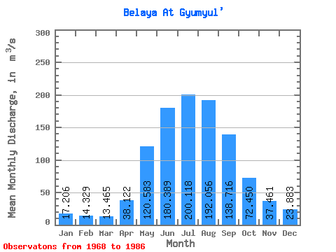
| Statistic | Jan | Feb | Mar | Apr | May | Jun | Jul | Aug | Sep | Oct | Nov | Dec | Annual |
|---|---|---|---|---|---|---|---|---|---|---|---|---|---|
| Mean | 17.21 | 14.33 | 13.46 | 38.12 | 120.58 | 180.39 | 200.12 | 192.06 | 138.72 | 72.45 | 37.46 | 23.88 | 88.96 |
| Standard Deviation | 2.31 | 2.59 | 2.79 | 10.98 | 39.71 | 50.83 | 42.87 | 55.37 | 32.29 | 9.92 | 5.25 | 2.62 | 11.56 |
| Min | 12.80 | 10.20 | 7.41 | 23.60 | 59.30 | 112.00 | 123.00 | 120.00 | 86.50 | 58.40 | 29.20 | 19.80 | 69.78 |
| Max | 21.50 | 20.40 | 20.00 | 62.90 | 219.00 | 294.00 | 282.00 | 302.00 | 226.00 | 95.30 | 48.30 | 28.70 | 108.78 |
| Coefficient of Variation | 0.13 | 0.18 | 0.21 | 0.29 | 0.33 | 0.28 | 0.21 | 0.29 | 0.23 | 0.14 | 0.14 | 0.11 | 0.13 |
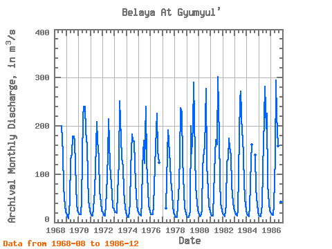
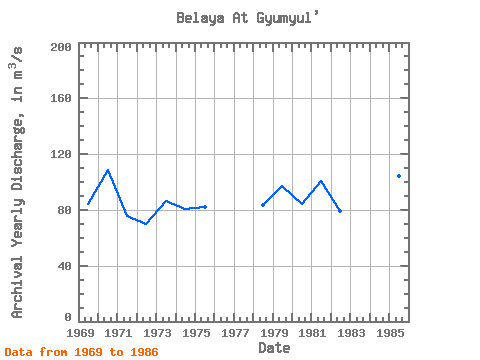
| Year | Jan | Feb | Mar | Apr | May | Jun | Jul | Aug | Sep | Oct | Nov | Dec | Annual | 1968 | 200.00 | 142.00 | 72.70 | 33.50 | 22.60 | 1969 | 14.60 | 10.80 | 7.41 | 43.60 | 130.00 | 142.00 | 178.00 | 178.00 | 167.00 | 73.80 | 39.50 | 23.70 | 84.03 | 1970 | 17.90 | 16.70 | 16.20 | 44.50 | 219.00 | 240.00 | 240.00 | 188.00 | 158.00 | 95.30 | 44.80 | 25.00 | 108.78 | 1971 | 17.60 | 14.00 | 14.20 | 46.70 | 64.80 | 112.00 | 208.00 | 170.00 | 134.00 | 64.30 | 40.30 | 24.20 | 75.84 | 1972 | 20.10 | 15.00 | 14.30 | 37.30 | 59.30 | 139.00 | 214.00 | 120.00 | 98.10 | 61.30 | 30.90 | 28.00 | 69.78 | 1973 | 21.50 | 20.40 | 20.00 | 61.10 | 126.00 | 251.00 | 174.00 | 134.00 | 115.00 | 65.00 | 29.20 | 20.60 | 86.48 | 1974 | 15.00 | 11.30 | 10.90 | 38.20 | 111.00 | 183.00 | 169.00 | 168.00 | 121.00 | 82.80 | 35.80 | 24.00 | 80.83 | 1975 | 17.90 | 15.80 | 13.50 | 41.90 | 116.00 | 170.00 | 123.00 | 240.00 | 126.00 | 67.10 | 34.70 | 22.30 | 82.35 | 1976 | 16.30 | 16.10 | 16.50 | 34.60 | 116.00 | 157.00 | 226.00 | 148.00 | 124.00 | 1977 | 29.50 | 90.10 | 191.00 | 169.00 | 121.00 | 86.50 | 58.40 | 33.90 | 20.00 | 1978 | 15.40 | 11.40 | 10.80 | 34.20 | 81.30 | 138.00 | 237.00 | 229.00 | 130.00 | 61.40 | 29.60 | 19.80 | 83.16 | 1979 | 12.80 | 10.20 | 11.20 | 24.10 | 200.00 | 143.00 | 198.00 | 290.00 | 140.00 | 74.60 | 39.70 | 24.50 | 97.34 | 1980 | 15.80 | 12.90 | 13.10 | 23.60 | 115.00 | 149.00 | 156.00 | 278.00 | 120.00 | 66.30 | 34.20 | 23.10 | 83.92 | 1981 | 16.40 | 13.70 | 14.30 | 62.90 | 141.00 | 171.00 | 161.00 | 302.00 | 177.00 | 85.60 | 39.50 | 24.80 | 100.77 | 1982 | 17.50 | 14.70 | 12.90 | 36.00 | 125.00 | 133.00 | 174.00 | 156.00 | 139.00 | 75.30 | 42.50 | 28.70 | 79.55 | 1983 | 20.50 | 15.80 | 13.50 | 24.60 | 101.00 | 256.00 | 272.00 | 182.00 | 180.00 | 84.90 | 48.30 | 24.40 | 101.92 | 1984 | 17.80 | 13.70 | 12.20 | 32.00 | 129.00 | 162.00 | 140.00 | 69.20 | 36.10 | 21.70 | 1985 | 15.70 | 14.20 | 12.40 | 35.00 | 111.00 | 216.00 | 282.00 | 194.00 | 226.00 | 78.40 | 39.90 | 24.00 | 104.05 | 1986 | 19.70 | 16.90 | 15.50 | 36.40 | 135.00 | 294.00 | 221.00 | 159.00 | 112.00 | 67.70 | 41.90 | 28.50 | 95.63 |
|---|
 Return to R-Arctic Net Home Page