|
|
|||||||||||||||||
| Point ID: 6470 | Downloads | Plots | Site Data | Code: 8169 |
|
|
|||||||||||||||||
| Download | |
|---|---|
| Site Descriptor Information | Site Time Series Data |
| Link to all available data | |
| View: | Time Series | All |
| Units: | mm |
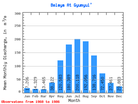
| Statistic | Jan | Feb | Mar | Apr | May | Jun | Jul | Aug | Sep | Oct | Nov | Dec | Annual |
|---|---|---|---|---|---|---|---|---|---|---|---|---|---|
| Mean | 17.21 | 14.33 | 13.46 | 38.12 | 120.58 | 180.39 | 200.12 | 192.06 | 138.72 | 72.45 | 37.46 | 23.88 | 88.96 |
| Standard Deviation | 2.31 | 2.59 | 2.79 | 10.98 | 39.71 | 50.83 | 42.87 | 55.37 | 32.29 | 9.92 | 5.25 | 2.62 | 11.56 |
| Min | 12.80 | 10.20 | 7.41 | 23.60 | 59.30 | 112.00 | 123.00 | 120.00 | 86.50 | 58.40 | 29.20 | 19.80 | 69.78 |
| Max | 21.50 | 20.40 | 20.00 | 62.90 | 219.00 | 294.00 | 282.00 | 302.00 | 226.00 | 95.30 | 48.30 | 28.70 | 108.78 |
| Coefficient of Variation | 0.13 | 0.18 | 0.21 | 0.29 | 0.33 | 0.28 | 0.21 | 0.29 | 0.23 | 0.14 | 0.14 | 0.11 | 0.13 |
 Return to R-Arctic Net Home Page