|
|
|||||||||||||||||
| Point ID: 6429 | Downloads | Plots | Site Data | Code: 7099 |
|
|
|||||||||||||||||
| Download | |
|---|---|
| Site Descriptor Information | Site Time Series Data |
| Link to all available data | |
| View: | Time Series | All |
| Units: | m3/s |
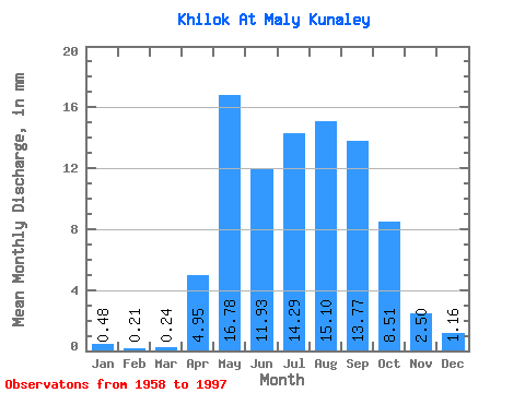
| Statistic | Jan | Feb | Mar | Apr | May | Jun | Jul | Aug | Sep | Oct | Nov | Dec | Annual |
|---|---|---|---|---|---|---|---|---|---|---|---|---|---|
| Mean | 0.48 | 0.21 | 0.24 | 4.95 | 16.78 | 11.93 | 14.29 | 15.10 | 13.77 | 8.51 | 2.50 | 1.16 | 90.35 |
| Standard Deviation | 0.41 | 0.19 | 0.20 | 2.69 | 8.19 | 7.46 | 9.03 | 9.55 | 9.63 | 5.13 | 1.34 | 0.80 | 35.69 |
| Min | 0.03 | 0.00 | 0.01 | 0.43 | 5.92 | 0.87 | 3.46 | 3.08 | 3.03 | 2.05 | 0.34 | 0.17 | 32.67 |
| Max | 1.56 | 0.65 | 0.69 | 13.31 | 39.17 | 35.99 | 39.08 | 37.37 | 42.73 | 27.50 | 6.01 | 3.18 | 160.74 |
| Coefficient of Variation | 0.85 | 0.89 | 0.85 | 0.54 | 0.49 | 0.62 | 0.63 | 0.63 | 0.70 | 0.60 | 0.54 | 0.69 | 0.40 |
 Return to R-Arctic Net Home Page