|
|
|||||||||||||||||
| Point ID: 6429 | Downloads | Plots | Site Data | Code: 7099 |
|
|
|||||||||||||||||
| Download | |
|---|---|
| Site Descriptor Information | Site Time Series Data |
| Link to all available data | |
|
|
| View: | Statistics | Time Series |
| Units: | mm |
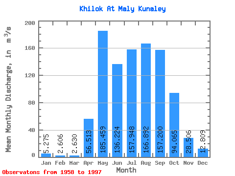
| Statistic | Jan | Feb | Mar | Apr | May | Jun | Jul | Aug | Sep | Oct | Nov | Dec | Annual |
|---|---|---|---|---|---|---|---|---|---|---|---|---|---|
| Mean | 5.28 | 2.61 | 2.63 | 56.51 | 185.46 | 136.22 | 157.95 | 166.89 | 157.20 | 94.06 | 28.51 | 12.81 | 84.74 |
| Standard Deviation | 4.49 | 2.32 | 2.23 | 30.72 | 90.53 | 85.18 | 99.79 | 105.61 | 109.95 | 56.65 | 15.35 | 8.86 | 33.47 |
| Min | 0.31 | 0.01 | 0.09 | 4.89 | 65.40 | 9.95 | 38.20 | 34.10 | 34.60 | 22.70 | 3.92 | 1.85 | 30.64 |
| Max | 17.20 | 7.84 | 7.67 | 152.00 | 433.00 | 411.00 | 432.00 | 413.00 | 488.00 | 304.00 | 68.60 | 35.10 | 150.75 |
| Coefficient of Variation | 0.85 | 0.89 | 0.85 | 0.54 | 0.49 | 0.62 | 0.63 | 0.63 | 0.70 | 0.60 | 0.54 | 0.69 | 0.40 |
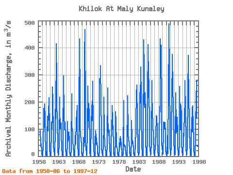
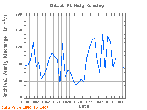
| Year | Jan | Feb | Mar | Apr | May | Jun | Jul | Aug | Sep | Oct | Nov | Dec | Annual | 1958 | 88.80 | 94.20 | 43.90 | 36.90 | 45.60 | 18.40 | 5.48 | 1959 | 2.04 | 0.97 | 1.00 | 41.70 | 140.00 | 176.00 | 106.00 | 193.00 | 138.00 | 102.00 | 3.92 | 16.40 | 76.75 | 1960 | 3.54 | 1.77 | 1.28 | 68.70 | 147.00 | 94.50 | 108.00 | 155.00 | 216.00 | 98.60 | 26.00 | 9.09 | 77.46 | 1961 | 3.13 | 1.70 | 2.48 | 98.40 | 126.00 | 100.00 | 147.00 | 255.00 | 203.00 | 90.20 | 35.90 | 23.20 | 90.50 | 1962 | 7.51 | 3.41 | 3.33 | 103.00 | 242.00 | 138.00 | 415.00 | 273.00 | 197.00 | 132.00 | 36.20 | 15.80 | 130.52 | 1963 | 9.31 | 5.95 | 7.01 | 50.00 | 217.00 | 103.00 | 139.00 | 101.00 | 122.00 | 90.10 | 24.30 | 12.90 | 73.46 | 1964 | 5.68 | 2.15 | 1.78 | 56.40 | 297.00 | 153.00 | 160.00 | 97.80 | 125.00 | 67.20 | 26.20 | 9.91 | 83.51 | 1965 | 3.47 | 2.12 | 2.38 | 49.30 | 128.00 | 54.90 | 62.50 | 74.70 | 88.00 | 57.40 | 20.90 | 6.99 | 45.89 | 1966 | 2.42 | 1.35 | 1.06 | 25.90 | 231.00 | 110.00 | 96.00 | 91.10 | 49.30 | 39.30 | 12.10 | 2.63 | 55.18 | 1967 | 0.34 | 0.01 | 0.29 | 76.00 | 77.00 | 45.20 | 137.00 | 149.00 | 188.00 | 118.00 | 37.80 | 13.60 | 70.19 | 1968 | 6.91 | 3.30 | 4.34 | 152.00 | 433.00 | 207.00 | 111.00 | 75.60 | 61.70 | 42.80 | 13.70 | 4.67 | 93.00 | 1969 | 1.26 | 0.29 | 0.39 | 24.50 | 69.70 | 36.80 | 61.60 | 375.00 | 467.00 | 159.00 | 45.20 | 29.90 | 105.89 | 1970 | 13.00 | 5.34 | 3.72 | 92.50 | 259.00 | 133.00 | 150.00 | 107.00 | 195.00 | 155.00 | 45.30 | 13.40 | 97.69 | 1971 | 4.18 | 2.05 | 1.69 | 127.00 | 165.00 | 189.00 | 131.00 | 276.00 | 99.00 | 67.90 | 23.60 | 6.72 | 91.09 | 1972 | 1.71 | 0.89 | 0.81 | 53.10 | 94.10 | 44.70 | 82.20 | 55.40 | 46.00 | 31.30 | 11.20 | 2.88 | 35.36 | 1973 | 0.90 | 0.41 | 0.43 | 20.90 | 286.00 | 280.00 | 272.00 | 334.00 | 200.00 | 95.50 | 31.90 | 15.40 | 128.12 | 1974 | 5.90 | 2.28 | 1.88 | 47.70 | 106.00 | 218.00 | 87.50 | 46.30 | 38.60 | 31.60 | 9.05 | 1.85 | 49.72 | 1975 | 0.58 | 0.21 | 0.24 | 45.60 | 251.00 | 138.00 | 100.00 | 76.10 | 95.90 | 66.80 | 23.50 | 5.81 | 66.98 | 1976 | 1.06 | 0.51 | 0.86 | 17.00 | 133.00 | 101.00 | 188.00 | 133.00 | 91.30 | 52.90 | 9.94 | 3.53 | 61.01 | 1977 | 0.95 | 0.17 | 0.23 | 64.90 | 164.00 | 128.00 | 47.80 | 34.40 | 34.60 | 22.70 | 9.42 | 3.46 | 42.55 | 1978 | 1.12 | 0.34 | 0.58 | 32.90 | 65.40 | 35.20 | 71.90 | 42.00 | 63.50 | 38.80 | 12.70 | 3.21 | 30.64 | 1979 | 0.87 | 0.50 | 0.73 | 9.73 | 205.00 | 51.80 | 38.20 | 34.10 | 38.30 | 28.90 | 11.00 | 2.73 | 35.16 | 1980 | 0.31 | 0.04 | 0.09 | 4.89 | 224.00 | 85.50 | 76.20 | 67.70 | 43.30 | 30.90 | 12.20 | 4.74 | 45.82 | 1981 | 1.21 | 0.36 | 0.83 | 65.60 | 132.00 | 65.20 | 46.90 | 58.70 | 48.30 | 29.50 | 12.90 | 4.41 | 38.83 | 1982 | 0.92 | 0.03 | 0.28 | 53.50 | 84.90 | 110.00 | 245.00 | 196.00 | 263.00 | 128.00 | 34.00 | 16.20 | 94.32 | 1983 | 8.05 | 5.19 | 3.59 | 16.60 | 180.00 | 233.00 | 196.00 | 328.00 | 218.00 | 147.00 | 36.30 | 17.00 | 115.73 | 1984 | 7.02 | 3.22 | 2.69 | 29.40 | 429.00 | 321.00 | 200.00 | 180.00 | 234.00 | 152.00 | 45.10 | 18.70 | 135.18 | 1985 | 5.12 | 2.10 | 1.93 | 72.80 | 211.00 | 411.00 | 216.00 | 348.00 | 216.00 | 145.00 | 41.80 | 25.00 | 141.31 | 1986 | 11.90 | 6.82 | 5.95 | 53.40 | 279.00 | 219.00 | 171.00 | 109.00 | 132.00 | 57.80 | 25.70 | 14.20 | 90.48 | 1987 | 5.07 | 2.98 | 1.84 | 43.40 | 95.20 | 71.70 | 149.00 | 145.00 | 98.30 | 65.40 | 17.80 | 5.59 | 58.44 | 1988 | 2.48 | 1.19 | 1.18 | 60.10 | 183.00 | 164.00 | 432.00 | 311.00 | 409.00 | 166.00 | 50.00 | 29.10 | 150.75 | 1989 | 17.20 | 7.32 | 7.67 | 91.80 | 126.00 | 102.00 | 102.00 | 124.00 | 125.00 | 81.10 | 26.30 | 10.30 | 68.39 | 1990 | 4.18 | 1.79 | 4.12 | 61.70 | 90.40 | 9.95 | 262.00 | 413.00 | 488.00 | 304.00 | 68.60 | 35.10 | 145.24 | 1991 | 16.80 | 7.84 | 5.93 | 39.70 | 286.00 | 180.00 | 375.00 | 248.00 | 187.00 | 147.00 | 48.60 | 25.70 | 130.63 | 1992 | 9.23 | 5.69 | 5.76 | 59.10 | 233.00 | 109.00 | 85.40 | 93.90 | 144.00 | 84.50 | 27.30 | 17.50 | 72.86 | 1993 | 8.30 | 3.53 | 6.67 | 59.00 | 258.00 | 99.90 | 97.50 | 192.00 | 181.00 | 156.00 | 47.00 | 16.80 | 93.81 | 1994 | 8.00 | 5.29 | 5.17 | 63.30 | 106.00 | 73.70 | 171.00 | 184.00 | 278.00 | 160.00 | 56.90 | 28.50 | 94.99 | 1995 | 12.50 | 6.90 | 6.10 | 38.10 | 248.00 | 238.00 | 372.00 | 193.00 | 159.00 | 95.20 | 42.50 | 16.10 | 118.95 | 1996 | 6.28 | 3.26 | 2.97 | 57.80 | 143.00 | 91.10 | 174.00 | 186.00 | 109.00 | 67.60 | 21.20 | 11.90 | 72.84 | 1997 | 5.27 | 2.35 | 3.29 | 76.60 | 88.20 | 239.00 | 141.00 | 276.00 | 161.00 | 112.00 | 37.80 | 5.97 | 95.71 |
|---|
 Return to R-Arctic Net Home Page