|
|
|||||||||||||||||
| Point ID: 6354 | Downloads | Plots | Site Data | Other Close Sites | Code: 3881 |
|
|
|||||||||||||||||
| Download | |
|---|---|
| Site Descriptor Information | Site Time Series Data |
| Link to all available data | |
|
|
| View: | Statistics | Time Series |
| Units: | mm |
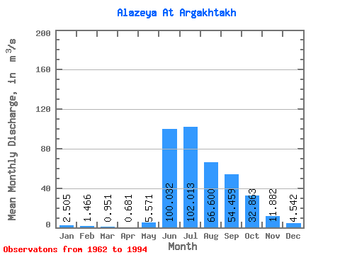
| Statistic | Jan | Feb | Mar | Apr | May | Jun | Jul | Aug | Sep | Oct | Nov | Dec | Annual |
|---|---|---|---|---|---|---|---|---|---|---|---|---|---|
| Mean | 2.50 | 1.47 | 0.95 | 0.68 | 5.57 | 100.03 | 102.01 | 66.60 | 54.46 | 32.86 | 11.88 | 4.54 | 31.96 |
| Standard Deviation | 2.69 | 1.88 | 1.33 | 0.94 | 6.26 | 38.56 | 50.95 | 46.29 | 46.70 | 38.56 | 13.47 | 4.04 | 15.46 |
| Min | 0.00 | 0.00 | 0.00 | 0.00 | 0.07 | 24.80 | 10.40 | 9.20 | 6.78 | 3.46 | 0.99 | 0.03 | 5.62 |
| Max | 10.80 | 8.05 | 5.46 | 4.13 | 24.90 | 156.00 | 183.00 | 158.00 | 184.00 | 154.00 | 60.30 | 16.60 | 66.08 |
| Coefficient of Variation | 1.07 | 1.28 | 1.40 | 1.38 | 1.12 | 0.39 | 0.50 | 0.69 | 0.86 | 1.17 | 1.13 | 0.89 | 0.48 |
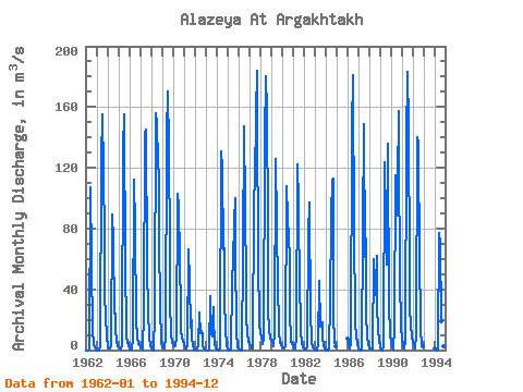
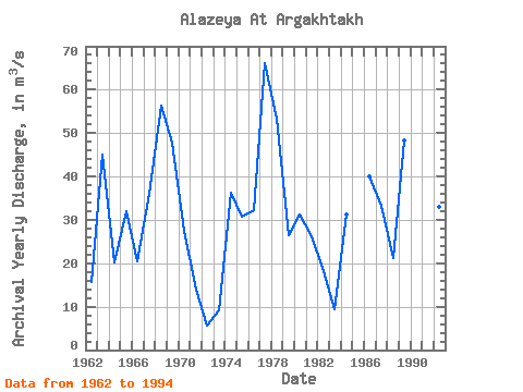
| Year | Jan | Feb | Mar | Apr | May | Jun | Jul | Aug | Sep | Oct | Nov | Dec | Annual | 1962 | 0.00 | 0.00 | 0.00 | 0.00 | 0.50 | 107.00 | 59.20 | 10.20 | 6.78 | 3.92 | 1.57 | 0.03 | 15.77 | 1963 | 0.00 | 0.00 | 0.00 | 0.00 | 2.40 | 125.00 | 155.00 | 118.00 | 71.80 | 36.80 | 22.00 | 9.03 | 45.00 | 1964 | 2.64 | 1.35 | 1.15 | 1.00 | 3.40 | 89.60 | 72.00 | 23.90 | 24.10 | 14.80 | 5.19 | 2.24 | 20.11 | 1965 | 1.51 | 0.93 | 0.69 | 0.53 | 3.64 | 133.00 | 155.00 | 53.30 | 17.00 | 8.92 | 5.09 | 2.77 | 31.86 | 1966 | 1.16 | 0.48 | 0.14 | 0.07 | 7.71 | 112.00 | 81.70 | 17.10 | 10.90 | 7.89 | 4.27 | 2.93 | 20.53 | 1967 | 2.14 | 0.84 | 0.22 | 0.05 | 24.90 | 142.00 | 145.00 | 57.30 | 23.20 | 25.40 | 8.60 | 3.41 | 36.09 | 1968 | 1.07 | 0.01 | 0.00 | 0.00 | 24.30 | 156.00 | 149.00 | 124.00 | 114.00 | 72.70 | 29.30 | 5.62 | 56.33 | 1969 | 1.80 | 1.59 | 1.33 | 1.08 | 8.95 | 142.00 | 170.00 | 134.00 | 65.50 | 33.20 | 9.52 | 5.70 | 47.89 | 1970 | 3.57 | 2.98 | 2.88 | 2.63 | 8.12 | 103.00 | 94.20 | 60.20 | 26.20 | 12.70 | 8.31 | 5.46 | 27.52 | 1971 | 4.10 | 1.22 | 0.37 | 0.62 | 3.39 | 66.10 | 45.30 | 15.00 | 20.00 | 8.05 | 2.87 | 0.66 | 13.97 | 1972 | 0.22 | 0.03 | 0.00 | 0.26 | 3.71 | 24.80 | 11.40 | 12.90 | 9.54 | 3.46 | 0.99 | 0.13 | 5.62 | 1973 | 0.00 | 0.00 | 0.00 | 0.00 | 0.67 | 35.50 | 10.40 | 9.20 | 28.50 | 20.90 | 4.09 | 1.17 | 9.20 | 1974 | 0.20 | 0.01 | 0.00 | 0.00 | 1.83 | 131.00 | 119.00 | 66.00 | 67.00 | 34.30 | 13.60 | 3.30 | 36.35 | 1975 | 0.08 | 0.00 | 0.00 | 0.02 | 0.21 | 45.00 | 59.00 | 84.40 | 100.00 | 66.60 | 11.40 | 2.76 | 30.79 | 1976 | 0.54 | 0.01 | 0.00 | 0.00 | 0.07 | 63.70 | 147.00 | 95.00 | 41.90 | 22.20 | 11.10 | 5.88 | 32.28 | 1977 | 4.01 | 2.90 | 2.68 | 1.19 | 0.94 | 99.40 | 111.00 | 156.00 | 184.00 | 154.00 | 60.30 | 16.60 | 66.08 | 1978 | 10.80 | 8.05 | 5.46 | 4.13 | 7.09 | 139.00 | 180.00 | 158.00 | 80.40 | 27.30 | 12.30 | 7.98 | 53.38 | 1979 | 6.38 | 5.32 | 3.81 | 2.27 | 10.80 | 126.00 | 83.80 | 40.10 | 18.60 | 11.90 | 4.35 | 3.39 | 26.39 | 1980 | 2.47 | 1.75 | 1.45 | 1.39 | 3.58 | 108.00 | 86.50 | 74.20 | 60.60 | 24.80 | 6.08 | 3.72 | 31.21 | 1981 | 2.77 | 1.25 | 1.10 | 1.19 | 8.88 | 122.00 | 96.60 | 35.60 | 25.70 | 12.10 | 4.57 | 2.03 | 26.15 | 1982 | 0.84 | 0.68 | 0.46 | 0.70 | 2.64 | 75.90 | 97.40 | 21.30 | 10.40 | 5.27 | 1.78 | 0.76 | 18.18 | 1983 | 0.03 | 0.00 | 0.00 | 0.00 | 4.42 | 45.20 | 15.50 | 17.60 | 18.20 | 7.80 | 3.13 | 1.18 | 9.42 | 1984 | 0.14 | 0.00 | 0.00 | 0.00 | 0.87 | 30.90 | 88.00 | 112.00 | 113.00 | 23.00 | 5.65 | 2.41 | 31.33 | 1986 | 7.19 | 4.37 | 2.57 | 1.32 | 4.86 | 146.00 | 181.00 | 73.20 | 27.10 | 18.50 | 8.99 | 4.67 | 39.98 | 1987 | 1.43 | 0.39 | 0.00 | 0.00 | 0.23 | 78.90 | 149.00 | 61.60 | 73.30 | 23.90 | 8.70 | 2.95 | 33.37 | 1988 | 1.47 | 1.19 | 0.59 | 0.28 | 0.92 | 59.60 | 36.20 | 43.50 | 62.30 | 29.20 | 13.40 | 6.42 | 21.26 | 1989 | 2.19 | 0.61 | 0.00 | 0.00 | 3.55 | 124.00 | 86.70 | 56.50 | 136.00 | 131.00 | 29.40 | 9.86 | 48.32 | 1990 | 5.79 | 3.03 | 1.33 | 0.67 | 14.40 | 115.00 | 88.20 | 111.00 | 157.00 | 129.00 | 47.70 | 15.20 | 57.36 | 1991 | 7.34 | 3.30 | 1.34 | 0.78 | 5.80 | 138.00 | 183.00 | 147.00 | 54.00 | 27.30 | 17.10 | 9.05 | 49.50 | 1992 | 5.02 | 2.94 | 1.90 | 0.94 | 9.82 | 140.00 | 136.00 | 57.60 | 22.60 | 12.70 | 4.47 | 2.76 | 33.06 | 1994 | 0.76 | 0.23 | 0.02 | 0.00 | 0.09 | 77.40 | 70.30 | 18.90 | 18.60 | 9.15 | 2.53 | 0.73 | 16.56 |
|---|
| Other Close Sites | ||||||
|---|---|---|---|---|---|---|
| PointID | Latitude | Longitude | Drainage Area | Source | Name | |
| 6313 | "Alazeya At Argakhtakh" | 68.50 | 2125574 | SHI | ||
 Return to R-Arctic Net Home Page