|
|
|||||||||||||||||
| Point ID: 6354 | Downloads | Plots | Site Data | Other Close Sites | Code: 3881 |
|
|
|||||||||||||||||
| Download | |
|---|---|
| Site Descriptor Information | Site Time Series Data |
| Link to all available data | |
| View: | Time Series | All |
| Units: | mm |
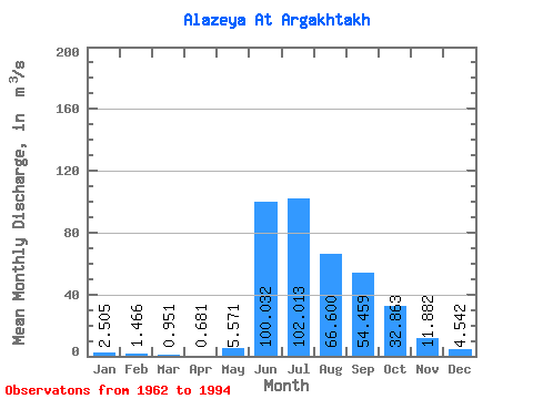
| Statistic | Jan | Feb | Mar | Apr | May | Jun | Jul | Aug | Sep | Oct | Nov | Dec | Annual |
|---|---|---|---|---|---|---|---|---|---|---|---|---|---|
| Mean | 2.50 | 1.47 | 0.95 | 0.68 | 5.57 | 100.03 | 102.01 | 66.60 | 54.46 | 32.86 | 11.88 | 4.54 | 31.96 |
| Standard Deviation | 2.69 | 1.88 | 1.33 | 0.94 | 6.26 | 38.56 | 50.95 | 46.29 | 46.70 | 38.56 | 13.47 | 4.04 | 15.46 |
| Min | 0.00 | 0.00 | 0.00 | 0.00 | 0.07 | 24.80 | 10.40 | 9.20 | 6.78 | 3.46 | 0.99 | 0.03 | 5.62 |
| Max | 10.80 | 8.05 | 5.46 | 4.13 | 24.90 | 156.00 | 183.00 | 158.00 | 184.00 | 154.00 | 60.30 | 16.60 | 66.08 |
| Coefficient of Variation | 1.07 | 1.28 | 1.40 | 1.38 | 1.12 | 0.39 | 0.50 | 0.69 | 0.86 | 1.17 | 1.13 | 0.89 | 0.48 |
| Other Close Sites | ||||||
|---|---|---|---|---|---|---|
| PointID | Latitude | Longitude | Drainage Area | Source | Name | |
| 6313 | "Alazeya At Argakhtakh" | 68.50 | 2125574 | SHI | ||
 Return to R-Arctic Net Home Page