|
|
|||||||||||||||||
| Point ID: 632 | Downloads | Plots | Site Data | Code: 07AG003 |
|
|
|||||||||||||||||
| Download | |
|---|---|
| Site Descriptor Information | Site Time Series Data |
| Link to all available data | |
| View: | Time Series | All |
| Units: | m3/s |
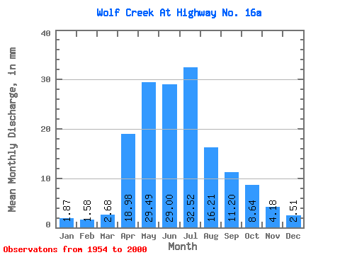
| Statistic | Jan | Feb | Mar | Apr | May | Jun | Jul | Aug | Sep | Oct | Nov | Dec | Annual |
|---|---|---|---|---|---|---|---|---|---|---|---|---|---|
| Mean | 1.81 | 1.55 | 2.60 | 18.43 | 28.64 | 28.16 | 31.57 | 15.74 | 10.87 | 8.39 | 4.06 | 2.44 | 153.64 |
| Standard Deviation | 0.83 | 0.66 | 2.42 | 11.19 | 18.66 | 26.19 | 32.97 | 18.41 | 10.95 | 6.49 | 2.53 | 1.24 | 72.29 |
| Min | 0.14 | 0.07 | 0.27 | 4.78 | 3.81 | 5.22 | 3.14 | 1.90 | 1.22 | 1.32 | 1.08 | 0.25 | 49.54 |
| Max | 4.30 | 2.92 | 16.09 | 49.09 | 95.62 | 134.76 | 171.86 | 88.19 | 44.71 | 32.63 | 10.82 | 5.88 | 354.10 |
| Coefficient of Variation | 0.46 | 0.42 | 0.93 | 0.61 | 0.65 | 0.93 | 1.04 | 1.17 | 1.01 | 0.77 | 0.62 | 0.51 | 0.47 |
 Return to R-Arctic Net Home Page