|
|
|||||||||||||||||
| Point ID: 632 | Downloads | Plots | Site Data | Code: 07AG003 |
|
|
|||||||||||||||||
| Download | |
|---|---|
| Site Descriptor Information | Site Time Series Data |
| Link to all available data | |
| View: | Time Series | All |
| Units: | mm |
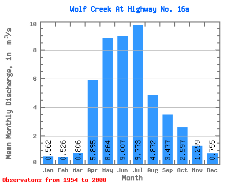
| Statistic | Jan | Feb | Mar | Apr | May | Jun | Jul | Aug | Sep | Oct | Nov | Dec | Annual |
|---|---|---|---|---|---|---|---|---|---|---|---|---|---|
| Mean | 0.56 | 0.53 | 0.81 | 5.89 | 8.86 | 9.01 | 9.77 | 4.87 | 3.48 | 2.60 | 1.30 | 0.76 | 4.04 |
| Standard Deviation | 0.26 | 0.22 | 0.75 | 3.58 | 5.78 | 8.38 | 10.21 | 5.70 | 3.50 | 2.01 | 0.81 | 0.39 | 1.90 |
| Min | 0.04 | 0.02 | 0.08 | 1.53 | 1.18 | 1.67 | 0.97 | 0.59 | 0.39 | 0.41 | 0.34 | 0.08 | 1.30 |
| Max | 1.33 | 0.99 | 4.98 | 15.70 | 29.60 | 43.10 | 53.20 | 27.30 | 14.30 | 10.10 | 3.46 | 1.82 | 9.30 |
| Coefficient of Variation | 0.46 | 0.42 | 0.93 | 0.61 | 0.65 | 0.93 | 1.04 | 1.17 | 1.01 | 0.77 | 0.62 | 0.51 | 0.47 |
 Return to R-Arctic Net Home Page