|
|
|||||||||||||||||
| Point ID: 6315 | Downloads | Plots | Site Data | Code: 3555 |
|
|
|||||||||||||||||
| Download | |
|---|---|
| Site Descriptor Information | Site Time Series Data |
| Link to all available data | |
|
|
| View: | Statistics | Time Series |
| Units: | mm |
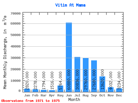
| Statistic | Jan | Feb | Mar | Apr | May | Jun | Jul | Aug | Sep | Oct | Nov | Dec | Annual |
|---|---|---|---|---|---|---|---|---|---|---|---|---|---|
| Mean | 2820.00 | 2278.00 | 1794.00 | 1516.00 | 5764.00 | 60880.00 | 30836.00 | 29760.00 | 27680.00 | 13620.00 | 4032.00 | 3234.00 | 15351.17 |
| Standard Deviation | 277.22 | 329.57 | 423.59 | 285.88 | 4555.78 | 4859.23 | 17008.34 | 7063.50 | 4132.43 | 2593.64 | 933.87 | 462.15 | 1652.96 |
| Min | 2480.00 | 1900.00 | 1250.00 | 1050.00 | 2270.00 | 54300.00 | 2780.00 | 22900.00 | 22000.00 | 10400.00 | 3230.00 | 2740.00 | 13093.33 |
| Max | 3190.00 | 2620.00 | 2160.00 | 1750.00 | 13700.00 | 67300.00 | 49000.00 | 37500.00 | 31600.00 | 16900.00 | 5610.00 | 3920.00 | 17699.17 |
| Coefficient of Variation | 0.10 | 0.14 | 0.24 | 0.19 | 0.79 | 0.08 | 0.55 | 0.24 | 0.15 | 0.19 | 0.23 | 0.14 | 0.11 |
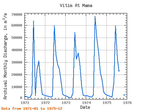
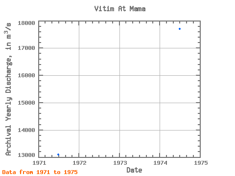
| Year | Jan | Feb | Mar | Apr | May | Jun | Jul | Aug | Sep | Oct | Nov | Dec | Annual | 1971 | 2480.00 | 1950.00 | 1430.00 | 1440.00 | 4610.00 | 63500.00 | 2780.00 | 23800.00 | 30900.00 | 16900.00 | 3870.00 | 3460.00 | 13093.33 | 1972 | 2980.00 | 2480.00 | 2130.00 | 1700.00 | 2270.00 | 59800.00 | 36300.00 | 27600.00 | 24800.00 | 13600.00 | 3990.00 | 3000.00 | 15054.17 | 1973 | 2650.00 | 1900.00 | 1250.00 | 1050.00 | 4860.00 | 54300.00 | 32600.00 | 37500.00 | 29100.00 | 10400.00 | 3230.00 | 2740.00 | 15131.67 | 1974 | 2800.00 | 2440.00 | 2000.00 | 1640.00 | 3380.00 | 67300.00 | 49000.00 | 37000.00 | 22000.00 | 15300.00 | 5610.00 | 3920.00 | 17699.17 | 1975 | 3190.00 | 2620.00 | 2160.00 | 1750.00 | 13700.00 | 59500.00 | 33500.00 | 22900.00 | 31600.00 | 11900.00 | 3460.00 | 3050.00 | 15777.50 |
|---|
 Return to R-Arctic Net Home Page