|
|
|||||||||||||||||
| Point ID: 6315 | Downloads | Plots | Site Data | Code: 3555 |
|
|
|||||||||||||||||
| Download | |
|---|---|
| Site Descriptor Information | Site Time Series Data |
| Link to all available data | |
|
|
| View: | Statistics | Time Series |
| Units: | m3/s |
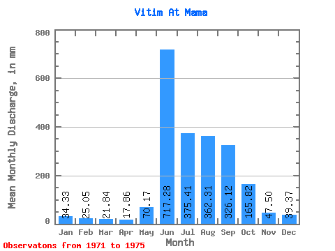
| Statistic | Jan | Feb | Mar | Apr | May | Jun | Jul | Aug | Sep | Oct | Nov | Dec | Annual |
|---|---|---|---|---|---|---|---|---|---|---|---|---|---|
| Mean | 34.33 | 25.27 | 21.84 | 17.86 | 70.16 | 717.28 | 375.36 | 362.26 | 326.12 | 165.79 | 47.50 | 39.37 | 2202.20 |
| Standard Deviation | 3.38 | 3.66 | 5.16 | 3.37 | 55.46 | 57.25 | 207.04 | 85.98 | 48.69 | 31.57 | 11.00 | 5.63 | 237.12 |
| Min | 30.19 | 21.07 | 15.22 | 12.37 | 27.63 | 639.75 | 33.84 | 278.75 | 259.20 | 126.60 | 38.05 | 33.35 | 1878.30 |
| Max | 38.83 | 29.06 | 26.29 | 20.62 | 166.77 | 792.92 | 596.46 | 456.48 | 372.31 | 205.72 | 66.10 | 47.72 | 2539.03 |
| Coefficient of Variation | 0.10 | 0.14 | 0.24 | 0.19 | 0.79 | 0.08 | 0.55 | 0.24 | 0.15 | 0.19 | 0.23 | 0.14 | 0.11 |
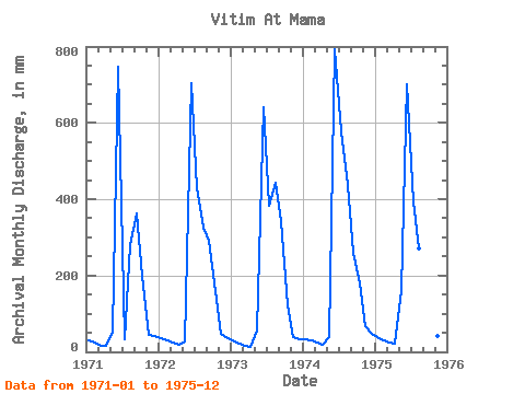
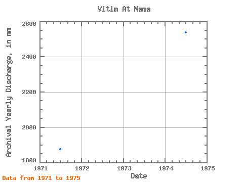
| Year | Jan | Feb | Mar | Apr | May | Jun | Jul | Aug | Sep | Oct | Nov | Dec | Annual | 1971 | 30.19 | 21.63 | 17.41 | 16.97 | 56.12 | 748.14 | 33.84 | 289.71 | 364.06 | 205.72 | 45.60 | 42.12 | 1878.30 | 1972 | 36.27 | 27.50 | 25.93 | 20.03 | 27.63 | 704.55 | 441.87 | 335.97 | 292.19 | 165.55 | 47.01 | 36.52 | 2159.59 | 1973 | 32.26 | 21.07 | 15.22 | 12.37 | 59.16 | 639.75 | 396.83 | 456.48 | 342.85 | 126.60 | 38.05 | 33.35 | 2170.71 | 1974 | 34.08 | 27.06 | 24.34 | 19.32 | 41.14 | 792.92 | 596.46 | 450.39 | 259.20 | 186.24 | 66.10 | 47.72 | 2539.03 | 1975 | 38.83 | 29.06 | 26.29 | 20.62 | 166.77 | 701.02 | 407.79 | 278.75 | 372.31 | 144.85 | 40.77 | 37.13 | 2263.35 |
|---|
 Return to R-Arctic Net Home Page