|
|
|||||||||||||||||
| Point ID: 6268 | Downloads | Plots | Site Data | Other Close Sites | Code: 3334 |
|
|
|||||||||||||||||
| Download | |
|---|---|
| Site Descriptor Information | Site Time Series Data |
| Link to all available data | |
|
|
| View: | Statistics | Time Series |
| Units: | mm |
| Statistic | Jan | Feb | Mar | Apr | May | Jun | Jul | Aug | Sep | Oct | Nov | Dec | Annual |
|---|---|---|---|---|---|---|---|---|---|---|---|---|---|
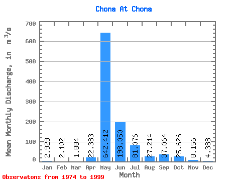
| Mean | 2.93 | 2.10 | 1.88 | 22.38 | 642.41 | 198.05 | 81.08 | 27.21 | 37.06 | 25.63 | 8.16 | 4.39 | 86.89 |
| Standard Deviation | 1.67 | 1.17 | 1.03 | 74.91 | 208.40 | 122.23 | 123.98 | 14.03 | 18.69 | 13.29 | 4.71 | 1.92 | 25.09 |
| Min | 0.56 | 0.50 | 0.78 | 0.89 | 4.29 | 2.96 | 10.50 | 9.66 | 12.80 | 2.36 | 3.69 | 1.55 | 10.21 |
| Max | 7.63 | 5.41 | 5.40 | 367.00 | 908.00 | 460.00 | 637.00 | 59.70 | 84.80 | 61.30 | 25.40 | 10.60 | 124.97 |
| Coefficient of Variation | 0.57 | 0.56 | 0.55 | 3.35 | 0.32 | 0.62 | 1.53 | 0.52 | 0.50 | 0.52 | 0.58 | 0.44 | 0.29 |
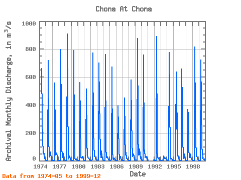
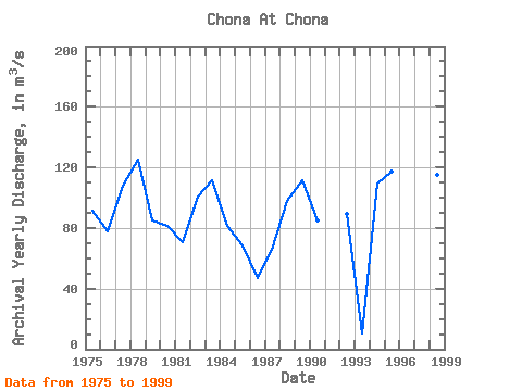
| Year | Jan | Feb | Mar | Apr | May | Jun | Jul | Aug | Sep | Oct | Nov | Dec | Annual | 1974 | 663.00 | 295.00 | 156.00 | 47.10 | 66.30 | 41.60 | 5.83 | 5.09 | 1975 | 2.62 | 1.48 | 1.40 | 12.60 | 718.00 | 172.00 | 26.00 | 33.30 | 55.00 | 61.30 | 6.10 | 2.98 | 91.06 | 1976 | 3.70 | 2.90 | 2.13 | 2.68 | 559.00 | 175.00 | 41.50 | 55.10 | 54.00 | 31.60 | 4.01 | 3.32 | 77.91 | 1977 | 1.51 | 1.32 | 2.17 | 2.68 | 796.00 | 294.00 | 102.00 | 23.50 | 52.60 | 2.36 | 8.42 | 3.78 | 107.53 | 1978 | 2.60 | 1.88 | 2.47 | 4.81 | 908.00 | 419.00 | 68.50 | 12.70 | 35.00 | 30.30 | 10.40 | 3.96 | 124.97 | 1979 | 2.64 | 2.07 | 1.71 | 4.31 | 790.00 | 156.00 | 16.60 | 10.40 | 12.80 | 13.50 | 3.69 | 4.22 | 84.83 | 1980 | 2.64 | 1.69 | 1.64 | 2.88 | 560.00 | 296.00 | 21.80 | 20.80 | 30.40 | 27.90 | 7.32 | 3.44 | 81.38 | 1981 | 2.08 | 1.48 | 1.31 | 76.10 | 513.00 | 136.00 | 42.90 | 22.10 | 21.50 | 19.10 | 7.49 | 4.24 | 70.61 | 1982 | 2.74 | 2.16 | 2.08 | 11.20 | 774.00 | 202.00 | 116.00 | 31.80 | 35.30 | 19.20 | 7.35 | 5.32 | 100.76 | 1983 | 4.97 | 4.09 | 3.67 | 3.72 | 699.00 | 427.00 | 61.50 | 22.00 | 68.60 | 26.80 | 10.80 | 6.81 | 111.58 | 1984 | 4.79 | 2.27 | 2.49 | 2.18 | 761.00 | 100.00 | 24.80 | 30.40 | 21.80 | 14.70 | 4.78 | 3.63 | 81.07 | 1985 | 2.94 | 2.67 | 1.16 | 8.21 | 671.00 | 74.00 | 11.80 | 9.66 | 20.50 | 13.40 | 6.06 | 2.22 | 68.64 | 1986 | 0.56 | 0.50 | 1.64 | 2.59 | 391.00 | 79.90 | 10.50 | 22.50 | 32.10 | 14.00 | 4.18 | 3.68 | 46.93 | 1987 | 1.35 | 1.78 | 1.19 | 1.84 | 451.00 | 189.00 | 41.90 | 59.70 | 14.90 | 14.70 | 5.22 | 3.07 | 65.47 | 1988 | 2.93 | 1.35 | 1.17 | 4.72 | 580.00 | 285.00 | 145.00 | 31.20 | 40.50 | 49.80 | 25.40 | 6.93 | 97.83 | 1989 | 6.11 | 5.41 | 5.40 | 6.25 | 875.00 | 194.00 | 41.60 | 44.00 | 84.80 | 44.90 | 15.50 | 10.60 | 111.13 | 1990 | 7.63 | 4.07 | 1.98 | 5.05 | 758.00 | 70.50 | 78.70 | 22.30 | 28.90 | 26.70 | 8.00 | 6.76 | 84.88 | 1992 | 4.13 | 3.44 | 2.63 | 2.84 | 892.00 | 70.80 | 27.90 | 13.70 | 21.00 | 24.10 | 5.82 | 3.37 | 89.31 | 1993 | 2.97 | 2.20 | 2.73 | 5.38 | 4.29 | 2.96 | 35.00 | 15.70 | 20.10 | 15.00 | 10.50 | 5.69 | 10.21 | 1994 | 3.78 | 2.09 | 1.49 | 2.74 | 775.00 | 460.00 | 19.80 | 11.80 | 17.80 | 15.70 | 4.00 | 1.55 | 109.65 | 1995 | 1.08 | 0.93 | 0.96 | 1.12 | 402.00 | 226.00 | 637.00 | 48.40 | 33.50 | 35.20 | 13.30 | 3.72 | 116.93 | 1996 | 1.40 | 0.94 | 0.81 | 0.89 | 656.00 | 131.00 | 62.30 | 15.80 | 49.90 | 29.20 | 3.89 | 1.84 | 79.50 | 1997 | 1.54 | 1.12 | 0.78 | 367.00 | 324.00 | 93.10 | 22.60 | 25.60 | 50.00 | 28.00 | 10.50 | 5.12 | 77.45 | 1998 | 1.43 | 0.99 | 1.05 | 2.95 | 816.00 | 302.00 | 154.00 | 29.50 | 34.50 | 24.30 | 8.12 | 3.91 | 114.90 | 1999 | 2.12 | 1.61 | 1.15 | 2.46 | 724.00 | 101.00 | 61.20 | 21.30 | 24.80 | 17.30 | 7.23 | 4.46 | 80.72 |
|---|
| Other Close Sites | ||||||
|---|---|---|---|---|---|---|
| PointID | Latitude | Longitude | Drainage Area | Source | Name | |
| 6269 | "Chona At Ust'-Markhaya" | 61.98 | 1042418 | SHI | 274.00 | |
 Return to R-Arctic Net Home Page