|
|
|||||||||||||||||
| Point ID: 6172 | Downloads | Plots | Site Data | Other Close Sites | Code: 3100 |
|
|
|||||||||||||||||
| Download | |
|---|---|
| Site Descriptor Information | Site Time Series Data |
| Link to all available data | |
|
|
| View: | Statistics | Time Series |
| Units: | mm |
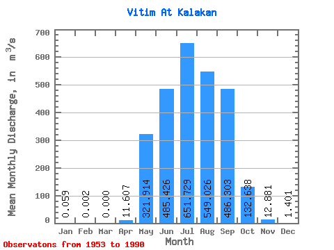
| Statistic | Jan | Feb | Mar | Apr | May | Jun | Jul | Aug | Sep | Oct | Nov | Dec | Annual |
|---|---|---|---|---|---|---|---|---|---|---|---|---|---|
| Mean | 0.06 | 0.00 | 0.00 | 11.61 | 321.91 | 485.43 | 651.73 | 549.03 | 486.30 | 132.64 | 12.88 | 1.40 | 218.03 |
| Standard Deviation | 0.12 | 0.01 | 0.00 | 19.08 | 247.11 | 385.31 | 569.06 | 467.87 | 357.45 | 73.04 | 8.89 | 1.49 | 103.47 |
| Min | 0.00 | 0.00 | 0.00 | 0.00 | 37.70 | 67.60 | 66.80 | 119.00 | 29.70 | 20.90 | 1.92 | 0.05 | 60.05 |
| Max | 0.44 | 0.09 | 0.00 | 66.70 | 1030.00 | 1960.00 | 2700.00 | 1540.00 | 1720.00 | 308.00 | 48.40 | 6.91 | 477.60 |
| Coefficient of Variation | 1.99 | 5.92 | 1.64 | 0.77 | 0.79 | 0.87 | 0.85 | 0.73 | 0.55 | 0.69 | 1.07 | 0.47 |
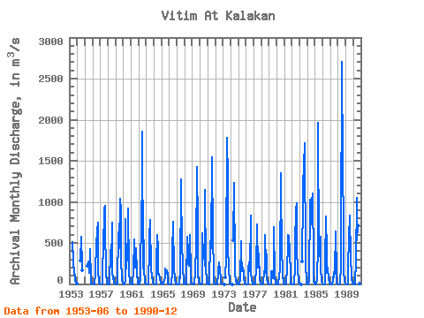
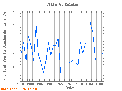
| Year | Jan | Feb | Mar | Apr | May | Jun | Jul | Aug | Sep | Oct | Nov | Dec | Annual | 1953 | 512.00 | 252.00 | 152.00 | 66.20 | 45.90 | 6.92 | 1.17 | 1954 | 289.00 | 580.00 | 208.00 | 169.00 | 1955 | 218.00 | 277.00 | 227.00 | 134.00 | 423.00 | 64.20 | 6.23 | 0.60 | 1956 | 0.29 | 0.00 | 0.00 | 0.00 | 131.00 | 157.00 | 480.00 | 637.00 | 742.00 | 182.00 | 12.50 | 0.50 | 195.19 | 1957 | 0.00 | 0.00 | 0.00 | 0.04 | 213.00 | 405.00 | 917.00 | 951.00 | 689.00 | 134.00 | 11.70 | 0.67 | 276.78 | 1958 | 0.00 | 0.00 | 0.00 | 6.91 | 419.00 | 214.00 | 743.00 | 148.00 | 63.00 | 77.30 | 19.30 | 6.91 | 141.45 | 1959 | 0.01 | 0.00 | 0.00 | 7.00 | 629.00 | 436.00 | 444.00 | 1040.00 | 898.00 | 308.00 | 48.40 | 1.02 | 317.62 | 1960 | 0.00 | 0.00 | 0.00 | 33.90 | 786.00 | 184.00 | 364.00 | 615.00 | 917.00 | 147.00 | 15.60 | 4.21 | 255.56 | 1961 | 0.43 | 0.00 | 0.00 | 1.01 | 171.00 | 539.00 | 271.00 | 199.00 | 439.00 | 132.00 | 17.60 | 2.95 | 147.75 | 1962 | 0.02 | 0.00 | 0.00 | 55.70 | 919.00 | 1090.00 | 1850.00 | 191.00 | 531.00 | 197.00 | 19.90 | 1.82 | 404.62 | 1963 | 0.00 | 0.00 | 0.00 | 0.08 | 449.00 | 569.00 | 776.00 | 164.00 | 166.00 | 114.00 | 15.10 | 0.88 | 187.84 | 1964 | 0.23 | 0.00 | 0.00 | 0.47 | 257.00 | 593.00 | 423.00 | 124.00 | 128.00 | 65.60 | 7.29 | 0.89 | 133.29 | 1965 | 0.06 | 0.00 | 0.00 | 0.06 | 49.50 | 76.60 | 190.00 | 119.00 | 172.00 | 106.00 | 7.19 | 0.24 | 60.05 | 1966 | 0.00 | 0.00 | 0.00 | 0.00 | 160.00 | 370.00 | 755.00 | 151.00 | 101.00 | 55.50 | 8.30 | 0.65 | 133.45 | 1967 | 0.00 | 0.00 | 0.00 | 2.74 | 95.90 | 67.60 | 1270.00 | 1110.00 | 522.00 | 205.00 | 13.40 | 1.70 | 274.03 | 1968 | 0.14 | 0.00 | 0.00 | 14.80 | 572.00 | 396.00 | 257.00 | 224.00 | 597.00 | 131.00 | 9.61 | 1.00 | 183.55 | 1969 | 0.44 | 0.09 | 0.00 | 0.46 | 141.00 | 200.00 | 416.00 | 1430.00 | 698.00 | 129.00 | 14.90 | 1.97 | 252.66 | 1970 | 0.19 | 0.00 | 0.00 | 28.40 | 616.00 | 308.00 | 482.00 | 217.00 | 1140.00 | 213.00 | 16.00 | 1.05 | 251.80 | 1971 | 0.03 | 0.00 | 0.00 | 12.60 | 524.00 | 440.00 | 434.00 | 1540.00 | 541.00 | 186.00 | 17.00 | 1.56 | 308.02 | 1972 | 0.00 | 0.00 | 0.00 | 4.80 | 114.00 | 156.00 | 262.00 | 154.00 | 67.60 | 20.90 | 1.92 | 0.23 | 65.12 | 1973 | 0.00 | 0.00 | 0.00 | 84.80 | 333.00 | 1780.00 | 1260.00 | 458.00 | 191.00 | 11.90 | 2.32 | 1974 | 0.00 | 0.00 | 0.00 | 535.00 | 1230.00 | 224.00 | 135.00 | 29.70 | 46.30 | 2.92 | 0.09 | 1975 | 0.00 | 0.00 | 0.00 | 63.20 | 519.00 | 381.00 | 152.00 | 199.00 | 136.00 | 73.80 | 5.40 | 0.11 | 127.46 | 1976 | 0.00 | 0.00 | 0.00 | 0.04 | 183.00 | 262.00 | 160.00 | 837.00 | 134.00 | 45.30 | 2.36 | 0.05 | 135.31 | 1977 | 0.00 | 0.00 | 0.00 | 0.00 | 200.00 | 730.00 | 202.00 | 203.00 | 372.00 | 52.90 | 4.26 | 0.22 | 147.03 | 1978 | 0.00 | 0.00 | 0.00 | 2.24 | 156.00 | 139.00 | 597.00 | 236.00 | 360.00 | 73.10 | 4.51 | 0.14 | 130.67 | 1979 | 0.00 | 0.00 | 0.00 | 0.13 | 151.00 | 141.00 | 66.80 | 253.00 | 690.00 | 87.10 | 2.58 | 0.16 | 115.98 | 1980 | 0.00 | 0.00 | 0.00 | 0.67 | 100.00 | 178.00 | 1350.00 | 1090.00 | 463.00 | 101.00 | 12.00 | 1.02 | 274.64 | 1981 | 0.00 | 0.00 | 0.00 | 6.52 | 201.00 | 456.00 | 600.00 | 590.00 | 391.00 | 126.00 | 9.37 | 0.65 | 198.38 | 1982 | 0.00 | 0.00 | 0.00 | 5.03 | 205.00 | 491.00 | 912.00 | 984.00 | 418.00 | 190.00 | 15.70 | 0.66 | 268.45 | 1983 | 0.00 | 0.00 | 0.00 | 275.00 | 1070.00 | 1580.00 | 1350.00 | 1720.00 | 255.00 | 21.50 | 2.96 | 1984 | 0.08 | 0.00 | 0.00 | 35.40 | 1030.00 | 729.00 | 882.00 | 1000.00 | 1100.00 | 242.00 | 22.50 | 3.69 | 420.39 | 1985 | 0.01 | 0.00 | 0.00 | 66.70 | 466.00 | 1960.00 | 335.00 | 469.00 | 580.00 | 207.00 | 29.20 | 4.20 | 343.09 | 1986 | 0.05 | 0.00 | 0.00 | 0.16 | 272.00 | 819.00 | 386.00 | 132.00 | 194.00 | 57.30 | 11.30 | 0.15 | 156.00 | 1987 | 0.00 | 0.00 | 0.00 | 0.00 | 37.70 | 150.00 | 80.90 | 151.00 | 641.00 | 128.00 | 11.70 | 0.75 | 100.09 | 1988 | 0.00 | 0.00 | 0.00 | 7.55 | 219.00 | 489.00 | 2700.00 | 1430.00 | 694.00 | 165.00 | 23.60 | 3.05 | 477.60 | 1989 | 0.09 | 0.00 | 0.00 | 0.61 | 206.00 | 559.00 | 835.00 | 322.00 | 346.00 | 78.40 | 8.30 | 0.63 | 196.34 | 1990 | 0.00 | 0.00 | 0.00 | 14.20 | 284.00 | 1050.00 | 530.00 | 714.00 | 683.00 | 275.00 | 8.62 | 0.96 | 296.65 |
|---|
| Other Close Sites | ||||||
|---|---|---|---|---|---|---|
| PointID | Latitude | Longitude | Drainage Area | Source | Name | |
| 6185 | "Kalakan At Kalakan" | 55.15 | 1718684 | SHI | 5.00 | |
 Return to R-Arctic Net Home Page