|
|
|||||||||||||||||
| Point ID: 6172 | Downloads | Plots | Site Data | Other Close Sites | Code: 3100 |
|
|
|||||||||||||||||
| Download | |
|---|---|
| Site Descriptor Information | Site Time Series Data |
| Link to all available data | |
| View: | Time Series | All |
| Units: | mm |
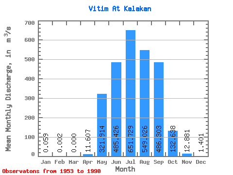
| Statistic | Jan | Feb | Mar | Apr | May | Jun | Jul | Aug | Sep | Oct | Nov | Dec | Annual |
|---|---|---|---|---|---|---|---|---|---|---|---|---|---|
| Mean | 0.06 | 0.00 | 0.00 | 11.61 | 321.91 | 485.43 | 651.73 | 549.03 | 486.30 | 132.64 | 12.88 | 1.40 | 218.03 |
| Standard Deviation | 0.12 | 0.01 | 0.00 | 19.08 | 247.11 | 385.31 | 569.06 | 467.87 | 357.45 | 73.04 | 8.89 | 1.49 | 103.47 |
| Min | 0.00 | 0.00 | 0.00 | 0.00 | 37.70 | 67.60 | 66.80 | 119.00 | 29.70 | 20.90 | 1.92 | 0.05 | 60.05 |
| Max | 0.44 | 0.09 | 0.00 | 66.70 | 1030.00 | 1960.00 | 2700.00 | 1540.00 | 1720.00 | 308.00 | 48.40 | 6.91 | 477.60 |
| Coefficient of Variation | 1.99 | 5.92 | 1.64 | 0.77 | 0.79 | 0.87 | 0.85 | 0.73 | 0.55 | 0.69 | 1.07 | 0.47 |
| Other Close Sites | ||||||
|---|---|---|---|---|---|---|
| PointID | Latitude | Longitude | Drainage Area | Source | Name | |
| 6185 | "Kalakan At Kalakan" | 55.15 | 1718684 | SHI | 5.00 | |
 Return to R-Arctic Net Home Page