|
|
|||||||||||||||||
| Point ID: 614 | Downloads | Plots | Site Data | Code: 07AF003 |
|
|
|||||||||||||||||
| Download | |
|---|---|
| Site Descriptor Information | Site Time Series Data |
| Link to all available data | |
| View: | Time Series | All |
| Units: | m3/s |
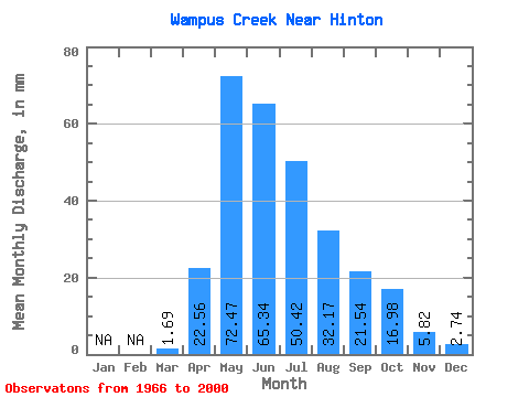
| Statistic | Jan | Feb | Mar | Apr | May | Jun | Jul | Aug | Sep | Oct | Nov | Dec | Annual |
|---|---|---|---|---|---|---|---|---|---|---|---|---|---|
| Mean | 1.69 | 22.53 | 72.47 | 65.31 | 50.40 | 32.16 | 21.51 | 16.99 | 5.77 | 2.74 | |||
| Standard Deviation | 18.64 | 38.57 | 50.60 | 39.56 | 27.35 | 16.63 | 12.75 | 3.10 | |||||
| Min | 1.69 | 3.67 | 18.35 | 12.15 | 8.44 | 4.85 | 3.78 | 3.16 | 3.57 | 2.74 | |||
| Max | 1.69 | 97.60 | 193.02 | 299.12 | 175.09 | 101.78 | 66.46 | 51.79 | 7.96 | 2.74 | |||
| Coefficient of Variation | 0.83 | 0.53 | 0.78 | 0.79 | 0.85 | 0.77 | 0.75 | 0.54 |
 Return to R-Arctic Net Home Page