|
|
|||||||||||||||||
| Point ID: 614 | Downloads | Plots | Site Data | Code: 07AF003 |
|
|
|||||||||||||||||
| Download | |
|---|---|
| Site Descriptor Information | Site Time Series Data |
| Link to all available data | |
| View: | Time Series | All |
| Units: | mm |
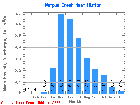
| Statistic | Jan | Feb | Mar | Apr | May | Jun | Jul | Aug | Sep | Oct | Nov | Dec | Annual |
|---|---|---|---|---|---|---|---|---|---|---|---|---|---|
| Mean | 0.02 | 0.22 | 0.69 | 0.64 | 0.48 | 0.30 | 0.21 | 0.16 | 0.06 | 0.03 | |||
| Standard Deviation | 0.18 | 0.37 | 0.50 | 0.38 | 0.26 | 0.16 | 0.12 | 0.03 | |||||
| Min | 0.02 | 0.04 | 0.17 | 0.12 | 0.08 | 0.05 | 0.04 | 0.03 | 0.04 | 0.03 | |||
| Max | 0.02 | 0.96 | 1.83 | 2.93 | 1.66 | 0.96 | 0.65 | 0.49 | 0.08 | 0.03 | |||
| Coefficient of Variation | 0.83 | 0.53 | 0.78 | 0.79 | 0.85 | 0.77 | 0.75 | 0.54 |
 Return to R-Arctic Net Home Page