|
|
|||||||||||||||||
| Point ID: 597 | Downloads | Plots | Site Data | Code: 07AC007 |
|
|
|||||||||||||||||
| Download | |
|---|---|
| Site Descriptor Information | Site Time Series Data |
| Link to all available data | |
|
|
| View: | Statistics | Time Series |
| Units: | mm |
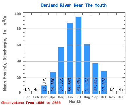
| Statistic | Jan | Feb | Mar | Apr | May | Jun | Jul | Aug | Sep | Oct | Nov | Dec | Annual |
|---|---|---|---|---|---|---|---|---|---|---|---|---|---|
| Mean | 10.38 | 26.68 | 57.05 | 86.87 | 94.87 | 61.15 | 37.33 | 27.87 | |||||
| Standard Deviation | 3.28 | 10.16 | 25.96 | 41.88 | 52.83 | 43.11 | 17.83 | 12.04 | |||||
| Min | 6.30 | 17.30 | 19.60 | 31.30 | 27.20 | 18.20 | 15.40 | 14.20 | |||||
| Max | 21.00 | 44.20 | 132.00 | 186.00 | 212.00 | 175.00 | 82.80 | 61.20 | |||||
| Coefficient of Variation | 0.32 | 0.38 | 0.46 | 0.48 | 0.56 | 0.70 | 0.48 | 0.43 |
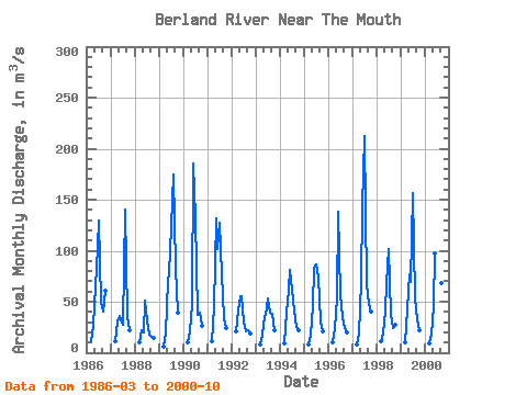
| Year | Jan | Feb | Mar | Apr | May | Jun | Jul | Aug | Sep | Oct | Nov | Dec | Annual | 1986 | 11.20 | 26.00 | 66.30 | 80.80 | 130.00 | 50.40 | 40.10 | 61.20 | 1987 | 11.30 | 30.30 | 35.50 | 31.30 | 27.20 | 140.00 | 36.10 | 22.50 | 1988 | 10.60 | 21.70 | 19.60 | 51.60 | 32.20 | 18.20 | 15.40 | 14.20 | 1989 | 6.30 | 18.60 | 70.80 | 78.30 | 123.00 | 175.00 | 82.80 | 39.60 | 1990 | 10.50 | 21.50 | 47.60 | 186.00 | 133.00 | 37.30 | 39.50 | 26.50 | 1991 | 11.00 | 44.20 | 132.00 | 102.00 | 127.00 | 77.00 | 33.80 | 23.80 | 1992 | 21.00 | 41.70 | 54.90 | 55.20 | 30.00 | 21.40 | 21.60 | 18.30 | 1993 | 7.96 | 17.70 | 36.00 | 36.90 | 53.70 | 38.80 | 38.10 | 22.20 | 1994 | 9.13 | 39.40 | 61.90 | 81.50 | 61.30 | 41.60 | 25.50 | 22.00 | 1995 | 8.18 | 17.30 | 46.10 | 83.40 | 86.80 | 73.70 | 30.50 | 21.00 | 1996 | 10.20 | 24.70 | 53.40 | 138.00 | 56.80 | 34.70 | 24.10 | 19.50 | 1997 | 8.36 | 18.50 | 69.30 | 143.00 | 212.00 | 67.00 | 47.70 | 40.10 | 1998 | 10.90 | 19.20 | 39.80 | 68.30 | 102.00 | 37.70 | 24.10 | 27.80 | 1999 | 10.20 | 42.10 | 77.10 | 69.60 | 156.00 | 52.90 | 32.30 | 22.10 | 2000 | 8.86 | 17.30 | 45.50 | 97.10 | 92.00 | 51.60 | 68.30 | 37.30 |
|---|
 Return to R-Arctic Net Home Page