|
|
|||||||||||||||||
| Point ID: 5918 | Downloads | Plots | Site Data | Code: 1499 |
|
|
|||||||||||||||||
| Download | |
|---|---|
| Site Descriptor Information | Site Time Series Data |
| Link to all available data | |
|
|
| View: | Statistics | Time Series |
| Units: | mm |
| Statistic | Jan | Feb | Mar | Apr | May | Jun | Jul | Aug | Sep | Oct | Nov | Dec | Annual |
|---|---|---|---|---|---|---|---|---|---|---|---|---|---|
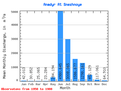
| Mean | 42.01 | 30.85 | 25.07 | 23.28 | 284.19 | 4980.65 | 3008.07 | 1586.68 | 1298.16 | 452.13 | 117.06 | 64.91 | 992.75 |
| Standard Deviation | 14.00 | 10.76 | 7.78 | 7.49 | 413.28 | 933.30 | 1397.48 | 467.02 | 599.00 | 249.98 | 46.29 | 20.52 | 170.46 |
| Min | 24.10 | 15.40 | 11.90 | 7.50 | 25.00 | 2950.00 | 1010.00 | 734.00 | 454.00 | 127.00 | 63.30 | 26.50 | 689.71 |
| Max | 74.80 | 57.50 | 42.00 | 40.50 | 2160.00 | 6730.00 | 6190.00 | 2420.00 | 2800.00 | 1170.00 | 278.00 | 116.00 | 1352.68 |
| Coefficient of Variation | 0.33 | 0.35 | 0.31 | 0.32 | 1.45 | 0.19 | 0.47 | 0.29 | 0.46 | 0.55 | 0.40 | 0.32 | 0.17 |
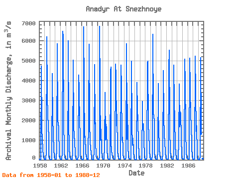
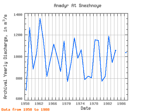
| Year | Jan | Feb | Mar | Apr | May | Jun | Jul | Aug | Sep | Oct | Nov | Dec | Annual | 1958 | 25.60 | 15.40 | 12.90 | 15.70 | 27.70 | 4720.00 | 1590.00 | 1010.00 | 595.00 | 141.00 | 77.10 | 46.10 | 689.71 | 1959 | 27.10 | 22.80 | 19.50 | 19.00 | 412.00 | 6210.00 | 3350.00 | 2140.00 | 1870.00 | 938.00 | 151.00 | 53.90 | 1267.78 | 1960 | 28.20 | 15.70 | 16.40 | 18.10 | 35.00 | 4350.00 | 1980.00 | 2180.00 | 1210.00 | 600.00 | 119.00 | 69.70 | 885.17 | 1961 | 42.10 | 30.00 | 25.90 | 25.90 | 532.00 | 5850.00 | 2000.00 | 1800.00 | 1680.00 | 190.00 | 97.30 | 57.90 | 1027.59 | 1962 | 31.90 | 27.90 | 26.10 | 24.50 | 389.00 | 6480.00 | 6190.00 | 1880.00 | 646.00 | 352.00 | 132.00 | 52.80 | 1352.68 | 1963 | 35.60 | 31.00 | 30.00 | 30.90 | 33.80 | 4870.00 | 6000.00 | 1830.00 | 665.00 | 127.00 | 81.30 | 61.60 | 1149.68 | 1964 | 34.90 | 21.60 | 19.00 | 16.60 | 393.00 | 5040.00 | 1740.00 | 1160.00 | 958.00 | 265.00 | 81.30 | 70.10 | 816.62 | 1965 | 54.00 | 17.30 | 11.90 | 11.80 | 164.00 | 4290.00 | 3520.00 | 1810.00 | 1360.00 | 265.00 | 71.40 | 58.00 | 969.45 | 1966 | 34.60 | 23.50 | 17.80 | 14.30 | 77.90 | 6700.00 | 3580.00 | 1140.00 | 1180.00 | 337.00 | 201.00 | 85.80 | 1115.99 | 1967 | 28.90 | 24.90 | 23.90 | 22.40 | 2160.00 | 5830.00 | 1860.00 | 951.00 | 547.00 | 418.00 | 98.40 | 48.60 | 1001.09 | 1968 | 38.00 | 25.00 | 18.80 | 16.70 | 477.00 | 4810.00 | 1830.00 | 1860.00 | 907.00 | 214.00 | 87.50 | 54.70 | 861.56 | 1969 | 35.10 | 30.60 | 17.90 | 20.00 | 179.00 | 6730.00 | 3480.00 | 995.00 | 1550.00 | 509.00 | 113.00 | 70.30 | 1144.16 | 1970 | 44.30 | 28.90 | 25.30 | 25.50 | 639.00 | 3390.00 | 1010.00 | 1800.00 | 1540.00 | 488.00 | 174.00 | 92.10 | 771.42 | 1971 | 57.20 | 43.60 | 26.40 | 20.30 | 41.80 | 4500.00 | 4670.00 | 883.00 | 454.00 | 301.00 | 128.00 | 72.00 | 933.11 | 1972 | 39.40 | 30.30 | 31.90 | 30.20 | 56.20 | 4840.00 | 4260.00 | 1730.00 | 2300.00 | 453.00 | 192.00 | 99.30 | 1171.86 | 1973 | 71.60 | 50.00 | 32.40 | 29.20 | 45.90 | 4770.00 | 3710.00 | 984.00 | 1130.00 | 622.00 | 278.00 | 116.00 | 986.59 | 1974 | 56.10 | 43.20 | 30.20 | 26.30 | 76.40 | 5860.00 | 1900.00 | 1030.00 | 2800.00 | 721.00 | 130.00 | 70.00 | 1061.93 | 1975 | 63.00 | 49.30 | 41.40 | 40.50 | 153.00 | 4970.00 | 1750.00 | 734.00 | 1080.00 | 450.00 | 75.30 | 41.60 | 787.34 | 1976 | 24.10 | 19.10 | 16.40 | 7.50 | 25.00 | 3890.00 | 2580.00 | 1990.00 | 866.00 | 258.00 | 94.30 | 47.10 | 818.12 | 1977 | 28.40 | 24.70 | 21.00 | 20.00 | 56.40 | 2950.00 | 1950.00 | 1550.00 | 1820.00 | 1080.00 | 117.00 | 58.90 | 806.37 | 1978 | 44.50 | 38.40 | 30.20 | 29.70 | 113.00 | 4880.00 | 4990.00 | 1630.00 | 1450.00 | 471.00 | 116.00 | 81.60 | 1156.20 | 1979 | 45.60 | 35.10 | 27.90 | 24.70 | 246.00 | 6330.00 | 2340.00 | 2200.00 | 1960.00 | 409.00 | 117.00 | 63.40 | 1149.89 | 1980 | 45.20 | 32.90 | 28.40 | 28.00 | 468.00 | 3860.00 | 2230.00 | 1700.00 | 519.00 | 257.00 | 87.20 | 32.80 | 774.04 | 1981 | 24.60 | 23.60 | 20.70 | 19.70 | 313.00 | 4500.00 | 2200.00 | 1230.00 | 924.00 | 395.00 | 85.40 | 79.40 | 817.95 | 1982 | 50.70 | 36.60 | 31.50 | 25.80 | 34.50 | 4590.00 | 5520.00 | 1780.00 | 1470.00 | 528.00 | 119.00 | 92.90 | 1189.92 | 1983 | 58.50 | 44.80 | 37.90 | 36.30 | 304.00 | 4780.00 | 2820.00 | 2130.00 | 663.00 | 365.00 | 63.30 | 40.50 | 945.27 | 1984 | 33.70 | 24.20 | 21.90 | 19.60 | 964.00 | 3820.00 | 1670.00 | 2420.00 | 2330.00 | 1170.00 | 134.00 | 77.00 | 1057.03 | 1985 | 74.80 | 57.50 | 42.00 | 34.00 | 40.10 | 5080.00 | 3860.00 | 1750.00 | 1430.00 | 381.00 | 93.80 | 81.00 | 1077.02 | 1986 | 57.30 | 41.50 | 32.40 | 32.80 | 120.00 | 5130.00 | 3680.00 | 2140.00 | 1840.00 | 629.00 | 160.00 | 71.80 | 1161.23 | 1987 | 41.10 | 23.60 | 21.50 | 19.80 | 76.30 | 5220.00 | 3440.00 | 1440.00 | 1730.00 | 323.00 | 81.30 | 38.80 | 1037.95 | 1988 | 26.30 | 23.40 | 17.50 | 16.00 | 157.00 | 5160.00 | 1550.00 | 1310.00 | 769.00 | 359.00 | 73.00 | 26.50 | 790.64 |
|---|
 Return to R-Arctic Net Home Page