|
|
|||||||||||||||||
| Point ID: 5877 | Downloads | Plots | Site Data | Code: 1163 |
|
|
|||||||||||||||||
| Download | |
|---|---|
| Site Descriptor Information | Site Time Series Data |
| Link to all available data | |
| View: | Time Series | All |
| Units: | m3/s |
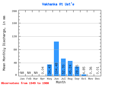
| Statistic | Jan | Feb | Mar | Apr | May | Jun | Jul | Aug | Sep | Oct | Nov | Dec | Annual |
|---|---|---|---|---|---|---|---|---|---|---|---|---|---|
| Mean | 0.04 | 34.42 | 104.48 | 52.69 | 45.23 | 28.64 | 4.85 | 0.36 | 0.01 | ||||
| Standard Deviation | 20.73 | 41.49 | 29.59 | 24.82 | 18.11 | 3.15 | 0.31 | ||||||
| Min | 0.04 | 9.26 | 52.40 | 22.58 | 17.23 | 7.29 | 0.41 | 0.04 | 0.01 | ||||
| Max | 0.04 | 75.71 | 198.95 | 147.65 | 95.68 | 71.03 | 11.87 | 0.90 | 0.01 | ||||
| Coefficient of Variation | 0.60 | 0.40 | 0.56 | 0.55 | 0.63 | 0.65 | 0.86 |
 Return to R-Arctic Net Home Page