|
|
|||||||||||||||||
| Point ID: 5877 | Downloads | Plots | Site Data | Code: 1163 |
|
|
|||||||||||||||||
| Download | |
|---|---|
| Site Descriptor Information | Site Time Series Data |
| Link to all available data | |
| View: | Time Series | All |
| Units: | mm |
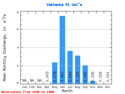
| Statistic | Jan | Feb | Mar | Apr | May | Jun | Jul | Aug | Sep | Oct | Nov | Dec | Annual |
|---|---|---|---|---|---|---|---|---|---|---|---|---|---|
| Mean | 0.00 | 2.38 | 7.46 | 3.64 | 3.12 | 2.04 | 0.34 | 0.03 | 0.00 | ||||
| Standard Deviation | 1.43 | 2.96 | 2.04 | 1.71 | 1.29 | 0.22 | 0.02 | ||||||
| Min | 0.00 | 0.64 | 3.74 | 1.56 | 1.19 | 0.52 | 0.03 | 0.00 | 0.00 | ||||
| Max | 0.00 | 5.23 | 14.20 | 10.20 | 6.61 | 5.07 | 0.82 | 0.06 | 0.00 | ||||
| Coefficient of Variation | 0.60 | 0.40 | 0.56 | 0.55 | 0.63 | 0.65 | 0.86 |
 Return to R-Arctic Net Home Page